Saint-Léonard, Pas-de-Calais
Saint-Léonard is a commune in the Pas-de-Calais department in the Hauts-de-France region of France.
Saint-Léonard | |
|---|---|
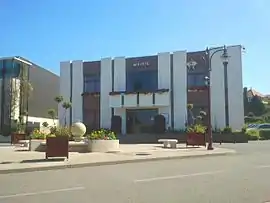 The town hall of Saint-Léonard | |
 Coat of arms | |
Location of Saint-Léonard 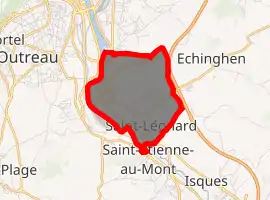
| |
 Saint-Léonard  Saint-Léonard | |
| Coordinates: 50°41′28″N 1°37′31″E | |
| Country | France |
| Region | Hauts-de-France |
| Department | Pas-de-Calais |
| Arrondissement | Boulogne-sur-Mer |
| Canton | Outreau |
| Intercommunality | Communauté d'agglomération du Boulonnais |
| Government | |
| • Mayor (2008–2014) | Jean-Loup Lesaffre |
| Area 1 | 3.4 km2 (1.3 sq mi) |
| Population (2017-01-01)[1] | 3,452 |
| • Density | 1,000/km2 (2,600/sq mi) |
| Time zone | UTC+01:00 (CET) |
| • Summer (DST) | UTC+02:00 (CEST) |
| INSEE/Postal code | 62755 /62360 |
| Elevation | 2–110 m (6.6–360.9 ft) (avg. 7 m or 23 ft) |
| 1 French Land Register data, which excludes lakes, ponds, glaciers > 1 km2 (0.386 sq mi or 247 acres) and river estuaries. | |
Geography
Saint-Léonard is a farming and light industrial town, situated some 2 miles (3.2 km) south of Boulogne, at the junction of the D901 and D940 roads. The A16 autoroute forms the eastern border of the commune and the river Liane the western.
Population
| Year | Pop. | ±% p.a. |
|---|---|---|
| 1968 | 1,547 | — |
| 1975 | 3,929 | +14.24% |
| 1982 | 4,021 | +0.33% |
| 1990 | 4,131 | +0.34% |
| 1999 | 3,952 | −0.49% |
| 2007 | 3,628 | −1.06% |
| 2012 | 3,616 | −0.07% |
| 2017 | 3,452 | −0.92% |
| Source: INSEE[2] | ||
Places of interest
- The church of St.Léonard, dating from the twelfth century and now a historical monument.[3]
- The modern church of St. Therése
- The Château de Pont-de-Briques, (dating from the seventeenth century), a registered monument.[4]
- The nineteenth century Château Neuf.[5]
- Château des Lions (also known as Château Muhlberg), a château from the nineteenth century, now an orphanage[6]
References
External links
| Wikimedia Commons has media related to Saint-Léonard (Pas-de-Calais). |
- Official website of the commune of Saint-Léonard (in French)
| Authority control |
|---|
This article is issued from Wikipedia. The text is licensed under Creative Commons - Attribution - Sharealike. Additional terms may apply for the media files.