Saint-Hilaire-Cottes
Saint-Hilaire-Cottes is a commune in the Pas-de-Calais department in the Hauts-de-France region of France.
Saint-Hilaire-Cottes | |
|---|---|
_mairie.JPG.webp) The town hall of Saint-Hilaire-Cottes | |
 Coat of arms | |
Location of Saint-Hilaire-Cottes 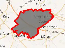
| |
 Saint-Hilaire-Cottes  Saint-Hilaire-Cottes | |
| Coordinates: 50°34′20″N 2°24′54″E | |
| Country | France |
| Region | Hauts-de-France |
| Department | Pas-de-Calais |
| Arrondissement | Béthune |
| Canton | Aire-sur-la-Lys |
| Intercommunality | CA Béthune-Bruay, Artois-Lys Romane |
| Government | |
| • Mayor (2008–2014) | Philippe Cauwet |
| Area 1 | 7.24 km2 (2.80 sq mi) |
| Population (2017-01-01)[1] | 807 |
| • Density | 110/km2 (290/sq mi) |
| Time zone | UTC+01:00 (CET) |
| • Summer (DST) | UTC+02:00 (CEST) |
| INSEE/Postal code | 62750 /62120 |
| Elevation | 24–102 m (79–335 ft) (avg. 65 m or 213 ft) |
| 1 French Land Register data, which excludes lakes, ponds, glaciers > 1 km2 (0.386 sq mi or 247 acres) and river estuaries. | |
Geography
Saint-Hilaire-Cottes is situated some 10 miles (16.1 km) northwest of Béthune and 37 miles (59.5 km) west of Lille, at the junction of the D943 and D91 roads.
Population
| Year | Pop. | ±% p.a. |
|---|---|---|
| 1968 | 753 | — |
| 1975 | 725 | −0.54% |
| 1982 | 752 | +0.52% |
| 1990 | 750 | −0.03% |
| 1999 | 734 | −0.24% |
| 2007 | 807 | +1.19% |
| 2012 | 822 | +0.37% |
| 2017 | 807 | −0.37% |
| Source: INSEE[2] | ||
Places of interest
- The church of St. Hilaire, dating from the sixteenth century.
- The church of St. Omer, at Cottes, dating from the fifteenth century.
- The Commonwealth War Graves Commission graves.
References
- "Populations légales 2017". INSEE. Retrieved 6 January 2020.
- Population en historique depuis 1968, INSEE
This article is issued from Wikipedia. The text is licensed under Creative Commons - Attribution - Sharealike. Additional terms may apply for the media files.