Labourse
Labourse is a commune in the Pas-de-Calais department in the Hauts-de-France region of France.
Labourse | |
|---|---|
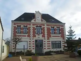 The town hall of Labourse | |
 Coat of arms | |
Location of Labourse 
| |
 Labourse  Labourse | |
| Coordinates: 50°29′56″N 2°40′51″E | |
| Country | France |
| Region | Hauts-de-France |
| Department | Pas-de-Calais |
| Arrondissement | Béthune |
| Canton | Nœux-les-Mines |
| Intercommunality | CA Béthune-Bruay, Artois-Lys Romane |
| Government | |
| • Mayor (2008–2014) | François Dobrowolski |
| Area 1 | 4.7 km2 (1.8 sq mi) |
| Population | 2,847 |
| • Density | 610/km2 (1,600/sq mi) |
| Time zone | UTC+01:00 (CET) |
| • Summer (DST) | UTC+02:00 (CEST) |
| INSEE/Postal code | 62480 /62113 |
| Elevation | 18–44 m (59–144 ft) (avg. 25 m or 82 ft) |
| 1 French Land Register data, which excludes lakes, ponds, glaciers > 1 km2 (0.386 sq mi or 247 acres) and river estuaries. | |
Geography
A large farming and light industrial village, situated some 3 miles (4.8 km) southeast of Béthune and 22 miles (35.4 km) southwest of Lille on the D65 and the D943. The commune is also traversed by the A26 autoroute.
Population
| Year | 1962 | 1968 | 1975 | 1982 | 1990 | 1999 | 2006 |
|---|---|---|---|---|---|---|---|
| Population | 2130 | 2201 | 1926 | 1711 | 2057 | 2028 | 2190 |
| From the year 1962 on: No double counting—residents of multiple communes (e.g. students and military personnel) are counted only once. | |||||||
Places of interest
- A nineteenth-century chateau.
- The church of St. Martin, rebuilt in the 16th century.
- The chapel, rebuilt, along with most of the village, after World War I.
- A museum, telling of the deportations of World War II.
This article is issued from Wikipedia. The text is licensed under Creative Commons - Attribution - Sharealike. Additional terms may apply for the media files.
