Sars-le-Bois
Sars-le-Bois is a commune in the Pas-de-Calais department in the Hauts-de-France region of France.
Sars-le-Bois | |
|---|---|
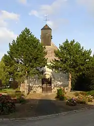 The church of Sars-le-Bois | |
 Coat of arms | |
Location of Sars-le-Bois 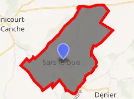
| |
 Sars-le-Bois  Sars-le-Bois | |
| Coordinates: 50°17′45″N 2°25′46″E | |
| Country | France |
| Region | Hauts-de-France |
| Department | Pas-de-Calais |
| Arrondissement | Arras |
| Canton | Avesnes-le-Comte |
| Intercommunality | CC Campagnes de l'Artois |
| Government | |
| • Mayor (2008–2014) | Albert Locquet |
| Area 1 | 2.39 km2 (0.92 sq mi) |
| Population | 82 |
| • Density | 34/km2 (89/sq mi) |
| Time zone | UTC+01:00 (CET) |
| • Summer (DST) | UTC+02:00 (CEST) |
| INSEE/Postal code | 62778 /62810 |
| Elevation | 95–141 m (312–463 ft) (avg. 136 m or 446 ft) |
| 1 French Land Register data, which excludes lakes, ponds, glaciers > 1 km2 (0.386 sq mi or 247 acres) and river estuaries. | |
Geography
Sars-le-Bois lies on the banks of the river Canche, some 16 miles (25.7 km) west of Arras, on the D79E road.
Population
| Year | Pop. | ±% p.a. |
|---|---|---|
| 1968 | 86 | — |
| 1975 | 69 | −3.10% |
| 1982 | 66 | −0.63% |
| 1990 | 62 | −0.78% |
| 1999 | 66 | +0.70% |
| 2007 | 68 | +0.37% |
| 2012 | 69 | +0.29% |
| 2017 | 82 | +3.51% |
| Source: INSEE[2] | ||
Places of interest
- The church of St.Nicholas, dating from the eighteenth century.
References
- "Populations légales 2017". INSEE. Retrieved 6 January 2020.
- Population en historique depuis 1968, INSEE
| Wikimedia Commons has media related to Sars-le-Bois. |
| Authority control |
|---|
This article is issued from Wikipedia. The text is licensed under Creative Commons - Attribution - Sharealike. Additional terms may apply for the media files.