Lozinghem
Lozinghem is a commune in the Pas-de-Calais department in the Hauts-de-France region of France.
Lozinghem | |
|---|---|
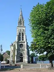 The church of Lozinghem | |
 Coat of arms | |
Location of Lozinghem 
| |
 Lozinghem  Lozinghem | |
| Coordinates: 50°31′06″N 2°30′03″E | |
| Country | France |
| Region | Hauts-de-France |
| Department | Pas-de-Calais |
| Arrondissement | Béthune |
| Canton | Auchel |
| Intercommunality | CA Béthune-Bruay, Artois-Lys Romane |
| Government | |
| • Mayor (2008–2014) | Jacques Laden |
| Area 1 | 2.15 km2 (0.83 sq mi) |
| Population (2017-01-01)[1] | 1,262 |
| • Density | 590/km2 (1,500/sq mi) |
| Time zone | UTC+01:00 (CET) |
| • Summer (DST) | UTC+02:00 (CEST) |
| INSEE/Postal code | 62532 /62540 |
| Elevation | 38–99 m (125–325 ft) (avg. 67 m or 220 ft) |
| 1 French Land Register data, which excludes lakes, ponds, glaciers > 1 km2 (0.386 sq mi or 247 acres) and river estuaries. | |
Geography
Lozinghem is situated some 7 miles (11.3 km) west of Béthune and 33 miles (53.1 km) southwest of Lille, at the junction of the D188 and D183 roads.
Population
| Year | Pop. | ±% p.a. |
|---|---|---|
| 1968 | 1,231 | — |
| 1975 | 1,169 | −0.74% |
| 1982 | 1,104 | −0.81% |
| 1990 | 1,055 | −0.57% |
| 1999 | 1,032 | −0.24% |
| 2007 | 1,161 | +1.48% |
| 2012 | 1,264 | +1.71% |
| 2017 | 1,262 | −0.03% |
| Source: INSEE[2] | ||
Places of interest
- A sixteenth century manorhouse.
- A farmhouse dating from the seventeenth century.
- The church of St. Riquier, built in 1866.
- A chapel
References
- "Populations légales 2017". INSEE. Retrieved 6 January 2020.
- Population en historique depuis 1968, INSEE
| Wikimedia Commons has media related to Lozinghem. |
| Authority control |
|---|
This article is issued from Wikipedia. The text is licensed under Creative Commons - Attribution - Sharealike. Additional terms may apply for the media files.
