Labeuvrière
Labeuvrière is a commune in the Pas-de-Calais department in the Hauts-de-France region of France.
Labeuvrière | |
|---|---|
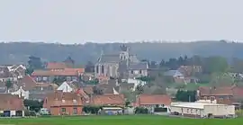 A general view of Labeuvrière | |
 Coat of arms | |
Location of Labeuvrière 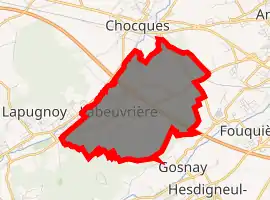
| |
 Labeuvrière  Labeuvrière | |
| Coordinates: 50°31′15″N 2°33′50″E | |
| Country | France |
| Region | Hauts-de-France |
| Department | Pas-de-Calais |
| Arrondissement | Béthune |
| Canton | Béthune |
| Intercommunality | CA Béthune-Bruay, Artois-Lys Romane |
| Government | |
| • Mayor (2008–2014) | Michel Leroy |
| Area 1 | 6.11 km2 (2.36 sq mi) |
| Population (2017-01-01)[1] | 1,645 |
| • Density | 270/km2 (700/sq mi) |
| Time zone | UTC+01:00 (CET) |
| • Summer (DST) | UTC+02:00 (CEST) |
| INSEE/Postal code | 62479 /62122 |
| Elevation | 23–75 m (75–246 ft) (avg. 36 m or 118 ft) |
| 1 French Land Register data, which excludes lakes, ponds, glaciers > 1 km2 (0.386 sq mi or 247 acres) and river estuaries. | |
Geography
A large farming and light industrial village, situated some 4 miles (6.4 km) west of Béthune and 20 miles (32.2 km) southwest of Lille on the D181e5, traversed by the A26 autoroute.
Population
| Year | 1962 | 1968 | 1975 | 1982 | 1990 | 1999 | 2006 |
|---|---|---|---|---|---|---|---|
| Population | 1857 | 1953 | 1702 | 1714 | 1702 | 1710 | 1671 |
| From the year 1962 on: No double counting—residents of multiple communes (e.g. students and military personnel) are counted only once. | |||||||
Places of interest
- The church of St. Christine, rebuilt, along with the rest of the village, after World War I.
- The ancient priory (fr: prévoté) of the abbey of St.Vaast, now the mairie.
This article is issued from Wikipedia. The text is licensed under Creative Commons - Attribution - Sharealike. Additional terms may apply for the media files.