Jackson County, Georgia
Jackson County is a county located in the northeastern part of the U.S. state of Georgia. As of the 2010 census, the population was 60,485.[1] The county seat is Jefferson.[2]
Jackson County | |
|---|---|
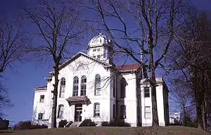 Jackson County courthouse in Jefferson | |
 Seal | |
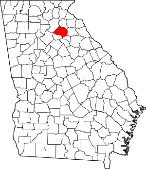 Location within the U.S. state of Georgia | |
 Georgia's location within the U.S. | |
| Coordinates: 34°08′N 83°34′W | |
| Country | |
| State | |
| Founded | 1796 |
| Named for | James Jackson |
| Seat | Jefferson |
| Largest city | Jefferson |
| Area | |
| • Total | 343 sq mi (890 km2) |
| • Land | 340 sq mi (900 km2) |
| • Water | 3.4 sq mi (9 km2) 1.0%% |
| Population | |
| • Estimate (2018) | 70,422 |
| • Density | 205/sq mi (79/km2) |
| Time zone | UTC−5 (Eastern) |
| • Summer (DST) | UTC−4 (EDT) |
| Congressional district | 9th |
| Website | www |
Jackson County comprises the Jefferson, GA Micropolitan Statistical Area, which is included in the Atlanta-Athens-Clarke County-Sandy Springs, GA Combined Statistical Area.
History
Most of the first non-Native American settlers came from Effingham County in 1786.[3] On February 11, 1796, Jackson County was split off from part of Franklin County, Georgia. The new county was named in honor of Revolutionary War Lieutenant Colonel, Congressman, Senator and Governor James Jackson.[4] The county originally covered an area of approximately 1,800 square miles (4,662.0 km2), with Clarksboro as its first county seat.
In 1801, the Georgia General Assembly granted 40,000 acres (160 km2) of land in Jackson County for a state college. Franklin College (now University of Georgia) began classes the same year, and the city of Athens was developed around the school. Also the same year, a new county was developed around the new college town, and Jackson lost territory to the new Clarke. The county seat was moved to an old Indian village called Thomocoggan, a location with ample water supply from Curry Creek and four large springs. In 1804, the city was renamed Jefferson, after Thomas Jefferson.
Jackson lost more territory in 1811 in the creation of Madison County, in 1818 in the creation of Walton, Gwinnett, and Hall counties, in 1858 in the creation of Banks County,[5] and in 1914 in the creation of Barrow County.
The first county courthouse, a log and wooden frame building with an attached jail, was built on south side of the public square; a second, larger, two-story brick courthouse with a separate jailhouse was built in 1817. In 1880, a third was built on a hill north of the square. This courthouse was the oldest continuously operating courthouse in the United States until 2004, when the current courthouse was constructed north of Jefferson.
Law and government
| Commission post | Office holder |
| Chairman | Tom Crow (Jackson County, Georgia) |
| District 1 - Central Jackson | Jim Hix |
| District 2 - North Jackson | Chas Hardy |
| District 3 - West Jackson | Ralph Richardson, Jr. |
| District 4 - East Jackson | Marty Seagraves |
| Year | Republican | Democratic | Third parties |
|---|---|---|---|
| 2020 | 78.3% 29,497 | 20.3% 7,642 | 1.4% 531 |
| 2016 | 79.4% 21,784 | 16.4% 4,491 | 4.2% 1,146 |
| 2012 | 80.6% 19,135 | 17.9% 4,238 | 1.6% 372 |
| 2008 | 77.2% 17,776 | 21.5% 4,950 | 1.3% 290 |
| 2004 | 77.8% 12,611 | 21.4% 3,468 | 0.8% 123 |
| 2000 | 67.7% 7,878 | 29.4% 3,420 | 2.9% 337 |
| 1996 | 50.4% 4,782 | 39.5% 3,746 | 10.2% 964 |
| 1992 | 43.4% 3,976 | 41.4% 3,792 | 15.2% 1,397 |
| 1988 | 62.6% 4,407 | 37.0% 2,607 | 0.4% 31 |
| 1984 | 60.7% 4,202 | 39.3% 2,717 | |
| 1980 | 31.8% 2,209 | 66.1% 4,591 | 2.1% 149 |
| 1976 | 17.3% 1,239 | 82.7% 5,931 | |
| 1972 | 79.6% 4,124 | 20.4% 1,055 | |
| 1968 | 18.5% 1,139 | 25.0% 1,537 | 56.5% 3,473 |
| 1964 | 29.6% 1,664 | 70.4% 3,953 | |
| 1960 | 11.4% 472 | 88.6% 3,653 | |
| 1956 | 12.4% 438 | 87.6% 3,100 | |
| 1952 | 10.9% 409 | 89.1% 3,341 | |
| 1948 | 6.5% 145 | 84.0% 1,866 | 9.5% 211 |
| 1944 | 11.2% 221 | 88.8% 1,754 | |
| 1940 | 9.4% 166 | 90.3% 1,599 | 0.3% 6 |
| 1936 | 7.1% 187 | 92.8% 2,447 | 0.2% 4 |
| 1932 | 5.4% 80 | 93.5% 1,389 | 1.1% 16 |
| 1928 | 48.8% 818 | 51.2% 859 | |
| 1924 | 11.7% 142 | 81.8% 993 | 6.5% 79 |
| 1920 | 23.8% 334 | 76.2% 1,069 | |
| 1916 | 7.5% 102 | 87.3% 1,185 | 5.2% 71 |
| 1912 | 32.7% 568 | 64.7% 1,123 | 2.7% 46 |
Geography
According to the U.S. Census Bureau, the county has a total area of 343 square miles (890 km2), of which 340 square miles (880 km2) is land and 3.4 square miles (8.8 km2) (1.0%) is water.[8]
The vast majority of Jackson County is located in the Upper Oconee River sub-basin of the Altamaha River basin, with just a small portion of the county's northern edge, between Maysville to just east of Commerce, located in the Broad River sub-basin of the Savannah River basin.[9]
Rivers and creeks
- North Oconee River
- Sandy Creek (Georgia)
- Curry Creek
- Middle Oconee River
- Pond Fork
- Allen Creek (Holders Creek)
- Mulberry River
Adjacent counties
- Banks County - north
- Madison County - east
- Clarke County - southeast
- Gwinnett County - southwest
- Barrow County - west
- Hall County - northwest
Transportation
Major highways
 Interstate 85
 U.S. Route 129
 U.S. Route 129 Business
 U.S. Route 441
- U.S. Route 441 Business
 State Route 11
 State Route 11 Business
 State Route 11 Connector
 State Route 15
 State Route 15 Alternate
 State Route 53
 State Route 59
 State Route 60
 State Route 82
 State Route 82 Connector
 State Route 98
 State Route 124
 State Route 330
 State Route 332
 State Route 334
 State Route 335
 State Route 346 (former)
 State Route 403 (unsigned designation for I-85)
Pedestrians and cycling
- Fox Smallwood Dr Trail[10]
- American Veterans Memorial Park Trail
- Commerce Middle School Track
- Curry Creek Reservoir Trail
- Jefferson Memorial Stadium Track
- East Jackson Park Walking Trail
- South Jackson Elementary Nature Trail & Walking Track
- Hurricane Shoals Nature Trail
- Sells Mill Nature Trail
- Sandy Creek Park Walking Trail
- Braselton Riverwalk Trail
- East Jackson High School Track
- W Jackson Middle School Track
- West Jackson Park Walking Track
Demographics
| Historical population | |||
|---|---|---|---|
| Census | Pop. | %± | |
| 1800 | 7,736 | — | |
| 1810 | 10,569 | 36.6% | |
| 1820 | 8,355 | −20.9% | |
| 1830 | 9,004 | 7.8% | |
| 1840 | 8,522 | −5.4% | |
| 1850 | 9,768 | 14.6% | |
| 1860 | 10,605 | 8.6% | |
| 1870 | 11,181 | 5.4% | |
| 1880 | 16,297 | 45.8% | |
| 1890 | 19,176 | 17.7% | |
| 1900 | 24,039 | 25.4% | |
| 1910 | 30,169 | 25.5% | |
| 1920 | 24,654 | −18.3% | |
| 1930 | 21,609 | −12.4% | |
| 1940 | 20,089 | −7.0% | |
| 1950 | 18,997 | −5.4% | |
| 1960 | 18,499 | −2.6% | |
| 1970 | 21,093 | 14.0% | |
| 1980 | 25,343 | 20.1% | |
| 1990 | 30,005 | 18.4% | |
| 2000 | 41,589 | 38.6% | |
| 2010 | 60,485 | 45.4% | |
| 2018 (est.) | 70,422 | [11] | 16.4% |
| U.S. Decennial Census[12] 1790-1960[13] 1900-1990[14] 1990-2000[15] 2010-2013[1] | |||
2000 census
As of the census[16] of 2000, there were 41,589 people, 15,057 households, and 11,488 families living in the county. The population density was 122 people per square mile (47/km2). There were 16,226 housing units at an average density of 47 per square mile (18/km2). The racial makeup of the county was 89.00% White, 7.78% Black or African American, 0.18% Native American, 0.96% Asian, 1.07% from other races, and 1.01% from two or more races. 3.00% of the population were Hispanic or Latino of any race.
There were 15,057 households, out of which 36.30% had children under the age of 18 living with them, 60.50% were married couples living together, 10.80% had a female householder with no husband present, and 23.70% were non-families. 19.70% of all households were made up of individuals, and 7.30% had someone living alone who was 65 years of age or older. The average household size was 2.71 and the average family size was 3.10.
In the county, the population was spread out, with 26.60% under the age of 18, 8.70% from 18 to 24, 31.80% from 25 to 44, 22.50% from 45 to 64, and 10.40% who were 65 years of age or older. The median age was 35 years. For every 100 women there were 100.40 males. For every 100 females age 18 and over, there were 97.80 males.
The median income for a household in the county was $40,349, and the median income for a family was $46,211. Males had a median income of $34,063 versus $22,774 for females. The per capita income for the county was $17,808. About 9.90% of families and 12.00% of the population were below the poverty line, including 13.30% of those under age 18 and 17.90% of those age 65 or over.
2010 census
As of the 2010 United States Census, there were 60,485 people, 21,343 households, and 16,479 families living in the county.[17] The population density was 178.1 inhabitants per square mile (68.8/km2). There were 23,752 housing units at an average density of 69.9 per square mile (27.0/km2).[18] The racial makeup of the county was 86.8% white, 6.8% black or African American, 1.7% Asian, 0.2% American Indian, 2.7% from other races, and 1.8% from two or more races. Those of Hispanic or Latino origin made up 6.2% of the population.[17] In terms of ancestry,[19]
Of the 21,343 households, 40.2% had children under the age of 18 living with them, 60.9% were married couples living together, 11.3% had a female householder with no husband present, 22.8% were non-families, and 18.7% of all households were made up of individuals. The average household size was 2.80 and the average family size was 3.18. The median age was 37.1 years.[17]
The median income for a household in the county was $51,506 and the median income for a family was $58,239. Males had a median income of $43,906 versus $33,248 for females. The per capita income for the county was $22,473. About 11.7% of families and 15.1% of the population were below the poverty line, including 19.7% of those under age 18 and 12.1% of those age 65 or over.[20]
Education
Attractions
- Chateau Elan (Braselton)
- Mayfield Dairy Visitors Center (Braselton)
- Sandy Creek Golf Course (Commerce)
- Tanger Outlet Center (Commerce)
National Historic Places
- Braselton Historic District
- Commerce Commercial Historic District
- Governor L. G. Hardman House (Commerce)
- Hillcrest-Allen Clinic and Hospital (Hoschton)
- Holder Plantation (Jefferson)
- Hoschton Depot
- Old Jackson County Courthouse (Jefferson)
- Jefferson Historic District
- Oak Avenue Historic District(Jefferson)
- Paradise Cemetery (Jefferson)
- Seaborn M. Shankle House (Commerce)
- Shields-Etheridge Farm
- Talmo Historic District
- Williamson-Maley-Turner Farm (Jefferson)
Parks and cultural institutions
- Crawford W. Long Museum (Jefferson)
- Hurricane Shoals Park
Events
- Daisy Festival - May (first full weekend) (Nicholson)
- Mule Days - May (Shields-Etheridge Farm)
- Annual City Lights Festival - mid-June (Commerce)
- Celebrate Braselton - July 4 (Braselton)
- Art in the Park - mid-September (Hurricane Shoals)
- Annual Fall Festival - September (last weekend) (Hoschton)
- Jefferson High School and Jefferson Middle School Band Concerts - throughout the year (Jefferson)
- Jackson County Comprehensive High School, East Jackson Comprehensive High School, East Jackson Middle, and West Jackson Middle School Band Concerts - throughout the year
Cities and towns
Unincorporated communities
- Apple Valley
- Attica
- Brockton
- Center
- Clarksboro
- Constantine
- Dry Pond
- Grove Level
- Red Stone
- Sells
- Thurmack
- Thyatira
References
- "State & County QuickFacts". United States Census Bureau. Archived from the original on July 3, 2011. Retrieved June 23, 2014.
- "Find a County". National Association of Counties. Archived from the original on May 31, 2011. Retrieved June 7, 2011.
- Nash, Gustavus James Nash (1914). The Early History of Jackson County, Georgia. Atlanta: W. E. White. p. 51. Retrieved May 21, 2016.
- Gannett, Henry (1905). The Origin of Certain Place Names in the United States. Govt. Print. Off. p. 167.
- Green, James A. "Map of the County of Jackson by James A. Green". County Maps, Surveyor General, RG 3-9-66. Georgia Archives. Retrieved May 21, 2016.
- "Board of Commissioners".
- Leip, David. "Dave Leip's Atlas of U.S. Presidential Elections". uselectionatlas.org. Retrieved March 20, 2018.
- "US Gazetteer files: 2010, 2000, and 1990". United States Census Bureau. February 12, 2011. Retrieved April 23, 2011.
- "Georgia Soil and Water Conservation Commission Interactive Mapping Experience". Georgia Soil and Water Conservation Commission. Retrieved November 18, 2015.
- "Archived copy". Archived from the original on April 19, 2018. Retrieved April 18, 2018.CS1 maint: archived copy as title (link)
- "Population and Housing Unit Estimates". Retrieved June 9, 2017.
- "U.S. Decennial Census". United States Census Bureau. Retrieved June 23, 2014.
- "Historical Census Browser". University of Virginia Library. Retrieved June 23, 2014.
- "Population of Counties by Decennial Census: 1900 to 1990". United States Census Bureau. Retrieved June 23, 2014.
- "Census 2000 PHC-T-4. Ranking Tables for Counties: 1990 and 2000" (PDF). United States Census Bureau. Retrieved June 23, 2014.
- "U.S. Census website". United States Census Bureau. Retrieved May 14, 2011.
- "DP-1 Profile of General Population and Housing Characteristics: 2010 Demographic Profile Data". United States Census Bureau. Archived from the original on February 13, 2020. Retrieved December 30, 2015.
- "Population, Housing Units, Area, and Density: 2010 - County". United States Census Bureau. Archived from the original on February 13, 2020. Retrieved December 30, 2015.
- "DP02 SELECTED SOCIAL CHARACTERISTICS IN THE UNITED STATES – 2006-2010 American Community Survey 5-Year Estimates". United States Census Bureau. Archived from the original on February 13, 2020. Retrieved December 30, 2015.
- "DP03 SELECTED ECONOMIC CHARACTERISTICS – 2006-2010 American Community Survey 5-Year Estimates". United States Census Bureau. Archived from the original on February 13, 2020. Retrieved December 30, 2015.
External links
- Jackson County government website
- Jackson County historical marker
- Atlanta Dragway
- Mayfield Dairy
- Chateau Elan
- Sandy Creek Golf Course
- Tanger Outlet Center
- Traditions of Braselton
- Crawford W. Long Museum
- Hurricane Shoals Park
Places adjacent to Jackson County, Georgia | ||||||||||
|---|---|---|---|---|---|---|---|---|---|---|
| ||||||||||
Municipalities and communities of Jackson County, Georgia, United States | ||
|---|---|---|
| Cities | Map of Georgia highlighting Jackson County | |
| Towns | ||
| Unincorporated communities | ||
| Footnotes | ‡This populated place also has portions in an adjacent county or counties | |
| ||

| Authority control |
|---|