Catoosa County, Georgia
Catoosa County is a county located in the northwestern part of the U.S. state of Georgia. As of the 2010 census, the population was 63,942.[1] The county seat is Ringgold.[2] The county was created on December 5, 1853. The meaning of the Cherokee language name "Catoosa" is obscure.[3]
Catoosa County | |
|---|---|
 Catoosa County Courthouse | |
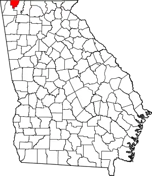 Location within the U.S. state of Georgia | |
 Georgia's location within the U.S. | |
| Coordinates: 34°54′N 85°08′W | |
| Country | |
| State | |
| Founded | 1853 |
| Seat | Ringgold |
| Largest city | Fort Oglethorpe |
| Area | |
| • Total | 162 sq mi (420 km2) |
| • Land | 162 sq mi (420 km2) |
| • Water | 0.3 sq mi (0.8 km2) 0.27%% |
| Population | |
| • Estimate (2019) | 67,580 |
| • Density | 394/sq mi (152/km2) |
| Time zone | UTC−5 (Eastern) |
| • Summer (DST) | UTC−4 (EDT) |
| Congressional district | 14th |
| Website | www |
Catoosa County is part of the Chattanooga, TN–GA Metropolitan Statistical Area.
On April 27, 2011, a devastating tornado touched down in the town of Ringgold, located in Catoosa County, leaving a path of severe destruction.[4]
Geography
According to the U.S. Census Bureau, the county has a total area of 162 square miles (420 km2), of which 162 square miles (420 km2) is land and 0.3 square miles (0.78 km2) (0.2%) is water.[5] The entire county is located in the Middle Tennessee-Chickamauga sub-basin of the Middle Tennessee-Hiwassee basin.[6]
Major highways
 Interstate 75
 U.S. Route 27
 U.S. Route 41
 U.S. Route 76
 State Route 1
 State Route 2
 State Route 3
 State Route 146
 State Route 151
 State Route 401 (unsigned designation for I-75)
Adjacent counties
- Hamilton County, Tennessee (north)
- Whitfield County (east)
- Walker County (west)
National protected areas
Demographics
| Historical population | |||
|---|---|---|---|
| Census | Pop. | %± | |
| 1860 | 5,082 | — | |
| 1870 | 4,409 | −13.2% | |
| 1880 | 4,739 | 7.5% | |
| 1890 | 5,431 | 14.6% | |
| 1900 | 5,823 | 7.2% | |
| 1910 | 7,184 | 23.4% | |
| 1920 | 6,677 | −7.1% | |
| 1930 | 9,421 | 41.1% | |
| 1940 | 12,199 | 29.5% | |
| 1950 | 15,146 | 24.2% | |
| 1960 | 21,101 | 39.3% | |
| 1970 | 28,271 | 34.0% | |
| 1980 | 36,991 | 30.8% | |
| 1990 | 42,464 | 14.8% | |
| 2000 | 53,282 | 25.5% | |
| 2010 | 63,942 | 20.0% | |
| 2019 (est.) | 67,580 | [7] | 5.7% |
| U.S. Decennial Census[8] 1790-1960[9] 1900-1990[10] 1990-2000[11] 2010-2019[1] | |||
2000 census
As of the census[12] of 2000, there were 53,282 people, 20,425 households, and 15,400 families living in the county. The population density was 328 people per square mile (127/km2). There were 21,794 housing units at an average density of 134 per square mile (52/km2). The racial makeup of the county was 96.39% White, 1.26% Black or African American, 0.31% Native American, 0.71% Asian, 0.02% Pacific Islander, 0.39% from other races, and 0.93% from two or more races. 1.17% of the population were Hispanic or Latino of any race.
There were 20,425 households, of which 35.40% had children under the age of 18 living with them, 60.60% were married couples living together, 11.00% had a female householder with no husband present, and 24.60% were non-families. 21.30% of all households were made up of individuals, and 8.50% had someone living alone who was 65 years of age or older. The average household size was 2.59 and the average family size was 3.00.
In the county, the population was spread out, with 25.80% under the age of 18, 8.10% from 18 to 24, 30.80% from 25 to 44, 23.40% from 45 to 64, and 11.90% who were 65 years of age or older. The median age was 36 years. For every 100 females there were 93.80 males. For every 100 females age 18 and over, there were 90.20 males.
The median income for a household in the county was $39,998, and the median income for a family was $45,710. Males had a median income of $31,746 versus $23,790 for females. The per capita income for the county was $18,009. About 6.40% of families and 9.40% of the population were below the poverty line, including 12.50% of those under age 18 and 11.00% of those age 65 or over.
2010 census
As of the 2010 United States Census, there were 63,942 people, 24,475 households, and 17,785 families living in the county.[13] The population density was 394.3 inhabitants per square mile (152.2/km2). There were 26,606 housing units at an average density of 164.1 per square mile (63.4/km2).[14] The racial makeup of the county was 93.6% white, 2.2% black or African American, 1.2% Asian, 0.3% American Indian, 0.1% Pacific islander, 1.0% from other races, and 1.6% from two or more races. Those of Hispanic or Latino origin made up 2.3% of the population.[13][15]
Of the 24,475 households, 36.3% had children under the age of 18 living with them, 55.7% were married couples living together, 12.6% had a female householder with no husband present, 27.3% were non-families, and 23.1% of all households were made up of individuals. The average household size was 2.59 and the average family size was 3.05. The median age was 38.3 years.[13]
The median income for a household in the county was $46,544 and the median income for a family was $54,796. Males had a median income of $39,962 versus $31,505 for females. The per capita income for the county was $22,563. About 8.5% of families and 11.2% of the population were below the poverty line, including 14.8% of those under age 18 and 9.0% of those age 65 or over.[16]
2016
As of 2016 the largest self-reported ancestry groups in Catoosa County, Georgia are:[17]
| Largest ancestries (2015) | Percent |
|---|---|
| English | 17.6% |
| "American" | 17.2% |
| Irish | 13.2% |
| German | 11.7% |
| Scottish | 2.6% |
| Italian | 2.3% |
| Dutch | 1.5% |
| Scots-Irish | 1.5% |
| French | 1.5% |
| Polish | 0.8% |
| Welsh | 0.6% |
| Swedish | 0.5% |
| Norwegian | 0.5% |
| Danish | 0.3% |
Education
Catoosa County elementary schools: Battlefield Elementary, Battlefield Primary, Boynton Elementary, Cloud Springs Elementary, Graysville Elementary, Ringgold Elementary, Ringgold Primary, Tiger Creek Elementary, West Side Elementary, and Woodstation Elementary.
Catoosa County middle schools: Heritage Middle School, Lakeview Middle School, and Ringgold Middle School.
Catoosa County high schools: Heritage High School, Lakeview-Fort Oglethorpe High School, Performance Learning Center, and Ringgold High School.
Communities
Cities
Town
Census-designated places
Other unincorporated communities
Politics
| Year | Republican | Democratic | Third parties |
|---|---|---|---|
| 2020 | 77.2% 25,167 | 21.3% 6,932 | 1.5% 494 |
| 2016 | 77.5% 20,876 | 17.7% 4,771 | 4.8% 1,293 |
| 2012 | 75.1% 17,858 | 22.6% 5,365 | 2.4% 568 |
| 2008 | 74.0% 18,218 | 24.5% 6,025 | 1.5% 362 |
| 2004 | 73.4% 16,406 | 26.0% 5,807 | 0.6% 128 |
| 2000 | 67.9% 12,033 | 30.9% 5,470 | 1.2% 218 |
| 1996 | 55.9% 8,237 | 35.2% 5,185 | 8.9% 1,317 |
| 1992 | 51.6% 7,599 | 32.7% 4,817 | 15.7% 2,315 |
| 1988 | 72.0% 9,319 | 27.7% 3,588 | 0.3% 33 |
| 1984 | 71.9% 7,908 | 28.1% 3,089 | |
| 1980 | 53.9% 5,962 | 44.5% 4,921 | 1.6% 176 |
| 1976 | 38.7% 3,799 | 61.3% 6,020 | |
| 1972 | 87.1% 6,008 | 13.0% 894 | |
| 1968 | 21.8% 2,043 | 9.6% 901 | 68.7% 6,449 |
| 1964 | 58.6% 4,143 | 41.3% 2,922 | 0.1% 6 |
| 1960 | 49.5% 2,074 | 50.5% 2,114 | |
| 1956 | 38.2% 1,336 | 61.8% 2,163 | |
| 1952 | 38.1% 1,371 | 61.9% 2,227 | |
| 1948 | 17.4% 268 | 68.3% 1,051 | 14.2% 219 |
| 1944 | 21.4% 395 | 78.6% 1,453 | |
| 1940 | 14.7% 249 | 85.3% 1,440 | |
| 1936 | 17.6% 218 | 82.2% 1,018 | 0.2% 3 |
| 1932 | 11.0% 123 | 88.2% 985 | 0.8% 9 |
| 1928 | 51.8% 605 | 48.2% 562 | |
| 1924 | 26.0% 242 | 70.9% 661 | 3.1% 29 |
| 1920 | 37.5% 33 | 62.5% 55 | |
| 1916 | 24.3% 210 | 72.1% 624 | 3.7% 32 |
| 1912 | 24.5% 113 | 61.9% 286 | 13.6% 63 |
See also
References
- "State & County QuickFacts". United States Census Bureau. Archived from the original on July 8, 2011. Retrieved June 19, 2014.
- "Find a County". National Association of Counties. Archived from the original on May 31, 2011. Retrieved June 7, 2011.
- "Catoosa County". Calhoun Times. September 1, 2004. p. 25. Retrieved April 24, 2015.
- Ringgold, GA Tornado Confirmed as an EF-4 Tornado, The OKCStormWatcher Weather Blog, April 29, 2011. Retrieved April 30, 2011.
- "US Gazetteer files: 2010, 2000, and 1990". United States Census Bureau. February 12, 2011. Retrieved April 23, 2011.
- "Georgia Soil and Water Conservation Commission Interactive Mapping Experience". Georgia Soil and Water Conservation Commission. Retrieved November 17, 2015.
- "Population and Housing Unit Estimates". Retrieved May 21, 2020.
- "U.S. Decennial Census". United States Census Bureau. Retrieved June 17, 2014.
- "Historical Census Browser". University of Virginia Library. Retrieved June 19, 2014.
- "Population of Counties by Decennial Census: 1900 to 1990". United States Census Bureau. Retrieved June 19, 2014.
- "Census 2000 PHC-T-4. Ranking Tables for Counties: 1990 and 2000" (PDF). United States Census Bureau. Retrieved June 19, 2014.
- "U.S. Census website". United States Census Bureau. Retrieved May 14, 2011.
- "DP-1 Profile of General Population and Housing Characteristics: 2010 Demographic Profile Data". United States Census Bureau. Archived from the original on February 13, 2020. Retrieved December 27, 2015.
- "Population, Housing Units, Area, and Density: 2010 - County". United States Census Bureau. Archived from the original on February 13, 2020. Retrieved December 27, 2015.
- "DP02 SELECTED SOCIAL CHARACTERISTICS IN THE UNITED STATES – 2006-2010 American Community Survey 5-Year Estimates". United States Census Bureau. Archived from the original on February 13, 2020. Retrieved December 27, 2015.
- "DP03 SELECTED ECONOMIC CHARACTERISTICS – 2006-2010 American Community Survey 5-Year Estimates". United States Census Bureau. Archived from the original on February 13, 2020. Retrieved December 27, 2015.
- Bureau, U.S. Census. "American FactFinder - Results". factfinder.census.gov. Archived from the original on February 13, 2020. Retrieved April 29, 2018.
- Leip, David. "Dave Leip's Atlas of U.S. Presidential Elections". uselectionatlas.org. Retrieved March 19, 2018.
External links
- Official website
- Catoosa county, GA, genealogy
- Catoosa County historical marker
- Old Stone Presbyterian Church historical marker
Places adjacent to Catoosa County, Georgia | ||||||||||
|---|---|---|---|---|---|---|---|---|---|---|
| ||||||||||
Municipalities and communities of Catoosa County, Georgia, United States | ||
|---|---|---|
| Cities | Map of Georgia highlighting Catoosa County | |
| CDPs | ||
| Unincorporated communities | ||
| Footnotes | ‡This populated place also has portions in an adjacent county or counties | |
| ||

| Authority control |
|---|