Seminole County, Georgia
Seminole County is a county located in the southwestern corner of U.S. state of Georgia. As of the 2010 census, the population was 8,729.[1] The county seat is Donalsonville.[2]
Seminole County | |
|---|---|
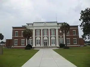 Seminole County Courthouse in Donalsonville | |
 Location within the U.S. state of Georgia | |
 Georgia's location within the U.S. | |
| Coordinates: 30°56′N 84°52′W | |
| Country | |
| State | |
| Founded | November 2, 1920 |
| Named for | Seminole tribe |
| Seat | Donalsonville |
| Largest city | Donalsonville |
| Area | |
| • Total | 257 sq mi (670 km2) |
| • Land | 235 sq mi (610 km2) |
| • Water | 21 sq mi (50 km2) 8.3%% |
| Population | |
| • Estimate (2018) | 8,315 |
| • Density | 37/sq mi (14/km2) |
| Time zone | UTC−5 (Eastern) |
| • Summer (DST) | UTC−4 (EDT) |
| Congressional district | 2nd |
| Website | www |
History
The state constitutional amendment to create the county was proposed July 8, 1920, and ratified November 2, 1920. The area for the new county was taken from land which was originally part of Decatur and Early counties. It is named for the Seminole tribe of Native Americans, who once lived in the Chattahoochee River basin within the county, before European settlement forced their move to the Florida everglades. According to legend, the celebrated Seminole chief Osceola was born in what is today Seminole County.[3]
Geography
According to the U.S. Census Bureau, the county has a total area of 257 square miles (670 km2), of which 235 square miles (610 km2) is land and 21 square miles (54 km2) (8.3%) is water.[4]
The bulk of Seminole County is located in the Spring Creek sub-basin of the ACF River Basin (Apalachicola-Chattahoochee-Flint River Basin). The county's entire western border with Florida is located in the Lower Chattahoochee River sub-basin of the same ACF River Basin. A tiny southeastern corner of Seminole County, all part of Lake Seminole, is located in the Lower Flint River sub-basin of the same larger ACF River Basin. It is the only county in Georgia that borders both Alabama and Florida.[5]
Major highways
Adjacent counties
- Miller County (northeast)
- Decatur County (east)
- Jackson County, Florida (southwest)
- Houston County, Alabama (northwest)
- Early County (north-northwest)
Demographics
| Historical population | |||
|---|---|---|---|
| Census | Pop. | %± | |
| 1930 | 7,389 | — | |
| 1940 | 8,492 | 14.9% | |
| 1950 | 7,904 | −6.9% | |
| 1960 | 6,802 | −13.9% | |
| 1970 | 7,059 | 3.8% | |
| 1980 | 9,057 | 28.3% | |
| 1990 | 9,010 | −0.5% | |
| 2000 | 9,369 | 4.0% | |
| 2010 | 8,729 | −6.8% | |
| 2018 (est.) | 8,315 | [6] | −4.7% |
| U.S. Decennial Census[7] 1790-1960[8] 1900-1990[9] 1990-2000[10] 2010-2013[1] | |||
2000 census
As of the census[11] of 2000, there were 9,369 people, 3,573 households, and 2,597 families living in the county. The population density was 39 people per square mile (15/km2). There were 4,742 housing units at an average density of 20 per square mile (8/km2). The racial makeup of the county was 61.75% White, 34.66% Black or African American, 0.18% Native American, 0.18% Asian, 2.79% from other races, and 0.45% from two or more races. 3.70% of the population were Hispanic or Latino of any race.
There were 3,573 households, out of which 29.90% had children under the age of 18 living with them, 51.10% were married couples living together, 17.90% had a female householder with no husband present, and 27.30% were non-families. 24.30% of all households were made up of individuals, and 11.50% had someone living alone who was 65 years of age or older. The average household size was 2.54 and the average family size was 3.01.
In the county, the population was spread out, with 26.20% under the age of 18, 8.60% from 18 to 24, 26.40% from 25 to 44, 23.00% from 45 to 64, and 15.80% who were 65 years of age or older. The median age was 38 years. For every 100 females there were 91.00 males. For every 100 females age 18 and over, there were 86.60 males.
The median income for a household in the county was $27,094, and the median income for a family was $33,221. Males had a median income of $25,909 versus $20,194 for females. The per capita income for the county was $14,635. About 15.80% of families and 23.20% of the population were below the poverty line, including 35.10% of those under age 18 and 18.60% of those age 65 or over.
2010 census
As of the 2010 United States Census, there were 8,729 people, 3,509 households, and 2,471 families living in the county.[12] The population density was 37.1 inhabitants per square mile (14.3/km2). There were 4,797 housing units at an average density of 20.4 per square mile (7.9/km2).[13] The racial makeup of the county was 63.2% white, 33.1% black or African American, 0.4% Asian, 0.1% American Indian, 0.1% from other races, and 0.8% from two or more races. Those of Hispanic or Latino origin made up 2.3% of the population.[12] In terms of ancestry, 34.8% were American, 12.6% were Irish, and 6.0% were English.[14]
Of the 3,509 households, 30.4% had children under the age of 18 living with them, 47.8% were married couples living together, 17.9% had a female householder with no husband present, 29.6% were non-families, and 26.4% of all households were made up of individuals. The average household size was 2.46 and the average family size was 2.95. The median age was 43.7 years.[12]
The median income for a household in the county was $32,666 and the median income for a family was $38,339. Males had a median income of $33,965 versus $23,896 for females. The per capita income for the county was $19,263. About 19.3% of families and 25.4% of the population were below the poverty line, including 37.2% of those under age 18 and 15.7% of those age 65 or over.[15]
Communities
- Desser
- Donalsonville (county seat)
- Iron City
- Little Hope
- Reynoldsville
Politics
| Year | Republican | Democratic | Third parties |
|---|---|---|---|
| 2020 | 67.2% 2,611 | 32.3% 1,254 | 0.5% 19 |
| 2016 | 65.4% 2,345 | 33.1% 1,189 | 1.5% 54 |
| 2012 | 59.4% 2,245 | 39.1% 1,478 | 1.4% 54 |
| 2008 | 57.8% 2,315 | 41.4% 1,660 | 0.8% 32 |
| 2004 | 60.3% 1,977 | 39.0% 1,278 | 0.8% 26 |
| 2000 | 53.4% 1,537 | 45.6% 1,313 | 0.9% 27 |
| 1996 | 39.7% 1,003 | 50.1% 1,265 | 10.1% 256 |
| 1992 | 33.7% 850 | 47.4% 1,193 | 18.9% 476 |
| 1988 | 55.5% 1,469 | 44.3% 1,171 | 0.2% 5 |
| 1984 | 54.8% 1,636 | 45.2% 1,350 | |
| 1980 | 38.0% 1,117 | 61.1% 1,794 | 0.9% 25 |
| 1976 | 24.7% 681 | 75.3% 2,074 | |
| 1972 | 83.1% 1,851 | 16.9% 376 | |
| 1968 | 8.1% 201 | 14.8% 370 | 77.1% 1,922 |
| 1964 | 75.2% 1,294 | 24.8% 427 | |
| 1960 | 4.7% 77 | 95.4% 1,579 | |
| 1956 | 8.8% 129 | 91.2% 1,343 | |
| 1952 | 13.5% 176 | 86.5% 1,126 | |
| 1948 | 11.7% 105 | 80.3% 722 | 8.0% 72 |
| 1944 | 7.2% 83 | 92.8% 1,076 | |
| 1940 | 6.1% 58 | 93.5% 884 | 0.4% 4 |
| 1936 | 9.7% 82 | 90.3% 761 | |
| 1932 | 2.5% 20 | 96.3% 776 | 1.2% 10 |
| 1928 | 22.9% 110 | 77.1% 371 | |
| 1924 | 9.8% 24 | 82.0% 201 | 8.2% 20 |
References
- "State & County QuickFacts". United States Census Bureau. Retrieved June 26, 2014.
- "Find a County". National Association of Counties. Retrieved June 7, 2011.
- "History of Seminole County" (PDF). Seminole County Board of Commissioners. Retrieved November 30, 2018.
- "US Gazetteer files: 2010, 2000, and 1990". United States Census Bureau. February 12, 2011. Retrieved April 23, 2011.
- "Georgia Soil and Water Conservation Commission Interactive Mapping Experience". Georgia Soil and Water Conservation Commission. Retrieved November 24, 2015.
- "Population and Housing Unit Estimates". Retrieved July 31, 2019.
- "U.S. Decennial Census". United States Census Bureau. Retrieved June 26, 2014.
- "Historical Census Browser". University of Virginia Library. Retrieved June 26, 2014.
- "Population of Counties by Decennial Census: 1900 to 1990". United States Census Bureau. Retrieved June 26, 2014.
- "Census 2000 PHC-T-4. Ranking Tables for Counties: 1990 and 2000" (PDF). United States Census Bureau. Retrieved June 26, 2014.
- "U.S. Census website". United States Census Bureau. Retrieved January 31, 2008.
- "DP-1 Profile of General Population and Housing Characteristics: 2010 Demographic Profile Data". United States Census Bureau. Archived from the original on February 13, 2020. Retrieved December 30, 2015.
- "Population, Housing Units, Area, and Density: 2010 - County". United States Census Bureau. Archived from the original on February 13, 2020. Retrieved December 30, 2015.
- "DP02 SELECTED SOCIAL CHARACTERISTICS IN THE UNITED STATES – 2006-2010 American Community Survey 5-Year Estimates". United States Census Bureau. Archived from the original on February 13, 2020. Retrieved December 30, 2015.
- "DP03 SELECTED ECONOMIC CHARACTERISTICS – 2006-2010 American Community Survey 5-Year Estimates". United States Census Bureau. Archived from the original on February 13, 2020. Retrieved December 30, 2015.
- Leip, David. "Dave Leip's Atlas of U.S. Presidential Elections". uselectionatlas.org. Retrieved March 22, 2018.
External links
- Official Website of Donalsonville-Seminole County Chamber of Commerce Includes the City of Donalsoville and Iron City
- Seminole County School System Includes the City of Donalsonville, Iron, and Entirely Seminole County
- Seminole County Clerk of Court
Places adjacent to Seminole County, Georgia | ||||||||||
|---|---|---|---|---|---|---|---|---|---|---|
| ||||||||||
Municipalities and communities of Seminole County, Georgia, United States | ||
|---|---|---|
| City | Map of Georgia highlighting Seminole County | |
| Town | ||
| Unincorporated communities |
| |
| Former communities |
| |
| ||

| Authority control |
|---|