East Chicago, Indiana
East Chicago is a city in Lake County, Indiana, United States. The population was 29,698 at the 2010 census. It is the home of Marktown, Clayton Mark's planned worker community.[9]
East Chicago, Indiana | |
|---|---|
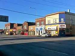 Indianapolis Blvd | |
 Seal | |
| Nicknames: Indiana Harbor, The Harbor, E.C., The Twin City (East Chicago & Indiana Harbor neighborhoods – used in the early 1900s). | |
| Motto(s): "Progredemur" (We Progress) and A City of Hope and Progress | |
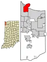 Location of East Chicago in Lake County, Indiana. | |
| Coordinates: 41°38′20″N 87°27′44″W | |
| Country | |
| State | |
| County | Lake |
| Township | North |
| Incorporated (Town) | 1889[1] |
| Incorporated (City) | 1893[1] |
| Government | |
| • Type | Mayor-Council |
| • Mayor | Anthony Copeland (D) |
| • City Council | |
| • City Clerk | Adrian A. Santos (D) |
| • City Judge | Sonya Morris (D) |
| Area | |
| • Total | 16.16 sq mi (41.85 km2) |
| • Land | 14.09 sq mi (36.50 km2) |
| • Water | 2.07 sq mi (5.35 km2) |
| Elevation | 591 ft (180 m) |
| Population | |
| • Total | 29,698 |
| • Estimate (2019)[5] | 27,817 |
| • Density | 1,973.68/sq mi (762.04/km2) |
| Standard of living (2008-12) | |
| • Per capita income | $13,457 |
| • Median home value | $86,800 |
| Time zone | UTC-6 (Central) |
| • Summer (DST) | UTC-5 (Central) |
| ZIP code | 46312 |
| Area code | 219 |
| FIPS code | 18-19486[6] |
| GNIS feature ID | 0433875[7] |
| Interstate, U.S. and State Routes | |
| Waterways | Grand Calumet River Indiana Harbor and Ship Canal Lake Michigan |
| South Shore Line station | East Chicago
|
| Public transit | East Chicago Transit |
| Website | www.eastchicago.com |
| Demographics (2010)[8] | |||
|---|---|---|---|
| White | Black | Asian | |
| 35.5% | 42.9% | 0.1% | |
| Islander | Native | Other | Hispanic (any race) |
| 0.0% | 0.6% | 20.9% | 50.9% |
| Historical population | |||
|---|---|---|---|
| Census | Pop. | %± | |
| 1890 | 1,255 | — | |
| 1900 | 3,411 | 171.8% | |
| 1910 | 19,098 | 459.9% | |
| 1920 | 35,967 | 88.3% | |
| 1930 | 54,784 | 52.3% | |
| 1940 | 54,637 | −0.3% | |
| 1950 | 54,263 | −0.7% | |
| 1960 | 57,669 | 6.3% | |
| 1970 | 46,982 | −18.5% | |
| 1980 | 39,786 | −15.3% | |
| 1990 | 33,892 | −14.8% | |
| 2000 | 32,414 | −4.4% | |
| 2010 | 29,698 | −8.4% | |
| 2019 (est.) | 27,817 | [5] | −6.3% |
| Source: US Census Bureau | |||
History
The land that became East Chicago was originally swampland unsuitable for farming. The state of Indiana began selling off plots of land to railroads and speculators after 1851 to fund the local school system. Settlement of the area was very slow at first, and as late as the 1890s, the city had no proper streets or public utilities.[10] East Chicago was incorporated as a city in 1893. The city was named from its location east of Chicago, Illinois.[11]
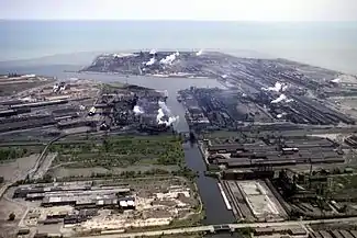
The 1900 Census gives a total population of just 3,411, but the arrival of the Inland Steel Corporation in 1903 transformed the city into an industrial powerhouse. The city's population skyrocketed to over 24,000 by 1910, powered by immigration from all over Europe and the United States, and quickly became the most industrialized city in the United States, with over 80% of the city's land zoned for heavy industry. The Inland Steel corporation would dominate the city's economy through the 1990s, and expanded its massive integrated mill at Indiana Harbor multiple times through the 1980s. From 60,000 tons of steel capacity in 1903, it expanded to 600,000 tons by 1914 and reached 1 million in 1917, and eventually peaked at 8.6 million tons in 1978.[12] By 1907, East Chicago boasted a navigable waterway link to Lake Michigan and to the Grand Calumet River: the Indiana Harbor Ship Canal. Steel mills, petroleum refineries, construction firms, and chemical factories operated at Indiana Harbor and along its inner canal system.[13]
Republic Steel, Youngstown Steel, LaSalle Steel, and U.S. Steel all eventually had steel-making operations in the city. During World War I, East Chicago was nicknamed the "Arsenal of America" (not to be confused with Detroit's label as the "Arsenal of Democracy" during WWII) and the "Workshop of America".[14]
A rivalry developed between Indiana Harbor, the “East Side” home of Inland Steel and most working-class families, and East Chicago's “West Side,” the residential enclave of the native-born business community. Locals spoke of the “Twin City” to describe spatial, residential, and class divisions at the heart of the town's identity. The "Twin City" moniker remains to this day.[13]
During the 1910s, several thousand Mexicans immigrated to East Chicago to work in the mills during the labor shortage of 1917-1918 due to U.S. participation in World War I, and also acted as strike breakers during labor unrest in 1919. Most were single men who eventually hoped to return to Mexico, but many stayed on and eventually were joined by their families. The small Mexican community was targeted for voluntary and forced repatriation during the 1930s and 1950s (1,800 were deported in 1932 alone), but those who remained eventually paved the way for later Latino immigration after 1965.
Black Americans also began to arrive in the 1910s and 1920s as part of the first wave of the Great Migration, and this continued from the 1940s to 1960s. According to a city demographic survey in 1959, there were 1,000 Mexican families, 10,000 African American families, along with 3,000 Polish families. There were also a large number of families that identified as Puerto Rican, Romanian, Serbian, Italian, Lithuanian and Croatian. Over 70 nationalities were represented, with over 59 congregations of the Protestants, Orthodox, Catholic Churches, as well as Jewish synagogues.
Like neighboring Gary, Indiana, East Chicago quickly developed a reputation as a rough industrial city, plagued by extreme pollution, ethnic and racial tensions, organized crime, illegal gambling & clubs, political corruption, prostitution, and other vices. The city continued to rapidly grow in the 1910s and 1920s, and the population peaked in 1960 at 57,669. However, East Chicago's population began to decline in the 1960s as suburbanization, white flight, affordability of automobiles, and the construction of highways meant that workers no longer had to live in the city, but could commute from less-polluted suburbs.
But it was the steel crisis of the 1974-1986 period that completely devastated East Chicago, as it did other industrial cities like Gary, Cleveland, Pittsburgh, and the south side of Chicago. East Chicago's population plunged to 47,000 in 1970, 34,000 by 1990, and 29,000 by 2010. Employment at Inland Steel peaked at 25,000 in 1969, and successive layoffs over the next 30 years were devastating to the community; by 1998, only 9,000 were employed at Inland Steel.[15] Inland Steel was acquired by Ispat International in 1998,[16] and both the Indiana Harbor mill and Youngstown Steel mill were absorbed by ArcelorMittal in 2006.[17]
The Indiana Harbor Public Library and Marktown Historic District are listed in the National Register of Historic Places.[18]
In 2009, parts of East Chicago were discovered to have toxic lead and arsenic contamination, designated the USS Lead Superfund Site. The site is divided into three zones, with public housing and residential properties.[19] Residents' decades-long concerns about lead contamination were confirmed in 2016 via EPA testing, especially affecting over 270 families in the West Calumet Housing Complex.[20][21] As Governor of Indiana, Mike Pence declined to declare the Superfund site a state emergency;[22] his successor Governor Eric Holcomb has issued Executive Order 17-13, declaring a disaster emergency in East Chicago.[23][24]
Geography
According to the 2010 census, East Chicago has a total area of 16.155 square miles (41.84 km2), of which 14.09 square miles (36.49 km2) (or 87.22%) is land and 2.065 square miles (5.35 km2) (or 12.78%) is water.[25]
Demographics
2010 census
As of the census[4] of 2010, there were 29,698 people, 10,724 households, and 7,197 families residing in the city. The population density was 2,107.7 inhabitants per square mile (813.8/km2). There were 12,958 housing units at an average density of 919.7 per square mile (355.1/km2). The racial makeup of the city was 42.9% African American, 35.5% White, 0.6% Native American, 0.1% Asian, 18.1% from other races, and 2.8% from two or more races. Hispanic or Latino of any race were 50.9% of the population.
There were 10,724 households, of which 40.8% had children under the age of 18 living with them, 27.9% were married couples living together, 31.4% had a female householder with no husband present, 7.7% had a male householder with no wife present, and 32.9% were non-families. 29.0% of all households were made up of individuals, and 9.5% had someone living alone who was 65 years of age or older. The average household size was 2.75 and the average family size was 3.42.
The median age in the city was 30.9 years. 31.4% of residents were under the age of 18; 9.7% were between the ages of 18 and 24; 25.4% were from 25 to 44; 22.2% were from 45 to 64; and 11.3% were 65 years of age or older. The gender makeup of the city was 46.8% male and 53.2% female.
2000 census
As of the census[6] of 2000, there were 32,414 people, 11,707 households, and 7,937 families residing in the city. The population density was 2,706.3 people per square mile (1,044.7/km2). There were 13,261 housing units at an average density of 1,107.2 per square mile (427.4/km2). The racial makeup of the city was 36.54% White, 36.08% African American, 0.51% Native American, 0.20% Asian, 0.08% Pacific Islander, 23.98% from other races, and 2.60% from two or more races. Hispanic or Latino of any race were 51.61% of the population. Whites who are not Hispanic or Latino were 12.10% of the city's population. 54.3% spoke only English at home, while 42.9% Spanish and 1.2% Polish at home.
There were 11,707 households, out of which 35.6% had children under the age of 18 living with them, 34.8% were married couples living together, 26.7% had a female householder with no husband present, and 32.2% were non-families. 28.6% of all households were made up of individuals, and 11.2% had someone living alone who was 65 years of age or older. The average household size was 2.75 and the average family size was 3.41.
In the city, the population was spread out, with 30.5% under the age of 18, 11.1% from 18 to 24, 26.8% from 25 to 44, 18.3% from 45 to 64, and 13.3% who were 65 years of age or older. The median age was 31 years. For every 100 females, there were 91.7 males. For every 100 females age 18 and over, there were 86.1 males.
The median income for a household in the city was $26,538, and the median income for a family was $31,778. Males had a median income of $32,588 versus $21,678 for females. The per capita income for the city was $13,517. About 22.5% of families and 24.4% of the population were below the poverty line, including 33.3% of those under age 18 and 15.6% of those age 65 or over.
Transportation
The nearest commercial airport to East Chicago is the Gary/Chicago International Airport in neighboring Gary, but it does not have any scheduled passenger service. The closest commercial airport with scheduled passenger service is Chicago Midway Airport.
The South Shore Line has a station in East Chicago.
US 12 and US 20 go through the Indiana Harbor and East Chicago sections of the city, respectively, before joining up on both sides. Indiana State Road 912, the Cline Avenue Expressway, connects East Chicago with the Indiana Toll Road and Borman Expressway, and serves the casino and steel mills on the lakefront.
Bus transit
The city operates a free bus service known as East Chicago Transit. It features three routes: Crosstown, West Calumet, and Griffith Plaza.[26] GPRT Route R1 stops in East Chicago en route from Hammond to Gary. PACE operates Route 892, a special work shuttle between Gary, East Chicago and UPS' Hodgkins facility. Its schedule coincides with UPS workers' shifts. The route is operated in cooperation with UPS, which partially funds its operations.
Neighborhoods
Education
- School City of East Chicago serves the city. All residents are zoned to East Chicago Central High School.
- Ivy Tech community college
East Chicago Public Library System operates a main library at 2401 East Columbus Drive and the Robert A. Pastrick Branch Library at 1008 West Chicago Avenue at Baring Avenue.[27] East Chicago also has two charter school options, East Chicago Urban Enterprise (K-8), and East Chicago Lighthouse Charter School (K-7).
Industry
East Chicago is home to the following business and industry:
- ArcelorMittal's Indiana Harbor Works, the largest steel mill in the USA. Indiana Harbor Works comprises East mill, originally Inland Steel, and West mill, owned for most of its life by Youngstown Sheet and Tube.[28]
- U.S. Steel’s East Chicago Tin, a steel finishing faculty part of Gary Works.[29]
- The Indiana Harbor and Ship Canal complex.
For 105 years, East Chicago was home to the Inland Steel Company (1893–1998).
The Showboat Casino opened in 1997 with about 900 employees. Other large employers include Amoco Oil Co., Union Tank Car, American Steel Foundries, USG Corp. and St. Catherine Hospital.
Notable people
- Government
- Gonzalo P. Curiel - US District Court judge
- Earl Harris - Indiana state legislator
- William C. Kavanaugh - Wisconsin State Assemblyman
- Vincent Mroz - Secret Service agent
- Jerome Reppa - Indiana lawyer and politician
- Richard Williams - diplomat, author, first US ambassador to Mongolia
- Military
- Emilio A. De La Garza, Jr. - U.S. Marine Corps, Medal of Honor recipient, Vietnam War
- Alexander Vraciu - U.S. Navy, Navy Cross, leading flying ace during World War II
- Movies - TV
- John Hubbard - actor
- Betsy Palmer - actress and television personality
- Frank Reynolds - ABC television news anchorman
- Steve Tesich - Academy Award-winning screenwriter
- Music
- Catfish Keith - blues singer, songwriter and slide guitarist
- Mighty Mo Rodgers - blues musician, songwriter and record producer
- Sports
- Thomas Yohe (football) - notable quarterback in the European football league. 3-time Harvard quarterback of the year 1987-1988. 3-time Emmy's winner for his work as a sport TV director.
- Bob Anderson - Major League Baseball player
- Jim Bradley - professional basketball player
- Junior Bridgeman - NBA player for Milwaukee Bucks and businessman; jersey number retired by Bucks
- Larry Fritz - Major League Baseball player
- Jim Hicks - Major League Baseball player
- Danny Lazar - Major League Baseball pitcher
- Kenny Lofton - Major League Baseball player, 6-time All-Star, 4-time Gold Glove winner
- Angel Manfredy - professional boxer/title holder
- Monica Maxwell - professional basketball player
- E'Twaun Moore - professional basketball player
- Ilie Oană - football player and manager who represented and coached Romania national football team
- Frank Patrick - professional football player
- Stan Perzanowski - MLB pitcher
- Bridget Pettis - professional basketball player and coach
- Gregg Popovich - coach of San Antonio Spurs, 5-time NBA champion, 3-time NBA Coach of the Year
- Jason Repko - Major League Baseball outfielder for Boston Red Sox and Los Angeles Dodgers
- Kawann Short - Carolina Panthers professional football player
- Matt Smith - sports radio personality
- Ron Smith - NFL player
- Tim Stoddard - Major League Baseball pitcher and college basketball player, forward for NC State's 1974 NCAA basketball champions
- Pete Trgovich—played on 1971 Washington HS Indiana state championship team with Junior Bridgeman and Tim Stoddard, went on to play for legendary coach John Wooden at UCLA, winning 3 NCAA Championship rings
- Ray Wietecha - assistant coach to Vince Lombardi and NFL champion Green Bay Packers
- Other
- Cliff Raven - tattoo artist
- Miguel Torres - mixed martial artist
- David Albin Zywiec Sidor - American-Nicaraguan Roman Catholic bishop
- Reggie Martin - Entertainment Celebrity who has The Key To The City[30]
References
- "East Chicago, Indiana". Encyclopedia of Chicago. Retrieved 2014-10-16.
- "2014 Public Officials Directory". Lake County Board of Elections and Voter's Registration. Retrieved 2014-06-10.
- "2019 U.S. Gazetteer Files". United States Census Bureau. Retrieved July 16, 2020.
- "U.S. Census website". United States Census Bureau. Retrieved 2014-06-09.
- "Population and Housing Unit Estimates". United States Census Bureau. May 24, 2020. Retrieved May 27, 2020.
- "U.S. Census website". United States Census Bureau. Retrieved 2008-01-31.
- "US Board on Geographic Names". United States Geological Survey. 2007-10-25. Retrieved 2008-01-31.
- U.S. Census Bureau. American Community Survey, Profile of General Population and Housing Characteristics 2010, Table DP-1, 2010 Demographic Profile Data. U.S. Census website . Retrieved 2014-06-30.
- Smith, Stephanie; Mark, Steve (2011). "Marktown: Clayton Mark's Planned Worker Community in Northwest Indiana". South Shore Journal. 4. Archived from the original on 2012-09-13.
- "East Chicago: From Swampland to Industrial Hub". The Times of Northwest Indiana. Tribune. Retrieved 30 July 2018.
- Baker, Ronald L. (October 1995). From Needmore to Prosperity: Hoosier Place Names in Folklore and History. Indiana University Press. p. 120. ISBN 978-0-253-32866-3.
...as the city is located east of Chicago...
- "Inland Steel History". NWI Steel Heritage Museum. Retrieved 30 July 2018.
- "East Chicago, IN". The Encyclopedia of Chicago. Retrieved 30 July 2018.
- "History of Our City". City of East Chicago. City of East Chicago. Retrieved 30 July 2018.
- "East Chicago residents can be forgiven for cheering the..." Chicago Tribune. Chicago Tribune. Retrieved 30 July 2018.
- "Ispat completes Inland Steel deal". Northwest Indiana Times. Jul 18, 1998. Retrieved 6 October 2018.
- "Indiana Harbor Works Steel Plant, Indiana". Land Use Database. Center for Land Use Interpretation. Retrieved 6 October 2018.
- "National Register Information System". National Register of Historic Places. National Park Service. July 9, 2010.
- 05, OEC, US EPA, REG. "USS Lead Superfund Site". www.epa.gov. Retrieved 2017-02-23.
- 05, OEC, US EPA, REG. "West Calumet Housing Complex – East Chicago, Ind". www.epa.gov. Retrieved 2017-02-23.
- Janzen, Nick (2016-09-02). "East Chicago Residents Scramble For Info After Lead Found In Soil". WFYI Public Media. Retrieved 2017-02-23.
- Erbentraut, Joseph (2017-02-16). "Mike Pence Ignored A Lead Contamination Crisis In His Backyard". The Huffington Post. Retrieved 2017-02-23.
- "Governor Holcomb: Executive Orders". www.in.gov. Retrieved 2017-02-23.
- "East Chicago Lead Crisis Declared Emergency by Indiana Governor". Patch. Chicago. 2017-02-10. Retrieved 2017-02-23.
- "G001 - Geographic Identifiers - 2010 Census Summary File 1". United States Census Bureau. Archived from the original on 2020-02-13. Retrieved 2015-07-28.
- "Route Maps | East Chicago, IN". East Chicago Bus Transit. Retrieved 2021-02-02.
- "About ECPL Archived 2009-03-28 at the Wayback Machine." East Chicago Public Library. Retrieved on January 21, 2009.
- "Indiana Harbor". Facilities: Americas. ArcelorMittal. Retrieved 9 November 2011.
- "U. S. Steel". ussteel.com. Retrieved 2018-03-23.
- "Biography: Reggie Martin". American Chamber of Commerce in Macau. Retrieved 2020-10-08.
External links
| Wikimedia Commons has media related to East Chicago, Indiana. |
- Official website
- . Encyclopædia Britannica (11th ed.). 1911.
Municipalities and communities of Lake County, Indiana, United States | ||
|---|---|---|
| Cities | Map of Indiana highlighting Lake County | |
| Towns | ||
| Townships | ||
| CDPs | ||
| Other unincorporated communities | ||
| Ghost town | ||
| Footnotes | ‡This populated place also has portions in an adjacent county or counties. | |
| ||
| Major city |  | |
|---|---|---|
| Cities (over 30,000 in 2010) | ||
| Towns and villages (over 30,000 in 2010) |
| |
| Counties | ||
| Regions | ||
| Sub-regions | ||

| Authority control |
|---|