Grade II* listed buildings in Welwyn Hatfield
There are over 20,000 Grade II* listed buildings in England. This page is a list of these buildings in the district of Welwyn Hatfield in Hertfordshire.
Welwyn Hatfield
| Name | Location | Type | Completed [note 1] | Date designated | Grid ref.[note 2] Geo-coordinates |
Entry number [note 3] | Image |
|---|---|---|---|---|---|---|---|
| Ayot House | Ayot St Lawrence, Welwyn Hatfield | House | Early-mid 18th century | 24 January 1967 | TL1946616987 51°50′19″N 0°16′03″W |
1348107 |  |
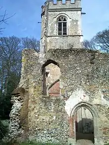
| Old St Lawrence Church | Ayot St. Lawrence, Welwyn Hatfield | Church | 12th century | 24 January 1967 | TL1947616878 51°50′16″N 0°16′02″W |
1101088 | |
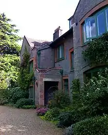
| Shaw's Corner | Ayot St. Lawrence, Welwyn Hatfield | House | c. 1900 | 24 January 1967 | TL1939416657 51°50′09″N 0°16′07″W |
1348110 | |
| Church of St Mary the Virgin | Essendon, Hertfordshire | Church | 15th century | 30 March 1966 | TL2735708763 51°45′47″N 0°09′21″W |
1101071 | 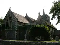 Church of St Mary the Virgin |
| Bridge over the Lake at Brocket Hall | Lemsford, Hatfield, Welwyn Hatfield | Bridge | 1772-4 | 30 March 1966 | TL2146412590 51°47′56″N 0°14′24″W |
1173560 | 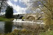 Bridge over the Lake at Brocket Hall |
| Gatehouse to Hatfield House with Porter's Lodge and the 2 Adjoining Cottages on the South | Old Hatfield, Hatfield, Welwyn Hatfield | Lodge | c. 1480 | 30 March 1966 | TL2354708487 51°45′41″N 0°12′40″W |
1173164 | 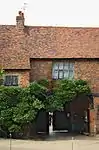 Gatehouse to Hatfield House with Porter's Lodge and the 2 Adjoining Cottages on the South |
| Gates,lodges and Screen Wall at South-east Entrance to Brocket Hall | Lemsford, Hatfield, Welwyn Hatfield | Gate | c. 1765 | 9 December 1983 | TL2162612119 51°47′40″N 0°14′16″W |
1101030 | |
| Goodrich House | Old Hatfield, Hatfield, Welwyn Hatfield | House | Late 18th century | 3 April 1951 | TL2348608547 51°45′43″N 0°12′44″W |
1296264 | 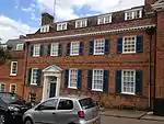 Goodrich House |
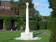
| Hatfield War Memorial | Old Hatfield, Hatfield, Welwyn Hatfield | War memorial | 1921 | 16 May 2017 | TL2330508786 51°45′51″N 0°12′53″W |
1445906 | |
| Hill House | Old Hatfield, Hatfield, Welwyn Hatfield | Double House | c. 1800 | 3 April 1951 | TL2346608730 51°45′49″N 0°12′44″W |
1348182 | |
| The Flight Test Hangar, Offices, Fire Station and Control Tower, British Aerospace | Hatfield, Welwyn Hatfield | Fire Station | 1954 | 21 September 1998 | TL2127308842 51°45′54″N 0°14′39″W |
1376561 | |
| The Old Mill House Museum and Mill Green Mill | Mill Green, Hatfield, Welwyn Hatfield | Mill House | 17th century and earlier | 2 September 1977 | TL2400109774 51°46′22″N 0°12′15″W |
1101037 | |
| The Temple, Brocket Hall | Lemsford, Hatfield, Welwyn Hatfield | Garden Temple | Mid-late 18th century | 30 March 1966 | TL2123413062 51°48′11″N 0°14′35″W |
1100988 | |
| Torilla | Hatfield, Welwyn Hatfield | House | 1934-5 | 23 April 1993 | TL2065207818 51°45′22″N 0°15′12″W |
1348145 | |
| Church of St Mary the Virgin | North Mymms, Welwyn Hatfield | Church | 14th century | 30 March 1966 | TL2212704445 51°43′32″N 0°14′00″W |
1100951 | 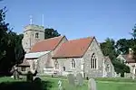 Church of St Mary the Virgin |
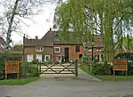
| Moffats Farmhouse | Brookmans Park, North Mymms, Welwyn Hatfield | House | C16/17 | 30 March 1966 | TL2485904146 51°43′20″N 0°11′38″W |
1348175 | |
| The Folly Arch | Brookmans Park, North Mymms, Welwyn Hatfield | Gate | c. 1740 | 6 February 1952 | TL2545803028 51°42′43″N 0°11′08″W |
1100984 | |
| Northaw Place | Northaw, Northaw and Cuffley, Welwyn Hatfield | House | c. 1690 | 6 February 1952 | TL2700002465 51°42′24″N 0°09′48″W |
1100972 | |
| Parish Church of St Thomas a Becket | Northaw, Northaw and Cuffley, Welwyn Hatfield | Church | 1809 | 9 December 1983 | TL2792202312 51°42′18″N 0°09′01″W |
1348170 | 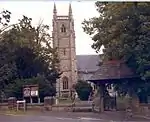 Parish Church of St Thomas a Becket |
| The Dower House | Northaw, Northaw and Cuffley, Welwyn Hatfield | House | Early 19th century | 30 March 1966 | TL2710302259 51°42′17″N 0°09′43″W |
1348167 | |
| Guessens | Welwyn, Welwyn Hatfield | House | c. 1730 | 24 January 1967 | TL2305716294 51°49′54″N 0°12′56″W |
1100961 | |
| Sherardswood School, Lockleys | Welwyn, Welwyn Hatfield | Country House | 1717 | 24 January 1967 | TL2369415941 51°49′42″N 0°12′23″W |
1100925 | |
| Welwyn Railway Viaduct (Digswell Viaduct) | Welwyn, Welwyn Hatfield | Railway Viaduct | 1848-50 | 4 November 1980 | TL2452514852 51°49′06″N 0°11′41″W |
1348122 | 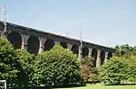 Welwyn Railway Viaduct (Digswell Viaduct) |
| Templewood Primary School | Welwyn Hatfield | Elementary School | 1950 | 30 March 1993 | TL2355813885 51°48′36″N 0°12′33″W |
1101085 | |
.jpg.webp)
.jpg.webp)
Notes
- The date given is the date used by Historic England as significant for the initial building or that of an important part in the structure's description.
- Sometimes known as OSGB36, the grid reference is based on the British national grid reference system used by the Ordnance Survey.
- The "List Entry Number" is a unique number assigned to each listed building and scheduled monument by Historic England.
External links
![]() Media related to Grade II* listed buildings in Hertfordshire at Wikimedia Commons
Media related to Grade II* listed buildings in Hertfordshire at Wikimedia Commons
This article is issued from Wikipedia. The text is licensed under Creative Commons - Attribution - Sharealike. Additional terms may apply for the media files.