Grade II* listed buildings in North Hertfordshire
There are over 20,000 Grade II* listed buildings in England. This page is a list of these buildings in the district of North Hertfordshire in Hertfordshire.
North Hertfordshire
| Name | Location | Type | Completed [note 1] | Date designated | Grid ref.[note 2] Geo-coordinates |
Entry number [note 3] | Image |
|---|---|---|---|---|---|---|---|
| Bear House | Ashwell, Hertfordshire | Farmhouse | Late 15th century | 27 May 1968 | TL2663639607 52°02′25″N 0°09′18″W |
1347312 | 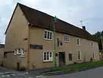 Bear House |
| Bluegates Farmhouse | Ashwell End, Ashwell, North Hertfordshire | Farmhouse | Mid 16th century | 9 June 1952 | TL2561440588 52°02′58″N 0°10′11″W |
1174817 | 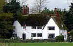 Bluegates Farmhouse |
| Ducklake | Ashwell, North Hertfordshire | House | c. 1600 | 9 June 1952 | TL2692639911 52°02′35″N 0°09′03″W |
1102721 | .jpg.webp) Ducklake |
| Forresters Cottage | Ashwell, North Hertfordshire | House | Late C15/Early 15th century | 27 May 1968 | TL2688039714 52°02′29″N 0°09′05″W |
1174915 | 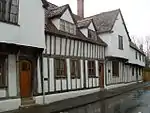 Forresters Cottage |
| Jessamine House | Ashwell, North Hertfordshire | House | c. 1700 | 27 May 1968 | TL2695739708 52°02′28″N 0°09′01″W |
1102750 |  |
| Rose and Crown Public House | Ashwell, North Hertfordshire | Cross Passage House | Late C15/Early 16th century | 9 June 1952 | TL2668439620 52°02′26″N 0°09′16″W |
1102708 |  Rose and Crown Public House |
| Town House (Ashwell Museum) | Ashwell, North Hertfordshire | House | c. 1500 | 19 November 1984 | TL2668739681 52°02′28″N 0°09′16″W |
1102724 | 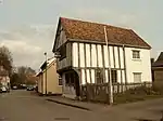 Town House (Ashwell Museum) |
| 57 and 59 High Street | Ashwell, North Hertfordshire | House | c. 1500 | 27 May 1968 | TL2673539644 52°02′27″N 0°09′13″W |
1347311 | .jpg.webp) 57 and 59 High Street |
| Butterfield House | Baldock | Rectory | 1870-73 | 15 August 1974 | TL2437733859 51°59′21″N 0°11′24″W |
1102078 | 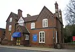 Butterfield House |
| Cokenach House including the Wing | Cokenach, Barkway, North Hertfordshire | Country House | c. 1570 | 27 May 1968 | TL3956236146 52°00′22″N 0°01′55″E |
1102628 | |
| The Gables | Barkway, North Hertfordshire | House | 17th century | 27 May 1968 | TL3845035531 52°00′03″N 0°00′55″E |
1102596 | |
| 2 High Street | Barkway, North Hertfordshire | House | Late 16th century | 24 July 1973 | TL3846635930 52°00′16″N 0°00′57″E |
1102599 | |
| 93/95 and 97 High Street | Barkway, North Hertfordshire | House | c. 1600 | 27 May 1968 | TL3838435301 51°59′56″N 0°00′52″E |
1174330 | 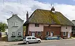 93/95 and 97 High Street |
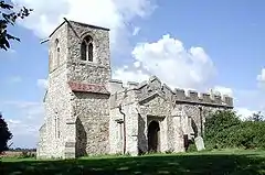
| Church of St Margaret of Antioch | Barley, Hertfordshire | Parish Church | 12th century | 27 May 1968 | TL4016638418 52°01′35″N 0°02′30″E |
1102577 | 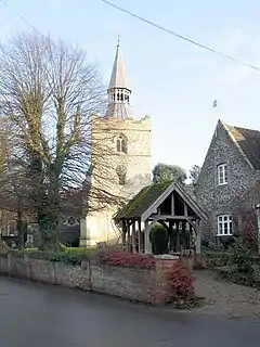 Church of St Margaret of Antioch |
| Hill House | Barley, North Hertfordshire | House | 1907 | 3 June 1987 | TL3992339021 52°01′55″N 0°02′18″E |
1102568 | |
| The Town House | Barley, North Hertfordshire | Church House | Early 16th century | 9 June 1952 | TL4013438441 52°01′36″N 0°02′28″E |
1347403 | 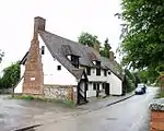 The Town House |
| Church of St Margaret of Antioch | Bygrave, North Hertfordshire | Parish Church | 12th century | 27 May 1968 | TL2660336134 52°00′33″N 0°09′25″W |
1175479 | 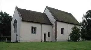 Church of St Margaret of Antioch |
| Church of St Mary Magdalene | Caldecote, Hertfordshire | Church | C14-15 | 27 May 1968 | TL2365438429 52°01′50″N 0°11′56″W |
1347341 | |
| Church of St Mary | Clothall, North Hertfordshire | Parish Church | 12th century | 27 May 1968 | TL2709832025 51°58′20″N 0°09′04″W |
1175746 | 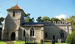 Church of St Mary |
| Parish Church of St Giles | Codicote, North Hertfordshire | Parish Church | 12th century | 27 May 1968 | TL2185218730 51°51′14″N 0°13′56″W |
1102834 | 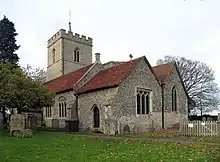 Parish Church of St Giles |
| The Bury | Codicote, North Hertfordshire | House | Soon after 1659 | 9 June 1952 | TL2188018541 51°51′08″N 0°13′55″W |
1347253 | |
| Ruins of Church of St Etheldrada | Graveley, Hertfordshire | Church ruin | 13th century or early 14th century | 9 June 1952 | TL2473227932 51°56′09″N 0°11′13″W |
1102564 | .jpg.webp) Ruins of Church of St Etheldrada |
| The Grange | Graveley, North Hertfordshire | House | Mid 18th century | 27 May 1968 | TL2308627895 51°56′09″N 0°12′40″W |
1175053 | 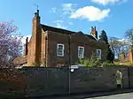 The Grange |
| Church of St Faith | Hexton, North Hertfordshire | Parish Church | Mid 13th century | 27 May 1968 | TL1038430358 51°57′39″N 0°23′42″W |
1347066 | 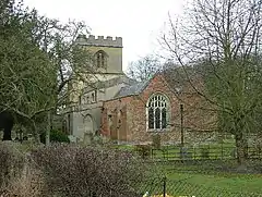 Church of St Faith |
| Church of St Nicholas | Hinxworth, North Hertfordshire | Parish Church | 14th century | 27 May 1968 | TL2373440347 52°02′52″N 0°11′50″W |
1347342 | 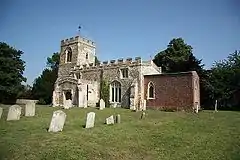 Church of St Nicholas |
| Hinxworth Place | Hinxworth, North Hertfordshire | House | 1980 | 19 November 1984 | TL2388339597 52°02′27″N 0°11′43″W |
1347346 | |
| Old Ramerick Manor | Ickleford, North Hertfordshire | Farmhouse | 1625 | 9 June 1952 | TL1717535009 52°00′04″N 0°17′40″W |
1174339 | |
| Church of St Faith | Kelshall, North Hertfordshire | Parish Church | Early 15th century | 27 May 1968 | TL3286536216 52°00′31″N 0°03′56″W |
1102650 |  Church of St Faith |
| The Old Homestead | Breachwood Green, King's Walden, North Hertfordshire | House | Early 17th century | 21 May 1979 | TL1501221910 51°53′02″N 0°19′49″W |
1176170 | |
| Church of St Martin | Knebworth, North Hertfordshire | Parish Church | 1914 | 27 May 1968 | TL2529320095 51°51′55″N 0°10′54″W |
1174371 | |
| Homewood | Knebworth, North Hertfordshire | House | 1900 | 2 May 1973 | TL2386519842 51°51′48″N 0°12′09″W |
1102736 | |
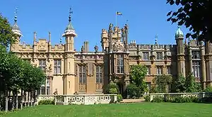
| Knebworth House | Old Knebworth, Knebworth, North Hertfordshire | Country House | 1492 | 9 June 1952 | TL2299720868 51°52′22″N 0°12′53″W |
1102767 | |
| Dyes Farmhouse | Langley, Hertfordshire | Farmhouse | Early 17th century | 8 February 1988 | TL2178123258 51°53′40″N 0°13′54″W |
1176520 | |
| Arunside | Letchworth Garden City, North Hertfordshire | House | 1904-5 | 7 September 1979 | TL2165431435 51°58′05″N 0°13′50″W |
1101993 | |
| Church of All Saints | Willian, Letchworth Garden City, North Hertfordshire | Parish Church | 12th century | 27 May 1954 | TL2246330657 51°57′39″N 0°13′09″W |
1174914 | 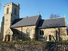 Church of All Saints |
| Letchworth Hall Hotel | Letchworth Garden City, North Hertfordshire | House | Early 17th century | 27 May 1954 | TL2173830819 51°57′45″N 0°13′46″W |
1174314 | 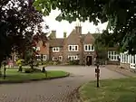 Letchworth Hall Hotel |
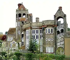
| North Hertfordshire Masonic Centre (the Cloisters) | Letchworth Garden City, North Hertfordshire | Fountain | 1906-7 | 7 September 1979 | TL2204331427 51°58′05″N 0°13′30″W |
1102019 | |
| Puncharden Hall | Willian, Letchworth Garden City, North Hertfordshire | House | Mid 18th century | 27 May 1954 | TL2241930736 51°57′42″N 0°13′11″W |
1295498 | |
| Tanglewood | Letchworth Garden City, North Hertfordshire | Timber Framed House | 1907 | 7 September 1979 | TL2128931592 51°58′10″N 0°14′09″W |
1295596 | |
| The Old Vicarage | Willian, Letchworth Garden City, North Hertfordshire | House | Modern | 27 May 1954 | TL2247630712 51°57′41″N 0°13′08″W |
1295503 | |
| The Spirella Company of Great Britain Ltd Building | Letchworth Garden City, North Hertfordshire | Factory | 1912 | 7 September 1979 | TL2149632793 51°58′49″N 0°13′57″W |
1347670 | 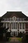 The Spirella Company of Great Britain Ltd Building |
| 296 Norton Way South | Letchworth Garden City, North Hertfordshire | Drawing Office | 1906-7 | 7 September 1979 | TL2212632389 51°58′36″N 0°13′24″W |
1102002 | |
| 102 Wilbury Road | Letchworth Garden City, North Hertfordshire | House | 1908 | 14 January 1977 | TL2130533674 51°59′18″N 0°14′06″W |
1102820 | |
| 158 Wilbury Road | Letchworth Garden City, North Hertfordshire | House | 1905 | 7 September 1979 | TL2187333701 51°59′18″N 0°13′36″W |
1174901 | |
| Church of St Peter | Lilley, Hertfordshire | Parish Church | 1870-72 | 27 May 1968 | TL1183226370 51°55′29″N 0°22′30″W |
1174639 | 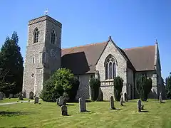 Church of St Peter |
| Church of St Vincent | Newnham, Hertfordshire | Parish Church | 12th century | 27 May 1968 | TL2433437637 52°01′24″N 0°11′22″W |
1347335 | 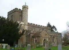 Church of St Vincent |
| Court House | Great Offley, Offley, North Hertfordshire | House | Early 17th century | 9 June 1952 | TL1434427014 51°55′48″N 0°20′18″W |
1347082 | |
| Little Offley | Little Offley, Offley, North Hertfordshire | Country House | Late 16th century | 9 June 1952 | TL1296228502 51°56′37″N 0°21′29″W |
1175061 | .jpg.webp) Little Offley |
| Farm Building at Entrance to Yard at Hammond's Farm | Pirton, Hertfordshire | Farm Building | 16th century or earlier | 24 October 1988 | TL1442132296 51°58′38″N 0°20′08″W |
1295388 | |
| Pirton Grange | Apsley End, Pirton, North Hertfordshire | House | 16th century | 9 June 1952 | TL1226832932 51°59′01″N 0°22′00″W |
1175572 | |
| Gatehouse at Pirton Grange | Apsley End, Pirton, North Hertfordshire | Bridge | 16th century or early 17th century | 27 May 1968 | TL1228532944 51°59′01″N 0°21′59″W |
1175594 | |
| Hammond's Farmhouse | Pirton, North Hertfordshire | Farmhouse | Early 16th century | 9 June 1952 | TL1444332288 51°58′38″N 0°20′07″W |
1175235 | |
| The Rectory Farmhouse | Pirton, North Hertfordshire | Farmhouse | Early 17th century | 9 June 1952 | TL1414831935 51°58′27″N 0°20′23″W |
1103158 | |
| Three Gables | Pirton, North Hertfordshire | House | 18th century | 24 October 1988 | TL1457831498 51°58′13″N 0°20′01″W |
1103185 | |
| West Barn at Rectory Farm | Pirton, North Hertfordshire | Threshing Barn | 15th century or early 16th century | 27 May 1968 | TL1410731886 51°58′25″N 0°20′25″W |
1175545 | |
| Princess Helena College, Temple Dinsley, with Terraces, Steps, Walls, Railings, Gates, Pergolas, and Garden Buildings | Preston, North Hertfordshire | House | 17th century | 9 June 1952 | TL1821324826 51°54′34″N 0°16′58″W |
1307766 | |
| Tudor House | Preston, North Hertfordshire | House | Mid 17th century | 27 May 1968 | TL1905724739 51°54′31″N 0°16′14″W |
1102430 | |
| Church of All Saints | Radwell, Hertfordshire | Parish Church | Medieval | 27 May 1968 | TL2323535856 52°00′27″N 0°12′22″W |
1102676 | 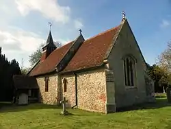 Church of All Saints |
| Royston Manor House | Royston, North Hertfordshire | House | Early 18th century | 14 June 1964 | TL3566940727 52°02′54″N 0°01′23″W |
1102011 | 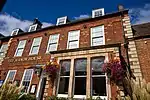 Royston Manor House |
| 4 Baldock Street | Royston, North Hertfordshire | House | Early 19th century | 11 June 1976 | TL3554040692 52°02′53″N 0°01′30″W |
1102056 | |
| 59 and 61 High Street | Royston, North Hertfordshire | House | Late 15th century or early 16th century | 14 June 1964 | TL3565540478 52°02′46″N 0°01′24″W |
1174560 | |
| 63 and 65 High Street | Royston, North Hertfordshire | House | Late 15th century or early 16th century | 14 June 1964 | TL3566140464 52°02′46″N 0°01′24″W |
1102071 | |
| 9 Kneesworth Street | Royston, North Hertfordshire | House | 15th century | 11 June 1976 | TL3558940774 52°02′56″N 0°01′27″W |
1102038 | 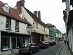 9 Kneesworth Street |
| 11 Kneesworth Street | Royston, North Hertfordshire | Palace Guardroom | 15th century | 11 June 1976 | TL3558640782 52°02′56″N 0°01′27″W |
1347678 | 11 Kneesworth Street |
| 17–21 Kneesworth Street | Royston, North Hertfordshire | Royal Palace | Modern | 14 June 1964 | TL3557340810 52°02′57″N 0°01′28″W |
1102039 | |
| Church of St Mary | Rushden, Hertfordshire | Parish Church | Mid 14th century | 27 May 1968 | TL3054131763 51°58′08″N 0°06′04″W |
1175887 | 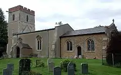 Church of St Mary |
| Julians | Rushden, North Hertfordshire | Country House | c. 1605 | 9 June 1952 | TL3079232548 51°58′34″N 0°05′50″W |
1347370 | 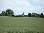 Julians |
| Barn about 35m South East of Sandon Bury | Sandon, Hertfordshire | Barn | Late 17th century | 27 May 1968 | TL3228934462 51°59′34″N 0°04′29″W |
1102609 | |
| Danyells | Sandon, North Hertfordshire | Farmhouse | c. 1700 | 27 May 1968 | TL3238534210 51°59′26″N 0°04′24″W |
1102610 | |
| Sandon Bury | Sandon, North Hertfordshire | Farmhouse | 15th century | 9 June 1952 | TL3224934486 51°59′35″N 0°04′31″W |
1102608 | |
| Avenue Farm House | St Ippolyts, North Hertfordshire | Farmhouse | Late Medieval | 27 May 1968 | TL1870427029 51°55′45″N 0°16′30″W |
1102505 | |
| Barn at Maydencroft Manor | Gosmore, St Ippolyts, North Hertfordshire | Barn | c. 1700 | 27 May 1968 | TL1814027381 51°55′57″N 0°16′59″W |
1295380 | |
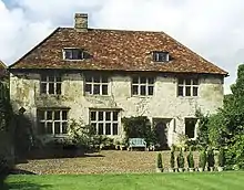
| Maydencroft Manor | Gosmore, St Ippolyts, North Hertfordshire | Farmhouse | Early 17th century | 9 June 1952 | TL1818927421 51°55′58″N 0°16′57″W |
1347391 |  Maydencroft Manor |
| Statue of Cain and Abel at the Bury at West End of Alley running West and North Front at Grid Reference Tl 1861 2177 | St Paul's Walden, North Hertfordshire | Statue | 18th century | 27 May 1968 | TL1861021770 51°52′55″N 0°16′41″W |
1347063 | |
| Statue of Charity at the Bury at Head of East Drive at Grid Reference Tl 1875 2162 | St Paul's Walden, North Hertfordshire | Statue | c. 1778 | 27 May 1968 | TL1875021620 51°52′50″N 0°16′34″W |
1177074 | |
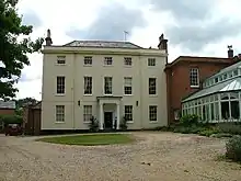
| The Bury | St Paul's Walden, North Hertfordshire | Country House | Early 18th century | 9 June 1952 | TL1876021689 51°52′52″N 0°16′34″W |
1307601 | |
| The Old Rectory | Therfield, North Hertfordshire | Rectory | Late 15th century | 9 June 1952 | TL3354536984 52°00′55″N 0°03′20″W |
1102613 | |
| Church of St Mary | Wallington, Hertfordshire | Parish Church | 14th century | 27 May 1968 | TL2923633546 51°59′07″N 0°07′10″W |
1347337 | 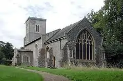 Church of St Mary |
| Irongate Farmhouse | Halls Green, Weston, North Hertfordshire | Farmhouse | Late 16th century or early 17th century | 28 May 1987 | TL2745628682 51°56′31″N 0°08′50″W |
1347439 | |
| Church of St Mary the Virgin | Little Wymondley, Wymondley, North Hertfordshire | Parish Church | Early 12th century | 27 May 1968 | TL2169227244 51°55′49″N 0°13′53″W |
1347444 | 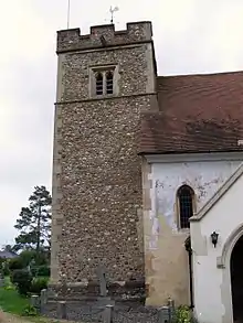 Church of St Mary the Virgin |
| Delamere House and Barn attached on West | Great Wymondley, Wymondley, North Hertfordshire | House | Mid 17th century | 9 May 1952 | TL2131728368 51°56′26″N 0°14′12″W |
1175691 | .jpg.webp) Delamere House and Barn attached on West |
| Redcoats Farmhouse Hotel | Little Wymondley, Wymondley, North Hertfordshire | Farmhouse | Late 17th century | 27 May 1968 | TL2075926591 51°55′29″N 0°14′43″W |
1102462 | |
| The Manor House | Great Wymondley, Wymondley, North Hertfordshire | Farmhouse | 15th century | 27 May 1968 | TL2134828700 51°56′37″N 0°14′10″W |
1347429 | |
| Tithe Barn at the Priory and attached Outbuildings | Little Wymondley, Wymondley, North Hertfordshire | Moat | 15th century or earlier | 27 May 1968 | TL2188027928 51°56′11″N 0°13′43″W |
1175825 | |
| Wymondley Hall | Little Wymondley, Wymondley, North Hertfordshire | Farmhouse | Late 16th century | 27 May 1968 | TL2158227594 51°56′01″N 0°13′59″W |
1102501 | |
| Wymondley House | Little Wymondley, Wymondley, North Hertfordshire | House | c. 1880 | 27 May 1968 | TL2115527424 51°55′56″N 0°14′21″W |
1175971 | |
| Biggin Almshouses | Hitchin, North Hertfordshire | Colonnade | Early 17th century | 13 April 1951 | TL1855129001 51°56′49″N 0°16′36″W |
1102181 | |
| Church of the Holy Saviour | Hitchin, North Hertfordshire | Church | 1875-1899 | 17 June 1974 | TL1907129637 51°57′09″N 0°16′08″W |
1102182 | |
| Halford House | Baldock, North Hertfordshire | House | 18th century | 8 November 1949 | TL2451433870 51°59′22″N 0°11′17″W |
1102099 | |
| Manor House | Baldock, North Hertfordshire | House | 18th century | 8 November 1949 | TL2457833769 51°59′18″N 0°11′14″W |
1102102 | |
| Manor House | Baldock, North Hertfordshire | House | 1728 | 8 November 1949 | TL2448233821 51°59′20″N 0°11′19″W |
1102108 | |
| Manor House Galleries | Hitchin, North Hertfordshire | HouseBritish Schools Museum | c. 1700 | 13 April 1951 | TL1851829417 51°57′02″N 0°16′37″W |
1347575 | |
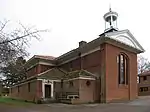
| North Eastern Block of Buildings at the British Schools Museum | Hitchin, North Hertfordshire | British and Foreign Society School | 1810 | 6 June 1975 | TL1865128860 51°56′44″N 0°16′31″W |
1224711 | 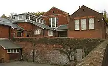 North Eastern Block of Buildings at the British Schools Museum |
| The Cottage | Baldock | Timber Framed House | 16th century or earlier | 15 August 1974 | TL2437233960 51°59′25″N 0°11′24″W |
1102134 | |
| The Sun Hotel | Hitchin | Assembly Rooms | Georgian | 13 April 1951 | TL1841928977 51°56′48″N 0°16′43″W |
1102139 | 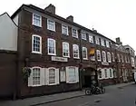 The Sun Hotel |
| Western House | 35 Tilehouse St, Hitchin | House | Earlier | 13 April 1951 | TL1817329030 51°56′50″N 0°16′55″W |
1347585 | |
| 13 White Horse Street | Baldock | Building | Earlier | 8 November 1949 | TL2447933974 51°59′25″N 0°11′19″W |
1102085 | |
| 105 and 106 Bancroft | Hitchin | House | 15th century | 13 April 1951 | TL1853729377 51°57′01″N 0°16′36″W |
1102225 | |
| 81 and 82 Tilehouse Street | Hitchin | Guildhall | 15th century | 13 April 1951 | TL1822829003 51°56′49″N 0°16′53″W |
1102122 | |
| 29 Bucklersbury | Hitchin | Jettied House | 16th century | 13 April 1951 | TL1834728963 51°56′48″N 0°16′46″W |
1102199 | |
| 33 and 34 Bucklersbury | Hitchin | Building | 15th century or 16th century | 13 April 1951 | TL1833428996 51°56′49″N 0°16′47″W |
1296286 | |
| 3 and 5 Church Street | Baldock | Building | 18th century | 8 November 1949 | TL2436733977 51°59′25″N 0°11′25″W |
1102135 | |
| 8–12 Market Place | Hitchin | Shop | Recent | 13 April 1951 | TL1843329081 51°56′51″N 0°16′42″W |
1102174 | |
| 23 and 23a High Street | Baldock | House | 18th century | 8 November 1949 | TL2458633757 51°59′18″N 0°11′13″W |
1347633 | |
| 31 and 32 Bridge Street | Hitchin | Jettied House | C15-16 | 13 April 1951 | TL1845428847 51°56′44″N 0°16′41″W |
1102191 | 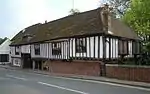 31 and 32 Bridge Street |
_(14783742633).jpg.webp)

Notes
- The date given is the date used by Historic England as significant for the initial building or that of an important part in the structure's description.
- Sometimes known as OSGB36, the grid reference is based on the British national grid reference system used by the Ordnance Survey.
- The "List Entry Number" is a unique number assigned to each listed building and scheduled monument by Historic England.
External links
![]() Media related to Grade II* listed buildings in Hertfordshire at Wikimedia Commons
Media related to Grade II* listed buildings in Hertfordshire at Wikimedia Commons
This article is issued from Wikipedia. The text is licensed under Creative Commons - Attribution - Sharealike. Additional terms may apply for the media files.