National Register of Historic Places listings in Neosho County, Kansas
This is a list of the National Register of Historic Places listings in Neosho County, Kansas. It is intended to be a complete list of the properties and districts on the National Register of Historic Places in Neosho County, Kansas, United States. The locations of National Register properties and districts for which the latitude and longitude coordinates are included below, may be seen in an online map.
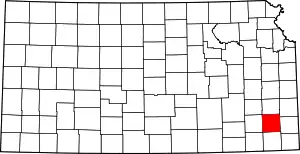
Location of Neosho County in Kansas
There are 8 properties and districts listed on the National Register in the county.
- This National Park Service list is complete through NPS recent listings posted February 5, 2021.[1]
Current listings
| [2] | Name on the Register[3] | Image | Date listed[4] | Location | City or town | Description |
|---|---|---|---|---|---|---|
| 1 | Austin Bridge | September 15, 1977 (#77000592) |
Western side of Santa Fe St. south of 21st. St. over Little Turkey Creek 37°39′25″N 95°27′11″W |
Chanute | Moved from original location to Santa Fe Park, approved by Register without delisting. | |
| 2 | Maxwell's Slough Bridge | July 2, 1985 (#85001429) |
Off K-57 0.5 miles west and 1 mile south of St. Paul 37°30′18″N 95°10′49″W |
St. Paul | ||
| 3 | Murray High School | 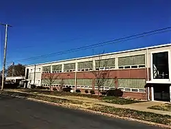 Murray High School |
August 23, 2011 (#11000580) |
400 W. 3rd St. 37°40′43″N 95°27′33″W |
Chanute | |
| 4 | Oak Grove School, District 20 | June 23, 2016 (#16000405) |
20505 20th Rd. 37°23′55″N 95°10′12″W |
St. Paul | ||
| 5 | Osage Mission Infirmary | September 6, 2005 (#05000976) |
325 Main St. 37°31′04″N 95°10′18″W |
St. Paul | ||
| 6 | State Street Bridge | July 2, 1985 (#85001441) |
State St. over Neosho River tributary 37°34′21″N 95°14′25″W |
Erie | ||
| 7 | Tioga Inn | 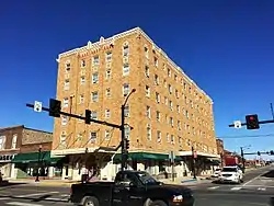 Tioga Inn |
February 23, 1990 (#90000150) |
12 E. Main St. 37°41′00″N 95°27′14″W |
Chanute | |
| 8 | James and Ella Truitt House | 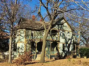 James and Ella Truitt House |
April 2, 2014 (#14000117) |
305 N. Steuben Ave. 37°41′05″N 95°27′25″W |
Chanute |
See also
References
| Wikimedia Commons has media related to National Register of Historic Places in Neosho County, Kansas. |
- "National Register of Historic Places: Weekly List Actions". National Park Service, United States Department of the Interior. Retrieved on February 5, 2021.
- Numbers represent an alphabetical ordering by significant words. Various colorings, defined here, differentiate National Historic Landmarks and historic districts from other NRHP buildings, structures, sites or objects.
- "National Register Information System". National Register of Historic Places. National Park Service. July 9, 2010.
- The eight-digit number below each date is the number assigned to each location in the National Register Information System database, which can be viewed by clicking the number.

| Topics | |
|---|---|
| Lists by state |
|
| Lists by insular areas | |
| Lists by associated state | |
| Other areas | |
| Related | |
| |
Municipalities and communities of Neosho County, Kansas, United States | ||
|---|---|---|
| Cities | Map of Kansas highlighting Neosho County | |
| Unincorporated communities | ||
| Civil townships | ||
| ||
This article is issued from Wikipedia. The text is licensed under Creative Commons - Attribution - Sharealike. Additional terms may apply for the media files.