Columbus Near East Side District
The Columbus Near East Side District is a historic district in the Near East Side of Columbus, Ohio. The site was listed on the National Register of Historic Places in 1978. A portion of the district, the Bryden Road District, was added to the Columbus Register of Historic Properties in 1990.[1][2][3] An addition, the Columbus Near East Side Historic District-Parsons Avenue, was added to the register in 1983.
Columbus Near East Side District | |
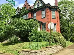 Contributing building | |
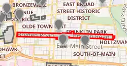
Map of the Bryden Road District among other historic sites and districts | |
| Location | Columbus, Ohio |
|---|---|
| Coordinates | 39.963119°N 82.966207°W |
| NRHP reference No. | 78002063[1] (original) 83004287 (increase) |
| CRHP No. | CR-44 |
| Significant dates | |
| Added to NRHP | May 19, 1978 |
| Boundary increase | December 9, 1983 |
| Designated CRHP | March 20, 1990 |
Columbus Public Health, Franklin Park, and the Franklin Park Conservatory all lie within the National Register district.[2]
References
- "National Register Information System". National Register of Historic Places. National Park Service. March 13, 2009.
- "National Register of Historic Places Registration Form". National Park Service. Retrieved June 25, 2020.
- "National Register of Historic Places Registration Form - boundary addition". National Park Service. Retrieved June 25, 2020.
External links
 Media related to Columbus Near East Side District at Wikimedia Commons

This article is issued from Wikipedia. The text is licensed under Creative Commons - Attribution - Sharealike. Additional terms may apply for the media files.