National Register of Historic Places listings in Delaware County, Ohio
This is a list of the National Register of Historic Places listings in Delaware County, Ohio.
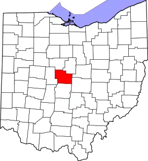
Location of Delaware County in Ohio
This is intended to be a complete list of the properties and districts on the National Register of Historic Places in Delaware County, Ohio, United States. The locations of National Register properties and districts for which the latitude and longitude coordinates are included below, may be seen in an online map.[1]
There are 58 properties and districts listed on the National Register in the county. Another property was once listed but has been removed.
- This National Park Service list is complete through NPS recent listings posted January 29, 2021.[2]
Current listings
| [3] | Name on the Register[4] | Image | Date listed[5] | Location | City or town | Description |
|---|---|---|---|---|---|---|
| 1 | Austin Hall |  Austin Hall |
March 18, 1985 (#85000631) |
Ohio Wesleyan University, W. Central Ave. and Elizabeth St. 40°18′06″N 83°04′37″W |
Delaware | |
| 2 | John Baker Tavern |  John Baker Tavern |
September 6, 2006 (#06000766) |
4151 State Route 203, in Radnor 40°22′46″N 83°08′58″W |
Radnor Township | |
| 3 | George Bieber House and Farm |  George Bieber House and Farm |
October 3, 1991 (#91001426) |
2010 Stratford Rd., south of Delaware 40°15′56″N 83°03′53″W |
Delaware Township | |
| 4 | Building at 101 North Franklin Street |  Building at 101 North Franklin Street |
November 25, 1980 (#80002990) |
101 N. Franklin St. 40°24′38″N 82°57′18″W |
Ashley | |
| 5 | Building at 223 West High Street |  Building at 223 West High Street |
November 25, 1980 (#80002991) |
223 W. High St. 40°24′33″N 82°57′41″W |
Ashley | |
| 6 | Building at 500 East High Street |  Building at 500 East High Street |
November 25, 1980 (#80002992) |
500 E. High St. 40°24′32″N 82°56′57″W |
Ashley | |
| 7 | Building at 505 East High Street |  Building at 505 East High Street |
November 25, 1980 (#80002993) |
505 E. High St. 40°24′32″N 82°56′54″W |
Ashley | |
| 8 | Center Inn | 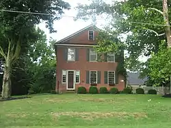 Center Inn |
January 11, 1983 (#83001956) |
Southeast of Sunbury on State Route 37 40°13′01″N 82°48′02″W |
Trenton Township | |
| 9 | Chambers Road Covered Bridge | 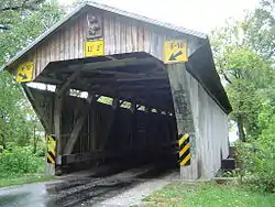 Chambers Road Covered Bridge |
November 21, 1974 (#74001465) |
1.5 mi (2.4 km) northeast of Olive Green 40°20′17″N 82°49′05″W |
Porter Township | |
| 10 | John Cook Farm |  John Cook Farm |
April 11, 1977 (#77001059) |
East of Harlem at Miller Paul Rd. and Gorsuch Rd. 40°09′05″N 82°49′26″W |
Harlem Township | |
| 11 | Samuel Cooper Farmhouse | 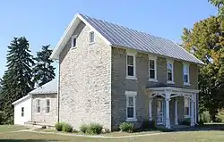 Samuel Cooper Farmhouse |
May 6, 1993 (#93000395) |
695 Lawrence Rd., south of Radnor 40°19′33″N 83°09′33″W |
Radnor Township | |
| 12 | Crist Tavern Annex-Millworkers Boarding House | 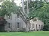 Crist Tavern Annex-Millworkers Boarding House |
March 25, 1994 (#94000277) |
2966 Olentangy River Rd., south of Delaware 40°15′20″N 83°03′51″W |
Delaware Township | |
| 13 | Marcus Curtiss Inn | 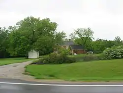 Marcus Curtiss Inn |
December 12, 1976 (#76001415) |
South of Galena at 3860 Sunbury Rd. 40°11′30″N 82°52′26″W |
Genoa Township | |
| 14 | Delaware County Courthouse |  Delaware County Courthouse |
May 22, 1973 (#73001429) |
N. Sandusky St. and Central Ave. 40°18′06″N 83°04′06″W |
Delaware | |
| 15 | Delaware County Jail and Sheriff's Residence | 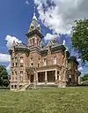 Delaware County Jail and Sheriff's Residence |
July 12, 1990 (#90001083) |
20 W. Central Ave. 40°18′06″N 83°04′09″W |
Delaware | |
| 16 | Delaware Post Office | December 30, 2019 (#100004824) |
60 South Sandusky St. 40°17′49″N 83°04′06″W |
Delaware | Now the Richard Ross Museum of Art | |
| 17 | Delaware Public Library | 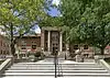 Delaware Public Library |
January 11, 1983 (#83001957) |
101 N. Sandusky St. 40°18′08″N 83°03′56″W |
Delaware | |
| 18 | John Detwiller Tavern and Farmstead |  John Detwiller Tavern and Farmstead |
April 16, 1993 (#93000294) |
2877 N. State Route 257, west of Radnor 40°22′00″N 83°11′19″W |
Thompson Township | |
| 19 | Edwards Gymnasium/Pfieffer Natatorium | 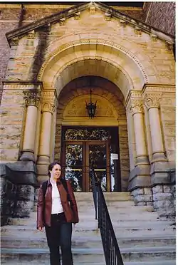 Edwards Gymnasium/Pfieffer Natatorium |
March 18, 1985 (#85000632) |
Ohio Wesleyan University Main Campus, S. Sandusky St. 40°17′41″N 83°04′03″W |
Delaware | |
| 20 | Elliott Hall, Sturges Library, and Merrick Hall | 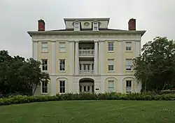 Elliott Hall, Sturges Library, and Merrick Hall |
April 23, 1973 (#73001430) |
Ohio Wesleyan University campus 40°17′46″N 83°03′58″W |
Delaware | |
| 21 | Felkner-Anderson House | 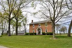 Felkner-Anderson House |
February 11, 1988 (#88000074) |
9716 Fontanelle Rd., northwest of Ostrander 40°17′02″N 83°14′20″W |
Scioto Township | |
| 22 | Gooding House and Tavern | 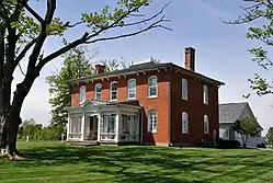 Gooding House and Tavern |
July 27, 2005 (#05000753) |
7669 Stagers Loop 40°10′53″N 83°01′29″W |
Orange Township | |
| 23 | Greenwood Farm |  Greenwood Farm |
April 17, 1979 (#79001825) |
North of Delaware off U.S. Route 42 40°18′42″N 83°03′41″W |
Delaware Township | |
| 24 | High House | 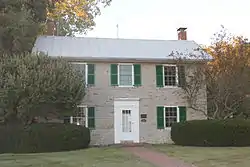 High House |
February 13, 1986 (#86000238) |
2360 Panhandle Rd., north of Delaware 40°19′51″N 83°03′44″W |
Troy Township | |
| 25 | Highbank Park Works | 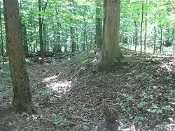 Highbank Park Works |
February 15, 1974 (#74001466) |
On a bluff above the eastern bank of the Olentangy River[6] 40°08′27″N 83°01′51″W |
Orange Township | |
| 26 | Highbanks Metropolitan Park Mounds I and II | 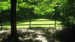 Highbanks Metropolitan Park Mounds I and II |
March 19, 1975 (#75001375) |
Eastern side of the Olentangy River, north of Worthington and east of Powell[7] 40°08′53″N 83°01′29″W |
Orange Township | |
| 27 | Historic Northwest District |  Historic Northwest District |
February 29, 1996 (#96000225) |
Roughly bounded by Pennsylvania Ave., N. Sandusky St., W. William St., Elizabeth St., W. Fountain St., and N. Franklin St. 40°18′30″N 83°04′07″W |
Delaware | |
| 28 | Diadatus Keeler House | 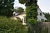 Diadatus Keeler House |
February 28, 1979 (#79001826) |
Southeast of Galena at 4567 Red Bank Rd. 40°10′45″N 82°51′50″W |
Genoa Township | |
| 29 | Samuel Lewis Farmhouse |  Samuel Lewis Farmhouse |
April 16, 1993 (#93000295) |
5979 Radnor Rd., west of Radnor 40°22′59″N 83°11′00″W |
Radnor Township | |
| 30 | Limestone Vale | 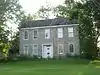 Limestone Vale |
October 2, 1978 (#78002055) |
3490 Olentangy River Rd., south of Delaware 40°14′52″N 83°03′38″W |
Liberty Township | |
| 31 | Forrest Meeker House and Farm |  Forrest Meeker House and Farm |
October 3, 1991 (#91001427) |
2690 Stratford Rd., south of Delaware 40°15′31″N 83°03′51″W |
Delaware Township | |
| 32 | Mill Worker House No. 1 | 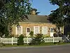 Mill Worker House No. 1 |
October 3, 1991 (#91001431) |
2665 Stratford Rd., south of Delaware 40°15′32″N 83°03′48″W |
Delaware Township | |
| 33 | Mill Worker House No. 3 | 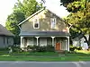 Mill Worker House No. 3 |
October 3, 1991 (#91001433) |
2505 Stratford Rd., south of Delaware 40°15′38″N 83°03′47″W |
Delaware Township | |
| 34 | Mill Worker House No. 4 |  Mill Worker House No. 4 |
October 3, 1991 (#91001434) |
2441 Stratford Rd., south of Delaware 40°15′39″N 83°03′47″W |
Delaware Township | |
| 35 | Mill Worker House No. 5 | 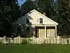 Mill Worker House No. 5 |
October 3, 1991 (#91001435) |
2441 Stratford Rd., south of Delaware 40°15′40″N 83°03′47″W |
Delaware Township | |
| 36 | Edward E. Neff House |  Edward E. Neff House |
January 28, 1988 (#87002546) |
123 N. Franklin St. 40°18′10″N 83°04′09″W |
Delaware | |
| 37 | O'Shaughnessy Dam and Bridge | O'Shaughnessy Dam and Bridge |
July 5, 1990 (#90000482) |
County Road 126 between State Routes 257 and 745, east of Shawnee Hills 40°09′14″N 83°07′34″W |
Concord and Liberty Townships | |
| 38 | Ohio Wesleyan University Fraternity Hill Historic District | August 29, 2019 (#100004312) |
4, 9, 10, 15, 19, 20, 23, 30, and 35 Williams Drive 40°17′48″N 83°04′36″W |
Delaware | ||
| 39 | Ohio Wesleyan University Student Observatory |  Ohio Wesleyan University Student Observatory |
March 18, 1985 (#85000633) |
Ohio Wesleyan University, W. William St. 40°17′55″N 83°04′35″W |
Delaware | |
| 40 | Norman Dewey Perry House | 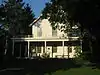 Norman Dewey Perry House |
October 3, 1991 (#91001429) |
2367 Stratford Rd., south of Delaware 40°15′46″N 83°03′45″W |
Delaware Township | |
| 41 | James Richey Farmhouse | 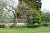 James Richey Farmhouse |
September 2, 1993 (#93000891) |
1395 S. State Route 257 40°17′59″N 83°09′55″W |
Scioto Township | |
| 42 | St. Mary's Church and Rectory | 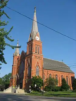 St. Mary's Church and Rectory |
May 23, 1980 (#80002994) |
82 E. William St. 40°17′54″N 83°03′58″W |
Delaware | |
| 43 | Sanborn Hall | 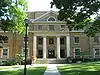 Sanborn Hall |
March 18, 1985 (#85000634) |
Ohio Wesleyan University, W. Campus 40°18′01″N 83°04′36″W |
Delaware | |
| 44 | Sandusky Street Historic District |  Sandusky Street Historic District |
December 17, 1982 (#82001373) |
44 S. to 92 N. Sandusky, 46 E. to 31 W. Winter, and 9 E. to 17 W. William 40°17′56″N 83°04′04″W |
Delaware | |
| 45 | Selby Field | 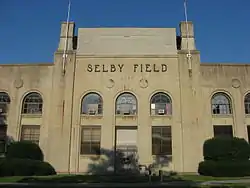 Selby Field |
March 18, 1985 (#85000635) |
Ohio Wesleyan University, Henry St. 40°17′48″N 83°03′49″W |
Delaware | |
| 46 | Samuel Sharp House | 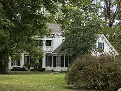 Samuel Sharp House |
July 29, 1982 (#82003563) |
7436 Horseshoe Rd., west of Ashley 40°24′00″N 83°02′07″W |
Marlboro Township | |
| 47 | Stephen Sharp House |  Stephen Sharp House |
September 30, 1982 (#82003564) |
8025 Africa Rd. 40°08′36″N 82°56′20″W |
Westerville | |
| 48 | Slocum Hall | 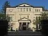 Slocum Hall |
March 18, 1985 (#85000636) |
Ohio Wesleyan University Main Campus, Sandusky St. 40°17′46″N 83°04′01″W |
Delaware | |
| 49 | Spruce Run Earthworks |  Spruce Run Earthworks |
July 16, 1973 (#73001431) |
Along Spruce Run south of Galena[8] 40°10′40″N 82°51′52″W |
Genoa Township | |
| 50 | Stratford Methodist Episcopal Church |  Stratford Methodist Episcopal Church |
October 3, 1991 (#91001436) |
Junction of U.S. Route 23 and State Route 315, south of Delaware 40°15′22″N 83°03′49″W |
Delaware Township | |
| 51 | Stuyvesant Hall |  Stuyvesant Hall |
March 18, 1985 (#85000637) |
Ohio Wesleyan University, W. William St. 40°17′54″N 83°04′33″W |
Delaware | |
| 52 | Sunbury Tavern |  Sunbury Tavern |
February 24, 1975 (#75001376) |
Northwestern corner of State Route 37 and Galena Rd. 40°14′31″N 82°51′36″W |
Sunbury | |
| 53 | Sunbury Town Hall |  Sunbury Town Hall |
February 20, 1975 (#75001377) |
Town Sq. 40°14′32″N 82°51′32″W |
Sunbury | |
| 54 | Ufferman Site | July 24, 1974 (#74001464) |
North of Delaware, near Delaware Lake[9] |
Troy Township | ||
| 55 | University Hall-Gray's Chapel |  University Hall-Gray's Chapel |
March 18, 1985 (#85000638) |
Ohio Wesleyan University Main Campus, Sandusky St. 40°17′47″N 83°04′01″W |
Delaware | |
| 56 | Henry Van Deman House |  Henry Van Deman House |
May 31, 1984 (#84003662) |
6 Darlington Rd. 40°18′31″N 83°04′30″W |
Delaware | |
| 57 | Warren Tavern Complex |  Warren Tavern Complex |
August 3, 1983 (#83001958) |
U.S. Route 36 west of Delaware 40°17′58″N 83°07′45″W |
Radnor Township | |
| 58 | West Orange Road-Thomas Bridge |  West Orange Road-Thomas Bridge |
June 26, 2002 (#02000701) |
Orange Rd., east of its junction with State Route 315, and northeast of Powell 40°10′31″N 83°02′44″W |
Liberty Township |
Former listing
| [3] | Name on the Register | Image | Date listed | Date removed | Location | City or town | Summary |
|---|---|---|---|---|---|---|---|
| 1 | Monnett Hall |  Monnett Hall |
June 23, 1975 (#75001374) | February 20, 1980 | Ohio Wesleyan University campus at Elizabeth and Winter Sts. 40°18′04″N 83°04′36″W |
Delaware |
See also
| Wikimedia Commons has media related to National Register of Historic Places in Delaware County, Ohio. |
References
- The latitude and longitude information provided in this table was derived originally from the National Register Information System, which has been found to be fairly accurate for about 99% of listings. Some locations in this table may have been corrected to current GPS standards.
- "National Register of Historic Places: Weekly List Actions". National Park Service, United States Department of the Interior. Retrieved on January 29, 2021.
- Numbers represent an alphabetical ordering by significant words. Various colorings, defined here, differentiate National Historic Landmarks and historic districts from other NRHP buildings, structures, sites or objects.
- "National Register Information System". National Register of Historic Places. National Park Service. April 24, 2008.
- The eight-digit number below each date is the number assigned to each location in the National Register Information System database, which can be viewed by clicking the number.
- Location derived from Squier, E.G., and E.H. Davis. Ancient Monuments of the Mississippi Valley. Washington: Smithsonian, 1848, page 36 and plate 14. The NRIS lists the site as "Address Restricted"
- Location derived from Highbanks Map, Metro Parks, 2009. Accessed 2012-11-23. The NRIS lists the site as "Address Restricted".
- Location derived from Mills, William C. Archeological Atlas of Ohio. Columbus: Ohio State Archeological and Historical Society, 1914, page 21 and plate 21. The NRIS lists the site as "Address Restricted".
- Location derived from this EPA document and pages 13-14 of this Delaware State Park webpage; the NRIS lists the site as "Address Restricted"

Municipalities and communities of Delaware County, Ohio, United States | ||
|---|---|---|
| Cities | Map of Ohio highlighting Delaware County | |
| Villages | ||
| Townships | ||
| CDPs | ||
| Unincorporated communities | ||
| Ghost towns | ||
| Footnotes | ‡This populated place also has portions in an adjacent county or counties | |
| ||
This article is issued from Wikipedia. The text is licensed under Creative Commons - Attribution - Sharealike. Additional terms may apply for the media files.