National Register of Historic Places listings in Highland County, Ohio
This is a list of the National Register of Historic Places listings in Highland County, Ohio.
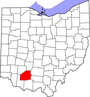
Location of Highland County in Ohio
This is intended to be a complete list of the properties and districts on the National Register of Historic Places in Highland County, Ohio, United States. The locations of National Register properties and districts for which the latitude and longitude coordinates are included below, may be seen in an online map.[1]
There are 27 properties and districts listed on the National Register in the county. Another property was once listed but has been removed.
- This National Park Service list is complete through NPS recent listings posted January 29, 2021.[2]
Current listings
| [3] | Name on the Register[4] | Image | Date listed[5] | Location | City or town | Description |
|---|---|---|---|---|---|---|
| 1 | Barretts Mill | 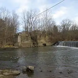 Barretts Mill |
December 26, 1972 (#72001024) |
County Road 1A and Rocky Fork Creek, southeast of Rainsboro; also on Factory Branch Creek 39°12′07″N 83°23′14″W |
Paint Township | Factory Branch Creek represents a boundary increase of July 24, 1979. This mill and covered bridge was destroyed by fire on October 14, 1980. |
| 2 | Bell Mansion | 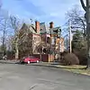 Bell Mansion |
November 25, 1980 (#80003099) |
225 Oak St. 39°12′05″N 83°37′17″W |
Hillsboro | |
| 3 | Bell's First Home | 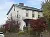 Bell's First Home |
November 25, 1980 (#80003096) |
222 Beech St. 39°12′15″N 83°36′53″W |
Hillsboro | |
| 4 | Bell's Opera House | 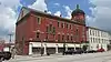 Bell's Opera House |
November 25, 1980 (#80003097) |
109-119 S. High St. 39°12′06″N 83°36′43″W |
Hillsboro | |
| 5 | C. S. Bell Foundry and Showroom | 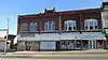 C. S. Bell Foundry and Showroom |
November 25, 1980 (#80003098) |
154-158 W. Main St. 39°12′10″N 83°36′49″W |
Hillsboro | |
| 6 | East Main Street Historic District | 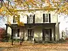 East Main Street Historic District |
June 1, 1982 (#82003594) |
E. Main and E. Walnut Sts. 39°12′04″N 83°36′30″W |
Hillsboro | |
| 7 | Eubanks-Tytus House |  Eubanks-Tytus House |
February 27, 1979 (#79001865) |
Southeast of Hillsboro on State Route 41 39°08′55″N 83°21′59″W |
Brushcreek Township | |
| 8 | Fort Hill State Park |  Fort Hill State Park |
November 10, 1970 (#70000500) |
Southeast of Hillsboro on State Route 41 39°06′38″N 83°24′10″W |
Brushcreek Township | |
| 9 | Greenfield Commercial Historic District | January 7, 2021 (#100005996) |
Roughly bounded by Jefferson, Washington, and Mirabeau Sts. 39°21′04″N 83°22′58″W |
Greenfield | ||
| 10 | Highland County Courthouse | 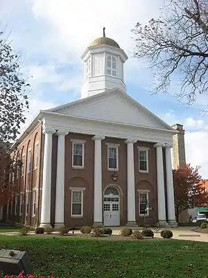 Highland County Courthouse |
August 24, 1978 (#78002087) |
Main and High Sts. 39°12′09″N 83°36′44″W |
Hillsboro | |
| 11 | Highland Pants factory | 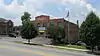 Highland Pants factory |
January 24, 2002 (#01001524) |
135 N. West St. 39°12′13″N 83°36′50″W |
Hillsboro | |
| 12 | Hillsboro Historic Business District | 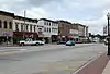 Hillsboro Historic Business District |
April 19, 1984 (#84003727) |
Roughly bounded by Beech, Walnut, East, and West Sts. 39°12′08″N 83°36′44″W |
Hillsboro | |
| 13 | Hirons-Brown House | 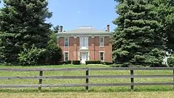 Hirons-Brown House |
December 12, 1976 (#76001455) |
Southwest of Buford on Buford-Bardwell Rd. 39°03′51″N 83°51′50″W |
Clay Township | |
| 14 | Robert D. Lilley House | 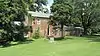 Robert D. Lilley House |
June 17, 1982 (#82003595) |
7915 State Route 124 39°11′59″N 83°35′43″W |
Hillsboro | |
| 15 | Samuel Lyle Log House | 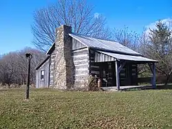 Samuel Lyle Log House |
July 28, 1995 (#95000939) |
7190 Pondlick Rd., northwest of Seaman 39°02′21″N 83°37′29″W |
Concord Township | |
| 16 | Lynchburg Covered Bridge | 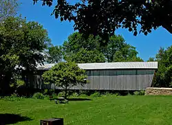 Lynchburg Covered Bridge |
March 16, 1976 (#76001456) |
East Fork of the Little Miami River 39°14′42″N 83°47′40″W |
Lynchburg | Extends into Clinton County |
| 17 | Morrow-Overman-Fairley House | 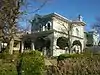 Morrow-Overman-Fairley House |
May 31, 1984 (#84003729) |
404 N. High St. 39°12′22″N 83°36′37″W |
Hillsboro | |
| 18 | Mother Thompson House | 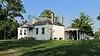 Mother Thompson House |
June 1, 1982 (#82003596) |
133 Willow St. 39°12′20″N 83°36′33″W |
Hillsboro | Due to extreme disrepair, the Mother Thompson House was demolished on May 19, 2017.[6] |
| 19 | New Market Township Community House | 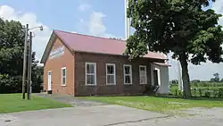 New Market Township Community House |
March 10, 2004 (#04000151) |
4641 U.S. Route 62, southwest of Hillsboro 39°08′15″N 83°40′06″W |
New Market Township | |
| 20 | Rocky Fork Park Group |  Rocky Fork Park Group |
June 18, 1973 (#73001478) |
Southern side of Rocky Fork Lake east of Fisherman's Wharf[7] 39°10′36″N 83°29′58″W |
Marshall Township | Location is for the West Mound, one of three mounds in the group[8] |
| 21 | Rocky Fork Park Site |  Rocky Fork Park Site |
June 18, 1973 (#73001479) |
South of Rocky Fork and west of Fisherman Wharf Rd.[9] 39°10′19″N 83°30′40″W |
Marshall Township | A pair of circular enclosures on a hillside[10] |
| 22 | Saint Mary's Episcopal Church and Parish House | 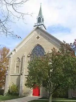 Saint Mary's Episcopal Church and Parish House |
September 8, 1988 (#88001421) |
232 N. High St. 39°12′16″N 83°36′38″W |
Hillsboro | |
| 23 | William Scott House | 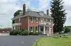 William Scott House |
November 5, 1987 (#87001981) |
338 W. Main St. 39°12′13″N 83°37′04″W |
Hillsboro | |
| 24 | Samuel Smith House and Tannery | 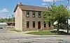 Samuel Smith House and Tannery |
July 5, 1978 (#78002086) |
103 Jefferson St. 39°21′09″N 83°22′45″W |
Greenfield | |
| 25 | Travellers' Rest Inn | 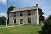 Travellers' Rest Inn |
May 15, 1979 (#79001864) |
Jefferson St. and McArthur Way 39°21′07″N 83°22′43″W |
Greenfield | |
| 26 | Trop Farm | 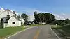 Trop Farm |
April 1, 1982 (#82003597) |
6250 Mad River Rd., west of Hillsboro 39°10′53″N 83°40′32″W |
New Market Township | |
| 27 | Workman Works |  Workman Works |
October 26, 1971 (#71000641) |
4206 Certier Rd.[11] 39°07′27″N 83°48′52″W |
Salem Township | Also known as Fort Salem. |
Former listing
| [3] | Name on the Register | Image | Date listed | Date removed | Location | City or town | Summary |
|---|---|---|---|---|---|---|---|
| 1 | Plum Run Mound | Unavailable (#72001592) | 1974 | Address Restricted |
Rainsboro |
See also
| Wikimedia Commons has media related to National Register of Historic Places in Highland County, Ohio. |
References
- The latitude and longitude information provided in this table was derived originally from the National Register Information System, which has been found to be fairly accurate for about 99% of listings. Some locations in this table may have been corrected to current GPS standards.
- "National Register of Historic Places: Weekly List Actions". National Park Service, United States Department of the Interior. Retrieved on January 29, 2021.
- Numbers represent an alphabetical ordering by significant words. Various colorings, defined here, differentiate National Historic Landmarks and historic districts from other NRHP buildings, structures, sites or objects.
- "National Register Information System". National Register of Historic Places. National Park Service. March 13, 2009.
- The eight-digit number below each date is the number assigned to each location in the National Register Information System database, which can be viewed by clicking the number.
- Gilliand, Jeff (May 12, 2017). "Mother Thompson House Coming Down". Civitas Media. Retrieved 3 August 2017.
- Case, D. Troy, and Christopher Carr. The Scioto Hopewell and Their Neighbors: Bioarchaeological Documentation and Cultural Understanding. New York: Springer, 2007, Appendix 7.1.
- Owen, Lorrie K., ed. Dictionary of Ohio Historic Places. Vol. 2. St. Clair Shores: Somerset, 1999, 770.
- Mills, William C. Archeological Atlas of Ohio. Columbus: Ohio State Archeological and Historical Society, 1914, page 36 and plate 36.
- Owen, Lorrie K., ed. Dictionary of Ohio Historic Places. Vol. 2. St. Clair Shores: Somerset, 1999, 770.
- Location derived from property owner's website Archived 2009-09-02 at the Wayback Machine; the NRIS lists the site as "Address Restricted"

Municipalities and communities of Highland County, Ohio, United States | ||
|---|---|---|
| City | Map of Ohio highlighting Highland County | |
| Villages | ||
| Townships | ||
| CDPs | ||
| Unincorporated communities | ||
| Footnotes | ‡This populated place also has portions in an adjacent county or counties | |
| ||
This article is issued from Wikipedia. The text is licensed under Creative Commons - Attribution - Sharealike. Additional terms may apply for the media files.