National Register of Historic Places listings in Dayton, Ohio
This is a list of the National Register of Historic Places listings in Dayton, Ohio.
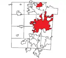
This is intended to be a complete list of the properties and districts on the National Register of Historic Places in Dayton, Ohio, United States. The locations of National Register properties and districts for which the latitude and longitude coordinates are included below, may be seen in an online map.[1]
There are 152 properties and districts listed on the National Register in Montgomery County, including 7 National Historic Landmarks. The city of Dayton is the location of 110 of these properties and districts, including 5 National Historic Landmarks; they are listed here, while the remaining properties and districts are listed separately. A single property, the Miami Valley Golf Course and Clubhouse, is split between Dayton and other parts of the county, and it thus appears on both lists. Another 2 properties in Dayton were once listed but have been removed.
- This National Park Service list is complete through NPS recent listings posted January 29, 2021.[2]
Current listings
| [3] | Name on the Register[4] | Image | Date listed[5] | Location | Description |
|---|---|---|---|---|---|
| 1 | Antioch Temple |  Antioch Temple |
January 14, 2013 (#12001182) |
107 E. 1st St. 39°45′47″N 84°11′26″W |
|
| 2 | Biltmore Hotel | 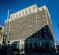 Biltmore Hotel |
February 3, 1982 (#82003616) |
210 N. Main St. 39°45′46″N 84°11′32″W |
|
| 3 | Bimm Fireproof Warehouse | 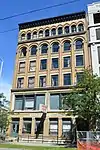 Bimm Fireproof Warehouse |
July 18, 2016 (#16000461) |
315 E. 1st St. 39°45′49″N 84°11′13″W |
|
| 4 | Marcus Bossler House |  Marcus Bossler House |
September 27, 1980 (#80003170) |
136 S. Dutoit St. 39°45′44″N 84°10′25″W |
|
| 5 | James Brooks House |  James Brooks House |
May 29, 1975 (#75001495) |
41 E. 1st St. 39°45′46″N 84°11′28″W |
|
| 6 | Samuel N. Brown House |  Samuel N. Brown House |
April 11, 1977 (#77001075) |
1633 Wayne Ave. 39°44′42″N 84°10′12″W |
|
| 7 | Jonah Bull House |  Jonah Bull House |
December 19, 2008 (#08001198) |
2233 Wayne Ave. 39°44′22″N 84°09′47″W |
|
| 8 | Central Avenue Historic District | 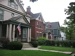 Central Avenue Historic District |
December 16, 1982 (#82001476) |
201-338 Central Ave. 39°46′02″N 84°12′27″W |
|
| 9 | Central Branch, National Home for Disabled Volunteer Soldiers | 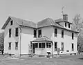 Central Branch, National Home for Disabled Volunteer Soldiers |
January 15, 2004 (#03001412) |
4100 W. 3rd St. 39°44′35″N 84°15′39″W |
National Historic Landmark designation October 16, 2012 |
| 10 | Commercial Building | 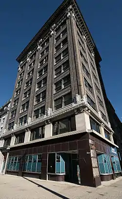 Commercial Building |
December 2, 1982 (#82001477) |
44 S. Ludlow St. 39°45′29″N 84°11′36″W |
|
| 11 | Conover Building | 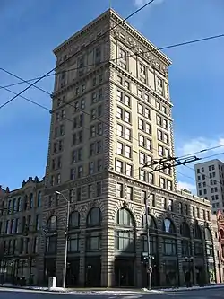 Conover Building |
October 14, 1975 (#75001497) |
4 S. Main St. 39°45′33″N 84°11′29″W |
|
| 12 | Dayton Arcade | 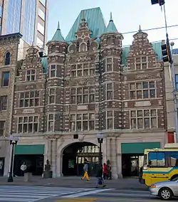 Dayton Arcade |
June 18, 1975 (#75001498) |
From Ludlow to Main St. between 3rd and 4th Sts. 39°45′30″N 84°11′33″W |
|
| 13 | Dayton Art Institute | 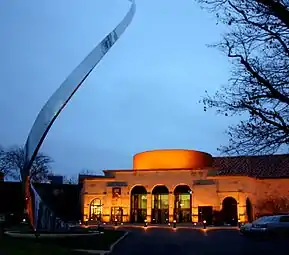 Dayton Art Institute |
November 19, 1974 (#74001579) |
Forest and Riverview Aves. 39°45′57″N 84°12′04″W |
|
| 14 | Dayton Aviation Heritage National Historical Park | 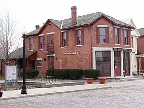 Dayton Aviation Heritage National Historical Park |
September 8, 1988 (#01000227) |
16 South Williams Street 39°45′21″N 84°12′42″W |
|
| 15 | Dayton Canoe Club |  Dayton Canoe Club |
July 2, 2008 (#08000591) |
1020 Riverside Dr. 39°46′32″N 84°11′48″W |
|
| 16 | Dayton Daily News Building | 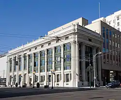 Dayton Daily News Building |
November 30, 1978 (#78002144) |
4th and Ludlow Sts. 39°45′28″N 84°11′37″W |
|
| 17 | Dayton Fire Department Station No. 16 |  Dayton Fire Department Station No. 16 |
May 23, 1980 (#80003171) |
31 S. Jersey St. 39°45′53″N 84°09′12″W |
|
| 18 | Dayton Fire Station No. 14 | 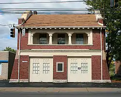 Dayton Fire Station No. 14 |
September 27, 1980 (#80003172) |
1422 N. Main St. 39°46′38″N 84°12′09″W |
|
| 19 | Dayton Motor Car Company Historic District |  Dayton Motor Car Company Historic District |
May 31, 1984 (#84003785) |
15, 101, 123-5 Bainbridge; 9-111 and 122-124 McDonough 39°45′34″N 84°10′50″W |
|
| 20 | Dayton Power and Light Building Group |  Dayton Power and Light Building Group |
April 12, 2006 (#06000273) |
601, 607-609, 613-645 E. 3rd St. 39°45′40″N 84°10′57″W |
|
| 21 | Dayton Stove and Cornice Works |  Dayton Stove and Cornice Works |
November 26, 1980 (#80003173) |
24-28 N. Patterson Boulevard 39°45′39″N 84°11′12″W |
Demolished |
| 22 | Dayton Terra-Cotta Historic District |  Dayton Terra-Cotta Historic District |
May 31, 1984 (#84003789) |
S. Ludlow and W. 5th Sts. 39°45′23″N 84°11′32″W |
|
| 23 | Dayton View Historic District | 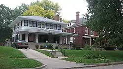 Dayton View Historic District |
July 19, 1984 (#84003787) |
Roughly bounded by Broadway, Harvard Boulevard, and Superior and Salem Aves. 39°46′04″N 84°12′59″W |
|
| 24 | Dayton Women's Club | 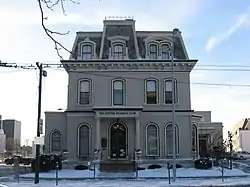 Dayton Women's Club |
February 24, 1975 (#75001499) |
225 N. Ludlow St. 39°45′46″N 84°11′42″W |
|
| 25 | Dayton Young Men's Christian Association Building | 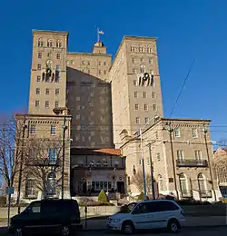 Dayton Young Men's Christian Association Building |
August 25, 1988 (#88001299) |
117 W. Monument Ave. 39°45′49″N 84°11′45″W |
|
| 26 | Deeds' Barn | 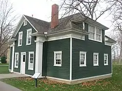 Deeds' Barn |
December 4, 1979 (#79001904) |
Carillon Historical Park 39°43′42″N 84°12′03″W |
Moved in 2009 from its previous location at 35 Moraine Circle in Kettering[6] |
| 27 | Deeds Carillon | 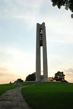 Deeds Carillon |
July 27, 2005 (#05000756) |
1000 Carillon Boulevard 39°43′51″N 84°11′51″W |
|
| 28 | Delco Building |  Delco Building |
July 14, 2016 (#16000462) |
329 E. 1st St. 39°45′49″N 84°11′11″W |
|
| 29 | Downtown Dayton Historic District | August 29, 2019 (#100004316) |
Roughly bounded by I 75, St. Clair St., west face of Patterson Blvd., Monument Ave., and Sixth St./Norfolk Southern Railroad line 39°45′39″N 84°11′32″W |
||
| 30 | Dunbar Historic District | 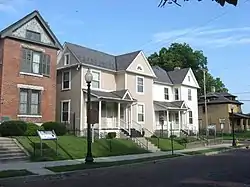 Dunbar Historic District |
June 30, 1980 (#80003174) |
N. Summit St. 39°45′23″N 84°13′08″W |
|
| 31 | Paul Laurence Dunbar House | 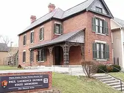 Paul Laurence Dunbar House |
October 15, 1966 (#66000619) |
219 N. Summit St. 39°45′20″N 84°13′08″W |
|
| 32 | Duncarrick | 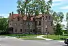 Duncarrick |
June 30, 1983 (#83002010) |
Webster and Keowee Sts. 39°46′44″N 84°11′03″W |
|
| 33 | Eagles Building | 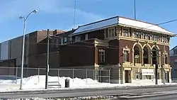 Eagles Building |
November 4, 1982 (#82001478) |
320 S. Main St. 39°45′17″N 84°11′24″W |
|
| 34 | East Second Street District |  East Second Street District |
March 7, 1979 (#79001898) |
3-27 E. 2nd St. 39°45′40″N 84°11′30″W |
Consisted of 6 buildings, all of which have been demolished |
| 35 | East Third Street Historic District |  East Third Street Historic District |
February 2, 2001 (#01000049) |
424-520 East 3rd St. (southern side only) 39°45′37″N 84°11′08″W |
|
| 36 | Engineers Club of Dayton | 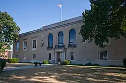 Engineers Club of Dayton |
October 17, 2007 (#07001091) |
110 E. Monument Ave. 39°45′49″N 84°11′27″W |
|
| 37 | Exposition Hall, Montgomery County Fairgrounds |  Exposition Hall, Montgomery County Fairgrounds |
December 10, 2003 (#03001287) |
Montgomery County Fairgrounds, 1043 S. Main St. 39°44′38″N 84°11′20″W |
|
| 38 | Fire Blocks Historic District |  Fire Blocks Historic District |
October 15, 1992 (#92001374) |
Roughly bounded by Jefferson, 4th, St. Clair, and 2nd Sts. 39°45′30″N 84°11′20″W |
|
| 39 | First Lutheran Church | 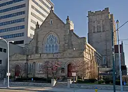 First Lutheran Church |
March 29, 1983 (#83002011) |
138 W. 1st St. 39°45′41″N 84°11′45″W |
|
| 40 | Philip E. Gilbert Houses |  Philip E. Gilbert Houses |
August 3, 1979 (#79001899) |
1012 Huffman Ave. and 18-30 Belpre Pl. 39°45′27″N 84°09′05″W |
|
| 41 | Oscar M. Gottschall House |  Oscar M. Gottschall House |
April 11, 1977 (#77001076) |
20 Livingston Ave. 39°45′27″N 84°08′54″W |
|
| 42 | Grafton-Rockwood Historic District |  Grafton-Rockwood Historic District |
March 22, 2010 (#10000084) |
Parts of Grafton, Homewood, Rockwood Ave, Oaks Ave, Old Orchard Ave. 39°46′24″N 84°12′23″W |
|
| 43 | Grant-Deneau Tower |  Grant-Deneau Tower |
February 23, 2016 (#16000044) |
40 W. 4th St. 39°45′27″N 84°11′34″W |
|
| 44 | Graphic Arts Building | 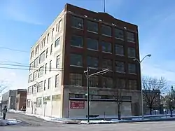 Graphic Arts Building |
November 12, 2009 (#09000911) |
221-223 S. Ludlow St. 39°45′21″N 84°11′35″W |
|
| 45 | Gummer House |  Gummer House |
February 17, 1978 (#78002145) |
1428 Huffman Ave. 39°45′26″N 84°08′35″W |
|
| 46 | Hanitch-Huffman House |  Hanitch-Huffman House |
March 29, 1982 (#82003617) |
139 W. Monument Ave. 39°45′47″N 84°11′46″W |
|
| 47 | Holy Cross Lithuanian Roman Catholic Church | 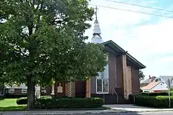 Holy Cross Lithuanian Roman Catholic Church |
November 5, 1991 (#91001582) |
1924 Leo St. 39°46′53″N 84°10′04″W |
|
| 48 | Huffman Historic District | 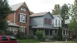 Huffman Historic District |
August 24, 1982 (#82003618) |
Roughly bounded by E. 3rd, Hamilton, Van Lear, and Beckel Sts. 39°45′41″N 84°09′59″W |
|
| 49 | Incinerator Site | 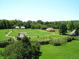 Incinerator Site |
April 1, 1975 (#75001500) |
2301 W. River Rd.[7] 39°42′48″N 84°13′56″W |
Also known as SunWatch Indian Village |
| 50 | Independent Order of Oddfellows, Dayton Lodge No. 273 |  Independent Order of Oddfellows, Dayton Lodge No. 273 |
October 25, 1984 (#84000109) |
8 LaBelle St. 39°45′30″N 84°10′23″W |
|
| 51 | Insco Apartments Building | 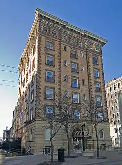 Insco Apartments Building |
February 18, 1994 (#93001390) |
255 N. Main St. 39°45′48″N 84°11′37″W |
|
| 52 | Jacob O. Joyce House |  Jacob O. Joyce House |
November 25, 1983 (#83004321) |
6 Josie St. 39°45′21″N 84°10′33″W |
|
| 53 | Julienne Girls Catholic High School |  Julienne Girls Catholic High School |
January 8, 2009 (#08001297) |
325 Homewood Ave. 39°46′34″N 84°12′17″W |
Demolished in 2012.[8] |
| 54 | Kelly Family Home |  Kelly Family Home |
June 30, 1975 (#75001501) |
657 S. Main St. 39°44′58″N 84°11′21″W |
|
| 55 | Lewis Kemp House |  Lewis Kemp House |
January 23, 1975 (#75001502) |
4800 Burkhardt Ave. 39°45′37″N 84°07′33″W |
|
| 56 | Kenilworth Avenue Historic District | 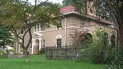 Kenilworth Avenue Historic District |
August 9, 2006 (#06000695) |
1131-1203 Salem Ave., 701-761 Kenilworth 39°46′33″N 84°12′58″W |
|
| 57 | Kossuth Colony Historic District | 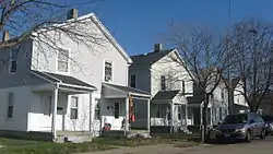 Kossuth Colony Historic District |
December 21, 1979 (#79001900) |
Baltimore St., Mack and Notre Dame Aves. 39°47′00″N 84°10′17″W |
|
| 58 | Benjamin F. Kuhns Building |  Benjamin F. Kuhns Building |
April 24, 1978 (#78002146) |
43 S. Main St. 39°45′29″N 84°11′31″W |
|
| 59 | Lafee Building |  Lafee Building |
November 25, 1980 (#80003175) |
22 E. 3rd St. 39°45′34″N 84°11′28″W |
|
| 60 | Lichliter Mound and Village Site |  Lichliter Mound and Village Site |
June 4, 1973 (#73001510) |
Fields on the northern side of an intermittent stream, 1 mile (1.6 km) above Wolf Creek and 6 miles (9.7 km) above the Great Miami River[9] 39°46′46″N 84°17′08″W |
|
| 61 | Linden Recreation and Community Center | 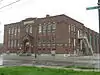 Linden Recreation and Community Center |
March 26, 2014 (#14000082) |
334 Norwood Ave. 39°45′09″N 84°12′26″W |
|
| 62 | Lindsey Building |  Lindsey Building |
March 14, 1985 (#85000564) |
25 S. Main St. 39°45′31″N 84°11′31″W |
|
| 63 | McCormick Manufacturing Company Building |  McCormick Manufacturing Company Building |
February 2, 2001 (#01000050) |
434-438 E. 1st St. 39°45′49″N 84°11′03″W |
|
| 64 | McPherson Town Historic District | 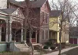 McPherson Town Historic District |
September 29, 1988 (#88001712) |
Roughly bounded by Main St., the Great Miami River, and Interstate 75 39°46′03″N 84°11′46″W |
|
| 65 | Memorial Hall | 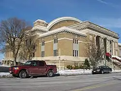 Memorial Hall |
July 14, 1988 (#88001062) |
125 E. 1st St. 39°45′51″N 84°11′23″W |
|
| 66 | Miami Valley Golf Course and Clubhouse |  Miami Valley Golf Course and Clubhouse |
June 30, 2015 (#15000372) |
3311 Salem Ave. 39°47′30″N 84°14′15″W |
Extends into Harrison Township, elsewhere in Montgomery County |
| 67 | Daniel Miller House |  Daniel Miller House |
May 29, 1975 (#75001504) |
3525 Dandridge Ave. 39°45′59″N 84°14′49″W |
|
| 68 | Montgomery County Courthouse | 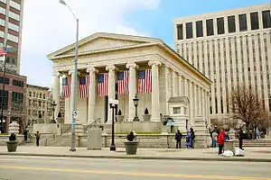 Montgomery County Courthouse |
January 26, 1970 (#70000510) |
Northwestern corner of 3rd and Main Sts. 39°45′33″N 84°11′33″W |
|
| 69 | Jacob H.W. Mumma House |  Jacob H.W. Mumma House |
May 29, 1980 (#80003176) |
2239 Kipling Dr. 39°47′24″N 84°14′37″W |
|
| 70 | Mutual Home & Savings Association Building | 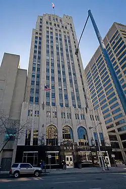 Mutual Home & Savings Association Building |
December 16, 1982 (#82001480) |
120 W. 2nd St. 39°45′37″N 84°11′43″W |
|
| 71 | Newcom House |  Newcom House |
July 21, 1980 (#80003177) |
Carillon Historical Park 39°43′42″N 84°12′02″W |
Moved in 2009 from its previous location at 35 Moraine Circle in Kettering[6] |
| 72 | Nicholas Ohmer House |  Nicholas Ohmer House |
October 16, 1974 (#74001580) |
1350 Creighton St. 39°44′26″N 84°09′14″W |
|
| 73 | Old Post Office And Federal Building | 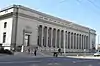 Old Post Office And Federal Building |
March 10, 1975 (#75001505) |
120 W. 3rd St. 39°45′30″N 84°11′41″W |
|
| 74 | Oregon Historic District |  Oregon Historic District |
March 27, 1975 (#75001506) |
Between Patterson Boulevard and Wayne Ave., north to Gates St. and south to U.S. Route 35 39°45′19″N 84°11′04″W |
|
| 75 | Isaac Pollack House | 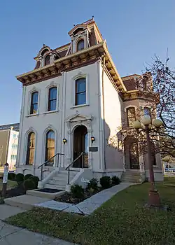 Isaac Pollack House |
December 16, 1974 (#74001581) |
208 W. Monument Ave.[10] 39°45′46″N 84°11′48″W |
|
| 76 | Rudolph Pretzinger House | 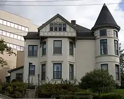 Rudolph Pretzinger House |
August 24, 1979 (#79001901) |
908 S. Main St 39°44′45″N 84°11′16″W |
|
| 77 | Red Oak-William C. Sherman House |  Red Oak-William C. Sherman House |
September 8, 2000 (#00001064) |
1231 Hook Estates Dr. 39°47′43″N 84°14′00″W |
|
| 78 | John R. Reynolds House |  John R. Reynolds House |
November 21, 1976 (#76001499) |
24 Klee St. 39°45′27″N 84°08′58″W |
|
| 79 | Rubicon Farm | 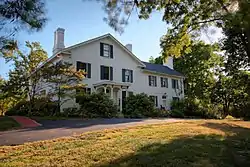 Rubicon Farm |
September 29, 1976 (#76001500) |
1815 Brown St. 39°44′04″N 84°10′56″W |
|
| 80 | Sachs and Pruden Ale Company Building |  Sachs and Pruden Ale Company Building |
August 12, 1991 (#91000973) |
127 Wyandot St. 39°45′30″N 84°11′15″W |
Currently houses the Dayton Metro Library's Operations Center. From the 1980s through 2014 it was the long-time home of Hauer Music. |
| 81 | Sacred Heart Church | 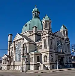 Sacred Heart Church |
October 22, 1987 (#87001885) |
217 W. 4th St. 39°45′28″N 84°11′43″W |
|
| 82 | St. Adalbert Polish Catholic Church | 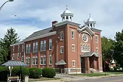 St. Adalbert Polish Catholic Church |
November 7, 1991 (#91001581) |
1511 Valley St. 39°47′01″N 84°09′22″W |
|
| 83 | Saint Anne's Hill Historic District | 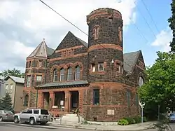 Saint Anne's Hill Historic District |
June 5, 1986 (#86001214) |
Roughly bounded by 4th, McClure, Josie, High, and Dutoit Sts. 39°45′24″N 84°10′23″W |
|
| 84 | St. Mary Roman Catholic Church |  St. Mary Roman Catholic Church |
April 21, 1983 (#83002012) |
543 Xenia Ave. 39°45′10″N 84°10′04″W |
|
| 85 | St. Mary's Hall, University of Dayton |  St. Mary's Hall, University of Dayton |
May 25, 1973 (#73001508) |
300 College Park 39°44′22″N 84°10′41″W |
|
| 86 | Hyman Schriber Building |  Hyman Schriber Building |
May 26, 1988 (#88000667) |
306-308 Washington St. 39°45′06″N 84°11′41″W |
|
| 87 | Shawen Acres |  Shawen Acres |
October 9, 1991 (#91001487) |
3304 N. Main St. 39°47′47″N 84°12′53″W |
|
| 88 | Sig's General Store |  Sig's General Store |
August 12, 1991 (#91000974) |
1400 Valley St. 39°46′54″N 84°09′30″W |
|
| 89 | Edwin Smith House |  Edwin Smith House |
August 13, 1974 (#74001582) |
131 W. 3rd St. 39°45′32″N 84°11′42″W |
|
| 90 | South Park Historic District | 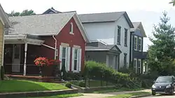 South Park Historic District |
August 23, 1984 (#84003794) |
Roughly bounded by Park, Morton, Hickory, and Wayne Ave.; also roughly bounded by Wayne, Wyoming, Nathan, Oak, Alberta and Blaine 39°44′56″N 84°10′43″W |
Second set of boundaries represents a boundary increase of June 16, 1988 |
| 91 | Southern Ohio Lunatic Asylum | 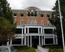 Southern Ohio Lunatic Asylum |
November 15, 1979 (#79001902) |
2335 Wayne Ave. 39°44′16″N 84°09′40″W |
|
| 92 | Squirrel-Forest Historic District |  Squirrel-Forest Historic District |
October 14, 2010 (#10000827) |
North of Homewood Ave. and along the west side of Forest Ave. 39°46′27″N 84°12′08″W |
|
| 93 | Steele's Hill-Grafton Hill Historic District | 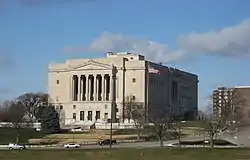 Steele's Hill-Grafton Hill Historic District |
June 5, 1986 (#86001237) |
Roughly bounded by Grand, Plymouth, Forest, and Salem 39°45′59″N 84°12′15″W |
|
| 94 | John S. Stengel House |  John S. Stengel House |
April 21, 1983 (#83002013) |
325 W. 2nd St. 39°45′37″N 84°11′52″W |
Demolished |
| 95 | Stivers High School |  Stivers High School |
August 17, 2001 (#01000896) |
1313 E. 5th St. 39°45′31″N 84°10′32″W |
|
| 96 | Summit Street Young Women's Christian Association (YWCA) | January 16, 2020 (#100004870) |
236 South Paul Laurence Dunbar St. 39°45′08″N 84°13′05″W |
||
| 97 | Traxler Mansion |  Traxler Mansion |
April 24, 1979 (#79001903) |
42 Yale Ave. 39°46′14″N 84°12′54″W |
|
| 98 | Unit III, Dayton Project |  Unit III, Dayton Project |
June 7, 2006 (#06000480) |
1601 W. 1st St. 39°45′25″N 84°13′19″W |
|
| 99 | United Brethren Publishing House | 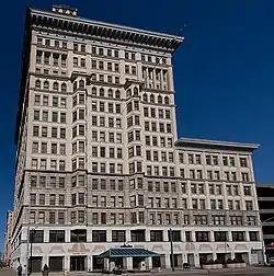 United Brethren Publishing House |
December 10, 1993 (#93001391) |
40-46 S. Main St. (7-21 E. 4th St.) 39°45′30″N 84°11′29″W |
|
| 100 | Victory Theater Building | 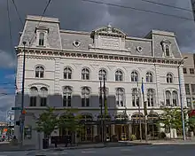 Victory Theater Building |
June 22, 1972 (#72001037) |
138 N. Main St. 39°45′42″N 84°11′32″W |
|
| 101 | Dr. Jefferson A. Walters House |  Dr. Jefferson A. Walters House |
November 20, 1974 (#74001583) |
35 E. 1st St. 39°45′46″N 84°11′29″W |
|
| 102 | West Third Street Historic District | .jpg.webp) West Third Street Historic District |
January 25, 1989 (#88003194) |
Roughly W. 3rd St. between Broadway and Shannon St. 39°45′21″N 84°12′43″W |
|
| 103 | Westbrock Funeral Home |  Westbrock Funeral Home |
March 10, 1988 (#88000205) |
1712 Wayne Ave. 39°44′41″N 84°10′06″W |
|
| 104 | Weustoff and Getz Company |  Weustoff and Getz Company |
September 3, 2014 (#14000547) |
210 Wayne Ave. 39°45′31″N 84°11′00″W |
|
| 105 | Women's Christian Association |  Women's Christian Association |
May 13, 1976 (#76001501) |
800 W. 5th St. 39°45′11″N 84°12′28″W |
Razed in November 2007 |
| 106 | Woodland Cemetery Association of Dayton Historic District | 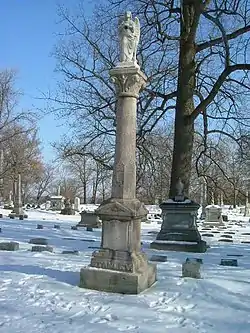 Woodland Cemetery Association of Dayton Historic District |
November 22, 2011 (#11000855) |
118 Woodland Ave. 39°44′38″N 84°10′30″W |
|
| 107 | Woodland Cemetery Gateway, Chapel and Office |  Woodland Cemetery Gateway, Chapel and Office |
November 30, 1978 (#78002147) |
118 Woodland Ave. 39°44′34″N 84°10′45″W |
|
| 108 | Wright Company Factory | September 9, 2019 (#100004355) |
2701 Home Ave., Dayton Aviation Heritage National Historical Park 39°44′50″N 84°14′20″W |
||
| 109 | Wright Cycle Company-Wright and Wright Printing Offices |  Wright Cycle Company-Wright and Wright Printing Offices |
February 13, 1986 (#86000236) |
22 S. Williams St. 39°45′13″N 84°12′43″W |
|
| 110 | Wright Flyer III | 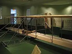 Wright Flyer III |
June 21, 1990 (#90001747) |
Carillon Park, 2001 S. Patterson Boulevard 39°43′40″N 84°12′07″W |
Former listings
| [3] | Name on the Register | Image | Date listed | Date removed | Location | Summary |
|---|---|---|---|---|---|---|
| 1 | Classic Theater | February 10, 1975 (#75001496) | January 31, 1995 | 815 W. 5th St. 39°45′12″N 84°12′30″W |
||
| 2 | Orville Wright Laboratory | April 13, 1973 (#73001509) | February 20, 1980 | 15 N. Broadway |
See also
| Wikimedia Commons has media related to National Register of Historic Places in Dayton, Ohio. |
References
- The latitude and longitude information provided in this table was derived originally from the National Register Information System, which has been found to be fairly accurate for about 99% of listings. Some locations in this table may have been corrected to current GPS standards.
- "National Register of Historic Places: Weekly List Actions". National Park Service, United States Department of the Interior. Retrieved on January 29, 2021.
- Numbers represent an alphabetical ordering by significant words. Various colorings, defined here, differentiate National Historic Landmarks and historic districts from other NRHP buildings, structures, sites or objects.
- "National Register Information System". National Register of Historic Places. National Park Service. April 24, 2008.
- The eight-digit number below each date is the number assigned to each location in the National Register Information System database, which can be viewed by clicking the number.
- Wynn, Kelli. Carillon Park Gets Historic Homes Sunday, Dayton Daily News, 2009-07-10. Accessed 2012-12-30.
- Location derived from this SunWatch website; the NRIS lists it as "Address Restricted"
- McCarty, Mary. "Community makes final pilgrimage to historic Julienne High School". Dayton Daily News. Archived from the original on May 3, 2012. Retrieved November 15, 2016.
- Location derived from Allman, John C. "A New Late Woodland Culture for Ohio: The Lichliter Village Site Near Dayton". Ohio Archaeologist 7.2 (1957): 59. The NRIS lists the site as "Address Restricted".
- Location, Dayton International Peace Museum, 2010. Accessed 2012-11-27. The NRIS lists the house at its former location of 319 W. 3rd St.
