National Register of Historic Places listings in Akron, Ohio
This is a list of the National Register of Historic Places listings in Akron, Ohio.

This is intended to be a complete list of the properties and districts on the National Register of Historic Places in Akron, Ohio, United States. Latitude and longitude coordinates are provided for many National Register properties and districts; these locations may be seen together in an online map.[1]
There are 177 properties and districts listed on the National Register in Summit County, including 3 National Historic Landmarks. The city of Akron is the location of 58 of these properties and districts, including 2 of the National Historic Landmarks; they are listed here, while the 120 sites and 1 National Historic Landmark located elsewhere in Summit County are listed separately. One district, the Valley Railway Historic District, is split between Akron and other parts of the county, and is thus included on both lists.
- This National Park Service list is complete through NPS recent listings posted January 29, 2021.[2]
Current listings
| [3] | Name on the Register | Image | Date listed[4] | Location | Description |
|---|---|---|---|---|---|
| 1 | Akron Jewish Center | 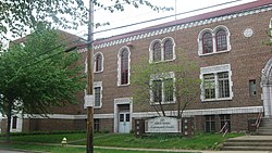 Akron Jewish Center |
July 24, 1986 (#86001919) |
220 S. Balch St. 41°05′11″N 81°32′04″W |
|
| 2 | Akron Post Office and Federal Building | 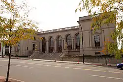 Akron Post Office and Federal Building |
May 26, 1983 (#83002059) |
168 E. Market St. 41°05′00″N 81°30′49″W |
|
| 3 | Akron Public Library | .jpg.webp) Akron Public Library |
January 19, 1983 (#83002060) |
69 E. Market St. 41°05′06″N 81°30′52″W |
|
| 4 | Akron Rural Cemetery Buildings | 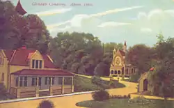 Akron Rural Cemetery Buildings |
September 27, 1980 (#80003236) |
150 Glendale Ave. 41°05′05″N 81°31′32″W |
|
| 5 | Akron Soap Company | 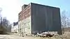 Akron Soap Company |
September 29, 2014 (#14000811) |
237-243 Furnace St. 41°05′20″N 81°30′26″W |
|
| 6 | Akron Y.M.C.A. Building | 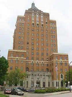 Akron Y.M.C.A. Building |
October 31, 1980 (#80003237) |
80 W. Center St. 41°04′49″N 81°31′24″W |
|
| 7 | Akron-Fulton International Airport Administration Building |  Akron-Fulton International Airport Administration Building |
December 21, 2001 (#01001361) |
1800 Triplett Boulevard 41°02′31″N 81°27′47″W |
|
| 8 | B.F. Goodrich Company Historic District | December 21, 2020 (#100005529) |
520-540 South Main Street; 115-123 West Bartges Street 41°04′15″N 81°31′35″W |
||
| 8 | Byron R. Barder House |  Byron R. Barder House |
September 17, 1987 (#87001598) |
1041 W. Market St. 41°06′01″N 81°33′00″W |
|
| 9 | Stacy G. Carkhuff House |  Stacy G. Carkhuff House |
August 30, 1984 (#84003804) |
1225 W. Market St. 41°06′11″N 81°33′15″W |
|
| 10 | Cascade Locks Historic District | 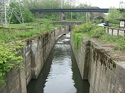 Cascade Locks Historic District |
December 10, 1992 (#92001627) |
Roughly bounded by North, Howard, Innerbelt State Route 59, and the canal from Locks 10 to 16, including discontiguous parts north 41°05′35″N 81°31′16″W |
|
| 11 | Cole Avenue Housing Project Historic District | 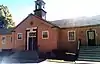 Cole Avenue Housing Project Historic District |
October 17, 2007 (#07001090) |
744 Colette Dr. 41°03′05″N 81°30′07″W |
|
| 12 | Eagles Temple | Eagles Temple |
June 1, 1982 (#82003656) |
131-137 E. Market St. 41°05′03″N 81°30′48″W |
|
| 13 | East Market Street Church of Christ | 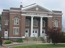 East Market Street Church of Christ |
February 7, 1989 (#88003440) |
864 E. Market St. 41°04′22″N 81°29′30″W |
|
| 14 | Firestone Tire and Rubber Company |  Firestone Tire and Rubber Company |
June 20, 2014 (#14000338) |
1200 Firestone Parkway 41°03′06″N 81°31′50″W |
|
| 15 | First Congregational Church | 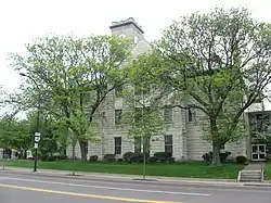 First Congregational Church |
February 20, 2004 (#04000061) |
292 E. Market St. 41°04′53″N 81°30′31″W |
|
| 16 | First National Bank Tower | .jpg.webp) First National Bank Tower |
June 27, 2007 (#07000633) |
106 S. Main St. 41°04′56″N 81°31′08″W |
now the Huntington Tower |
| 17 | Jacob M. Gayer House |  Jacob M. Gayer House |
October 18, 1984 (#84003442) |
406 Sumner St. 41°04′19″N 81°30′53″W |
|
| 18 | Glendale Cemetery |  Glendale Cemetery |
September 28, 2001 (#01001063) |
150 Glendale Ave. 41°05′02″N 81°31′44″W |
|
| 19 | Goodyear Airdock | 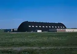 Goodyear Airdock |
April 11, 1973 (#73002259) |
Southern side of the Akron Airport 41°01′55″N 81°28′15″W |
|
| 20 | Goodyear Hall-Ohio Savings and Trust Company | _and_Goodyear_Hall_(rear)%252C_Akron%252C_Ohio_-_20200926.jpg.webp) Goodyear Hall-Ohio Savings and Trust Company |
February 24, 2014 (#14000030) |
1201 E. Market St. 41°04′00″N 81°28′58″W |
|
| 21 | Goodyear Tire and Rubber Company Headquarters | 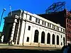 Goodyear Tire and Rubber Company Headquarters |
August 27, 2013 (#13000683) |
1144 E. Market St. 41°03′56″N 81°28′58″W |
|
| 22 | The Gothic Building | 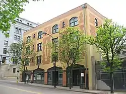 The Gothic Building |
May 21, 2010 (#10000280) |
102 S. High St. and 52-58 E. Mill St. 41°04′55″N 81°31′01″W |
|
| 23 | Grace Reformed Church | Grace Reformed Church |
July 19, 1984 (#84003806) |
172 W. Bowery St. 41°04′48″N 81°31′28″W |
|
| 24 | Hall Park Allotment Historic District | 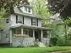 Hall Park Allotment Historic District |
October 31, 2002 (#02001274) |
Roughly along Oakdale Ave., from Crestwood Ave. and Crosby St. 41°05′20″N 81°32′00″W |
|
| 25 | Hower Mansion |  Hower Mansion |
April 11, 1973 (#73001536) |
60 Fir Hill 41°04′46″N 81°30′28″W |
|
| 26 | Andrew Jackson House | 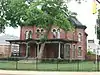 Andrew Jackson House |
February 13, 1975 (#75001537) |
277 E. Mill St. 41°04′48″N 81°30′34″W |
|
| 27 | Kenmore Boulevard Historic District | September 6, 2019 (#100004354) |
Roughly bounded by 872-1030; 873-1017 Kenmore Blvd.; 2181 14th St. SW; 2200 15th St. SW; 940 Florida Ave. 41°02′34″N 81°33′37″W |
||
| 28 | Loew's Theatre | .jpg.webp) Loew's Theatre |
July 16, 1973 (#73001537) |
182 S. Main St. 41°04′51″N 81°31′13″W |
|
| 29 | Main Exchange Historic District |  Main Exchange Historic District |
November 12, 2009 (#09000912) |
1 W. Exchange St., 323-337 S. Main St., 12 E. Exchange St., 380-348 S. Main St., and 328-326 S. Main St. 41°04′36″N 81°31′20″W |
|
| 30 | Main-Market Historic District |  Main-Market Historic District |
August 1, 2003 (#03000719) |
15-47 N. Main St., 1-39 S. Main St., 39-168 E. Market St., 18-42 N. High St., and 70 Broadway St. 41°05′06″N 81°30′59″W |
|
| 31 | Wells E. Merriman House | 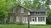 Wells E. Merriman House |
September 29, 1983 (#83002061) |
641 W. Market St. 41°05′40″N 81°32′16″W |
|
| 32 | Lewis Miller House | 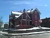 Lewis Miller House |
January 30, 1976 (#76001531) |
142 King Dr. 41°05′04″N 81°31′23″W |
|
| 33 | O'Neil's Department Store | 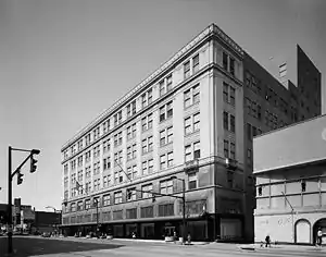 O'Neil's Department Store |
November 28, 1990 (#90001776) |
226-250 S. Main St. 41°04′46″N 81°31′24″W |
|
| 34 | Old Akron Post Office | 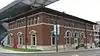 Old Akron Post Office |
June 19, 1972 (#72001046) |
70 E. Market St. 41°05′04″N 81°30′55″W |
|
| 35 | Col. Simon Perkins Mansion | 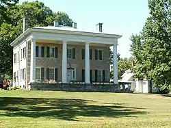 Col. Simon Perkins Mansion |
August 13, 1974 (#74001624) |
550 Copley Rd. 41°05′06″N 81°32′30″W |
|
| 36 | Portage Hotel | October 17, 1988 (#80004611) |
10 N. Main St. 41°05′08″N 81°31′01″W |
||
| 37 | Quaker Oats Cereal Factory |  Quaker Oats Cereal Factory |
December 8, 1978 (#78002195) |
120 E. Mill St. 41°04′50″N 81°30′56″W |
|
| 38 | The Rhodes and Watters Apartment Buildings | 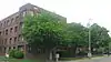 The Rhodes and Watters Apartment Buildings |
December 20, 2007 (#07001296) |
614, 608, 610, and 612 W. Market St., and 16 Rhodes Ave. 41°05′37″N 81°32′14″W |
|
| 39 | Byron W. Robinson House | 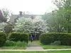 Byron W. Robinson House |
September 20, 1991 (#91001415) |
715 E. Buchtel Ave. 41°04′37″N 81°29′43″W |
|
| 40 | Charles Willard Seiberling House |  Charles Willard Seiberling House |
May 6, 1993 (#93000405) |
1075 W. Market St. 41°06′06″N 81°33′05″W |
|
| 41 | Selle Gear Company | 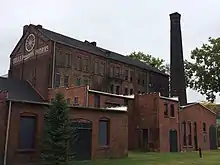 Selle Gear Company |
November 9, 2005 (#05001213) |
451 S. High St. 41°04′25″N 81°31′20″W |
|
| 42 | Dr. Louis Sisler House | June 7, 2019 (#100004056) |
675 N. Portage Path 41°06′58″N 81°32′49″W |
||
| 43 | Dr. Robert Smith House | 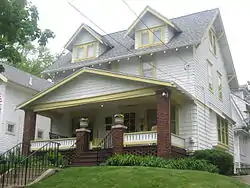 Dr. Robert Smith House |
October 31, 1985 (#85003411) |
855 Ardmore Ave. 41°05′45″N 81°32′58″W |
Designated a National Historic Landmark on October 16, 2012 |
| 44 | South Main Street Historic District | 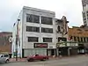 South Main Street Historic District |
July 2, 2008 (#08000622) |
156-222 S. Main St., 153-279 S. Main St. 41°04′46″N 81°31′12″W |
|
| 45 | St. Bernard's Church | .jpg.webp) St. Bernard's Church |
March 9, 1989 (#89000174) |
240 S. Broadway St. 41°04′41″N 81°31′07″W |
|
| 46 | St. Paul's Sunday School and Parish House | .jpg.webp) St. Paul's Sunday School and Parish House |
November 7, 1976 (#76001532) |
E. Market and Forge Sts. 41°04′51″N 81°30′25″W |
|
| 47 | Stan Hywet Hall-Frank A. Seiberling House | 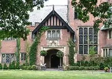 Stan Hywet Hall-Frank A. Seiberling House |
January 17, 1975 (#75002058) |
714 N. Portage Path 41°07′07″N 81°33′05″W |
|
| 48 | Stan Hywet Poultry Keepers Cottage |  Stan Hywet Poultry Keepers Cottage |
January 14, 2013 (#12001183) |
1103 Courtleigh Dr. 41°07′06″N 81°33′12″W |
|
| 49 | Summit County Courthouse and Annex | 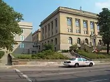 Summit County Courthouse and Annex |
October 15, 1974 (#74001625) |
209 S. High St. 41°04′46″N 81°31′02″W |
|
| 50 | University Club | December 2, 2019 (#100004706) |
105 Fir Hill 41°04′42″N 81°30′24″W |
||
| 51 | Valley Railway Historic District | 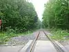 Valley Railway Historic District |
May 17, 1985 (#85001123) |
Cuyahoga Valley between Rockside Rd. in the Cuyahoga Valley National Park and Howard St. at Little Cuyahoga Valley 41°13′38″N 81°34′13″W |
Extends into other parts of Summit County and into Cuyahoga County |
| 52 | Viall Lodge |  Viall Lodge |
March 17, 1994 (#94000238) |
1135 E. Market St. 41°04′05″N 81°29′04″W |
|
| 53 | Werner Company Building | 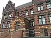 Werner Company Building |
December 12, 1976 (#76001533) |
109 N. Union 41°05′03″N 81°30′21″W |
|
| 54 | Edward P. Werner House | 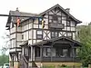 Edward P. Werner House |
October 4, 2005 (#05001146) |
258 W. Market St. 41°05′20″N 81°31′34″W |
|
| 55 | Wesley Temple AME Zion Church | 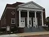 Wesley Temple AME Zion Church |
March 17, 1994 (#94000243) |
104 N. Prospect St. 41°05′10″N 81°30′38″W |
|
| 56 | Westmont Building | 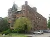 Westmont Building |
May 31, 1984 (#84003807) |
22 Rhodes Ave. 41°05′35″N 81°32′15″W |
|
| 57 | Young Women's Christian Association |  Young Women's Christian Association |
November 4, 1982 (#82001491) |
146 S. High St. 41°04′52″N 81°31′03″W |
See also
| Wikimedia Commons has media related to National Register of Historic Places in Akron, Ohio. |
References
- The latitude and longitude information provided in this table was derived originally from the National Register Information System, which has been found to be fairly accurate for about 99% of listings. Some locations in this table may have been corrected to current GPS standards.
- "National Register of Historic Places: Weekly List Actions". National Park Service, United States Department of the Interior. Retrieved on January 29, 2021.
- Numbers represent an alphabetical ordering by significant words. Various colorings, defined here, differentiate National Historic Landmarks and historic districts from other NRHP buildings, structures, sites or objects.
- The eight-digit number below each date is the number assigned to each location in the National Register Information System database, which can be viewed by clicking the number.
