National Register of Historic Places listings in Medina County, Ohio
This is a list of the National Register of Historic Places listings in Medina County, Ohio.
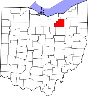
Location of Medina County in Ohio
This is intended to be a complete list of the properties and districts on the National Register of Historic Places in Medina County, Ohio, United States. The locations of National Register properties and districts for which the latitude and longitude coordinates are included below, may be seen in an online map.[1]
There are 31 properties and districts listed on the National Register in the county. Another property was once listed but has been removed.
- This National Park Service list is complete through NPS recent listings posted January 29, 2021.[2]
Current listings
| [3] | Name on the Register[4] | Image | Date listed[5] | Location | City or town | Description |
|---|---|---|---|---|---|---|
| 1 | Black River Viaduct, Baltimore and Ohio Railroad |  Black River Viaduct, Baltimore and Ohio Railroad |
May 6, 1976 (#76001488) |
1 mi (1.6 km) west of Lodi off State Route 421 41°01′38″N 82°02′29″W |
Harrisville Township | |
| 2 | H.G. Blake House |  H.G. Blake House |
September 30, 1982 (#82003612) |
314 E. Washington St. 41°08′16″N 81°51′36″W |
Medina | |
| 3 | Burritt Blakslee House |  Burritt Blakslee House |
December 4, 1974 (#74001573) |
3756 Fenn Rd., northeast of Medina 41°10′14″N 81°49′17″W |
Medina Township | |
| 4 | George Burr House |  George Burr House |
May 3, 1976 (#76001489) |
740 Wooster Rd. 41°01′29″N 81°59′50″W |
Lodi | |
| 5 | Matthew Chandler House |  Matthew Chandler House |
March 30, 1978 (#78002134) |
South of Sharon Center at 6908 Ridge Rd. 41°05′11″N 81°44′10″W |
Sharon Township | |
| 6 | Zimri Cook House |  Zimri Cook House |
June 22, 1976 (#76001487) |
6999 Spieth Rd. in Lester 41°10′52″N 81°56′24″W |
York Township | |
| 7 | Charles Frank House and Store | _1.jpg.webp) Charles Frank House and Store |
September 5, 1975 (#75001485) |
West of Valley City at the junction of State Route 303 and County Route 23 41°14′14″N 81°57′15″W |
Liverpool Township | |
| 8 | Jacob Gayer House |  Jacob Gayer House |
June 22, 1979 (#79001894) |
North of Medina at 4508 Marks Rd. 41°09′08″N 81°52′43″W |
Medina Township | |
| 9 | Halsey Hulburt Homestead | 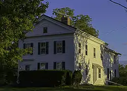 Halsey Hulburt Homestead |
December 1, 1988 (#88002747) |
5484 Seville Rd., west of Seville 41°00′41″N 81°53′13″W |
Guilford Township | |
| 10 | King-Phillips-Deibel House |  King-Phillips-Deibel House |
December 16, 1982 (#82001472) |
506 N. Broadway St. 41°08′40″N 81°51′45″W |
Medina | |
| 11 | Medfair Heights Apartment Historic District | 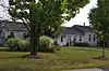 Medfair Heights Apartment Historic District |
July 2, 2008 (#08000624) |
221 N. State St. 41°08′28″N 81°52′47″W |
Medina | |
| 12 | Medina County Courthouse |  Medina County Courthouse |
July 16, 1970 (#70000507) |
Liberty St. and Broadway, Public Sq. 41°08′20″N 81°51′45″W |
Medina | |
| 13 | Medina Farmers Exchange Co. |  Medina Farmers Exchange Co. |
February 14, 2018 (#100002123) |
320 S. Court St. 41°08′08″N 81°51′50″W |
Medina | |
| 14 | Medina Masonic Temple and Medina Theater | 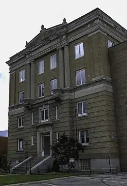 Medina Masonic Temple and Medina Theater |
October 22, 2002 (#02001210) |
120 N. Elmwood Ave. and 139 W. Liberty St. 41°08′23″N 81°51′56″W |
Medina | Torn down in late 2016 |
| 15 | Medina Public Square Historic District |  Medina Public Square Historic District |
June 11, 1975 (#75001483) |
Public Sq. and surrounding properties 41°08′19″N 81°51′49″W |
Medina | |
| 16 | Judge Albert Munson House |  Judge Albert Munson House |
November 26, 1980 (#80003156) |
141 S. Prospect St.[6] 41°08′19″N 81°52′17″W |
Medina | Previously located at 231 E. Washington St.;[4] relocated to prevent destruction[6] |
| 17 | Paleo Crossing Site | 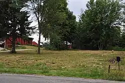 Paleo Crossing Site |
July 30, 1992 (#92000972) |
Northwest of the junction of Ridgewood and State Rds.[7] 41°07′20″N 81°43′13″W |
Sharon Township | |
| 18 | Parmelee House |  Parmelee House |
November 29, 1979 (#79001895) |
1328 W. River Rd. in Valley City 41°14′18″N 81°55′51″W |
Liverpool Township | |
| 19 | A.I. and E.R. Root Homestead |  A.I. and E.R. Root Homestead |
June 10, 1975 (#75001484) |
662 W. Liberty St. 41°08′20″N 81°52′29″W |
Medina | |
| 20 | St. Mark's Episcopal Church |  St. Mark's Episcopal Church |
February 6, 1973 (#73001506) |
146 College St. 41°01′33″N 81°43′53″W |
Wadsworth | |
| 21 | St. Martin's Catholic Church | _1.jpg.webp) St. Martin's Catholic Church |
November 12, 1975 (#75001486) |
Southwest of Valley City on Station Rd. (County Road 23) 41°13′30″N 81°57′18″W |
Liverpool Township | |
| 22 | St. Paul's Episcopal Church |  St. Paul's Episcopal Church |
June 1, 1982 (#82003613) |
317 E. Liberty St. 41°08′22″N 81°51′38″W |
Medina | |
| 23 | Seville Inn | August 28, 2020 (#100005486) |
39 West Main St. 41°00′36″N 81°51′49″W |
Seville | ||
| 24 | Seville Jail | 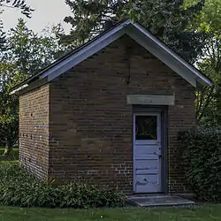 Seville Jail |
September 26, 1997 (#97001135) |
70 W. Main St. 41°00′37″N 81°52′00″W |
Seville | |
| 25 | William H. Seymour House | 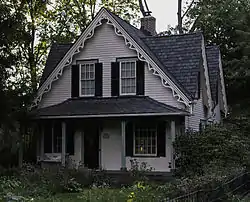 William H. Seymour House |
June 4, 1979 (#79001896) |
3306 S. Weymouth Rd. at Weymouth 41°11′07″N 81°47′41″W |
Medina Township | |
| 26 | Sharon Center Public Square Historic District | 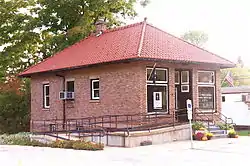 Sharon Center Public Square Historic District |
October 3, 1980 (#80003157) |
State Routes State Route 94 and 162 in Sharon Center 41°05′57″N 81°44′09″W |
Sharon Township | |
| 27 | Spring Grove Cemetery |  Spring Grove Cemetery |
June 7, 2006 (#06000482) |
Spring Grove St. 41°08′22″N 81°51′06″W |
Medina | |
| 28 | United States Post Office | August 20, 2019 (#100004307) |
143 West Liberty St. 41°08′21″N 81°51′57″W |
Medina | Now the Donald J. Pease Federal Building. | |
| 29 | Universalist Church Of Westfield Center | 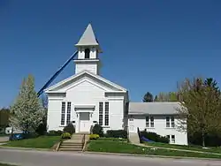 Universalist Church Of Westfield Center |
November 29, 1978 (#78002135) |
LeRoy and Greenwich Rds. 41°01′39″N 81°55′59″W |
Westfield Center | |
| 30 | Wheeling and Lake Erie Railroad Depot |  Wheeling and Lake Erie Railroad Depot |
January 23, 2013 (#12001215) |
204 Railroad St. 41°01′50″N 82°00′46″W |
Lodi | |
| 31 | York United Methodist Church | 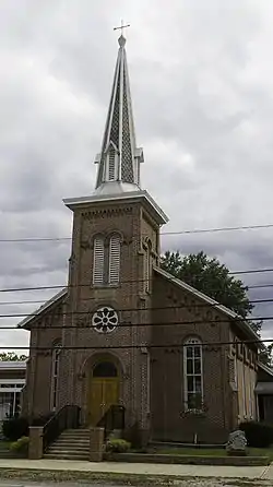 York United Methodist Church |
February 17, 1978 (#78002133) |
Norwalk Rd. in Mallet Creek 41°10′01″N 81°55′29″W |
York Township |
Former listing
| [3] | Name on the Register | Image | Date listed | Date removed | Location | City or town | Summary |
|---|---|---|---|---|---|---|---|
| 1 | Brunswick Town Hall and School | Unavailable (#75002167) | 1976 | 1380 Pearl Rd. 41°14′19″N 81°50′30″W |
York Township |
See also
| Wikimedia Commons has media related to National Register of Historic Places in Medina County, Ohio. |
References
- The latitude and longitude information provided in this table was derived originally from the National Register Information System, which has been found to be fairly accurate for about 99% of listings. Some locations in this table may have been corrected to current GPS standards.
- "National Register of Historic Places: Weekly List Actions". National Park Service, United States Department of the Interior. Retrieved on January 29, 2021.
- Numbers represent an alphabetical ordering by significant words. Various colorings, defined here, differentiate National Historic Landmarks and historic districts from other NRHP buildings, structures, sites or objects.
- "National Register Information System". National Register of Historic Places. National Park Service. March 13, 2009.
- The eight-digit number below each date is the number assigned to each location in the National Register Information System database, which can be viewed by clicking the number.
- Preserving Medina's Heritage Archived 2015-02-13 at the Wayback Machine, Medina Community Design Committee, n.d. Accessed 2013-09-09.
- Location derived from the Rose of Sharon Subdivision Preliminary Plan, Medina County Planning Commission, 2005-04-06. Accessed 2009-08-03. The NRIS lists the site as "Address Restricted".

Municipalities and communities of Medina County, Ohio, United States | ||
|---|---|---|
| Cities | Map of Ohio highlighting Medina County | |
| Villages | ||
| Townships | ||
| Unincorporated communities | ||
| Footnotes | ‡This populated place also has portions in an adjacent county or counties | |
| ||
This article is issued from Wikipedia. The text is licensed under Creative Commons - Attribution - Sharealike. Additional terms may apply for the media files.