National Register of Historic Places listings in Muskingum County, Ohio
This is a list of the National Register of Historic Places listings in Muskingum County, Ohio.
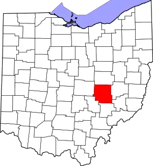
Location of Muskingum County in Ohio
This is intended to be a complete list of the properties and districts on the National Register of Historic Places in Muskingum County, Ohio, United States. Latitude and longitude coordinates are provided for many National Register properties and districts; these locations may be seen together in an online map.[1]
There are 80 properties and districts listed on the National Register in the county. Another 5 properties were once listed but have been removed.
- This National Park Service list is complete through NPS recent listings posted January 29, 2021.[2]
Current listings
| [3] | Name on the Register[4] | Image | Date listed[5] | Location | City or town | Description |
|---|---|---|---|---|---|---|
| 1 | Adams-Gray House |  Adams-Gray House |
December 5, 1979 (#79001797) |
Southeast of Trinway on Tobacco Hill Rd.ja 40°09′31″N 81°56′54″W |
Cass Township | Extends into Virginia Township in Coshocton County |
| 2 | George W. Adams House | November 29, 1979 (#79001912) |
South of Trinway on Bottom Rd. 40°07′54″N 82°00′57″W |
Cass Township | Demolished in 2013. | |
| 3 | Adena Court Apartments |  Adena Court Apartments |
September 27, 1980 (#80003190) |
41 S. 4th St. 39°56′22″N 82°00′29″W |
Zanesville | |
| 4 | Alameda Apartments |  Alameda Apartments |
June 17, 1982 (#82003623) |
7th St. 39°56′40″N 82°00′15″W |
Zanesville | |
| 5 | Arlington Hotel |  Arlington Hotel |
December 16, 1982 (#82001482) |
722 Main St. 39°56′24″N 82°00′14″W |
Zanesville | Destroyed |
| 6 | Baughman Memorial Park | August 27, 1979 (#79001909) |
West of Frazeysburg on State Route 586 40°06′41″N 82°10′37″W |
Jackson Township | The park, home to sandstone statues sculpted by local artist Brice Baughman, was sold in February 2008 and resold six months later, at that time twelve of the statues were individually sold.[6] | |
| 7 | Belt Line and New York Central Freight House |  Belt Line and New York Central Freight House |
March 24, 1983 (#83002015) |
3rd and Market Sts. 39°56′32″N 82°00′33″W |
Zanesville | |
| 8 | Black-Elliott Block | 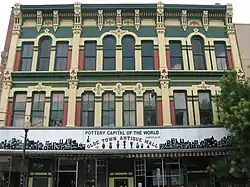 Black-Elliott Block |
May 8, 1979 (#79001914) |
525 Main St. 39°56′25″N 82°00′21″W |
Zanesville | |
| 9 | Blocksom-Rolls House |  Blocksom-Rolls House |
February 21, 1979 (#79001915) |
960 Eastman St. 39°56′34″N 81°59′59″W |
Zanesville | |
| 10 | Charles Brendel House |  Charles Brendel House |
November 25, 1980 (#80003191) |
427 Wayne Ave. 39°56′02″N 82°00′10″W |
Zanesville | |
| 11 | Brighton-Dryden Historic District |  Brighton-Dryden Historic District |
June 1, 1982 (#82003624) |
Dryden Rd., Brighton Boulevard, and Lexington and Stanberry Aves. 39°55′47″N 82°01′21″W |
Zanesville | |
| 12 | Buckingham-Petty House | August 11, 1980 (#80003182) |
Mound Rd. 39°52′51″N 81°54′49″W |
Wayne Township | ||
| 13 | Nicholas Christman House |  Nicholas Christman House |
May 22, 1978 (#78002159) |
532 Wayne Ave. 39°55′51″N 82°00′05″W |
Zanesville | |
| 14 | Howard Chandler Christy Art Studio | 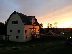 Howard Chandler Christy Art Studio |
June 15, 2011 (#11000368) |
6020 S. River Rd., north of Blue Rock 39°51′22″N 81°53′52″W |
Wayne Township | 1908-1909 estate of Howard Chandler Christy; also known as The Barracks[7] |
| 15 | Clossman Hardware Store |  Clossman Hardware Store |
November 25, 1980 (#80003192) |
621-623 Main St. 39°56′24″N 82°00′18″W |
Zanesville | |
| 16 | Crescent Hill |  Crescent Hill |
January 9, 1986 (#86000034) |
44 W. 5th St. 40°07′23″N 82°00′57″W |
Dresden | |
| 17 | William Denison House |  William Denison House |
April 29, 1982 (#82003620) |
7115 Adamsville Rd. (State Route 93), south of Adamsville 40°03′08″N 81°53′35″W |
Salem Township | |
| 18 | Dresden Suspension Bridge | 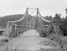 Dresden Suspension Bridge |
December 1, 1978 (#78002153) |
State Routes 208 and 666 40°07′14″N 82°00′01″W |
Dresden and Madison Township | |
| 19 | Factory Site |  Factory Site |
March 11, 1980 (#80003183) |
Along Moxahala Creek in Ironspot 39°49′13″N 82°03′51″W |
Newton Township | |
| 20 | Fairmont Avenue Historic District |  Fairmont Avenue Historic District |
November 30, 1982 (#82001483) |
Fairmont Ave. 39°57′31″N 82°00′47″W |
Zanesville | |
| 21 | Five Mile House | April 11, 1977 (#77001081) |
South of Zanesville off U.S. Route 22 39°52′55″N 82°03′32″W |
Newton Township | ||
| 22 | James Galigher House |  James Galigher House |
February 22, 1979 (#79001916) |
South of Zanesville on S. River Rd. 39°53′55″N 81°59′56″W |
Wayne Township | |
| 23 | John Glenn Boyhood Home |  John Glenn Boyhood Home |
December 10, 2018 (#100003210) |
72 W. Main St. 39°59′37″N 81°44′11″W |
New Concord | |
| 24 | Ernest J. Gorsuch House |  Ernest J. Gorsuch House |
March 11, 1980 (#80003193) |
1869 Norwood Boulevard 39°57′47″N 82°00′19″W |
Zanesville | |
| 25 | Ralph Hardesty Stone House | 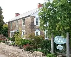 Ralph Hardesty Stone House |
March 11, 1980 (#80003184) |
Main St. 39°59′08″N 81°47′24″W |
Norwich | |
| 26 | William Rainey Harper Log House | 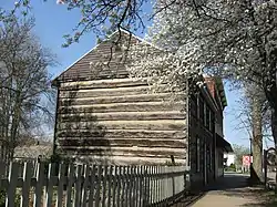 William Rainey Harper Log House |
April 6, 1978 (#78002154) |
E. Main St. 39°59′38″N 81°44′05″W |
New Concord | |
| 27 | Harper-Cosgrave Block |  Harper-Cosgrave Block |
January 3, 1980 (#80003195) |
62 N. 3rd St.[8] 39°56′30″N 82°00′32″W |
Zanesville | |
| 28 | William B. Harris House |  William B. Harris House |
May 22, 1978 (#78002161) |
1320 Newman Dr. 39°56′24″N 81°59′28″W |
Zanesville | |
| 29 | Headley Inn, Smith House and Farm |  Headley Inn, Smith House and Farm |
April 26, 1978 (#78002162) |
5255 West Pike 39°57′14″N 82°05′39″W |
Falls Township | |
| 30 | James Hunter Stone House | January 3, 1980 (#80003181) |
East of Adamsville on Mercer Rd. 40°05′35″N 81°48′15″W |
Monroe Township | ||
| 31 | Johnston-Crossland House |  Johnston-Crossland House |
March 15, 1982 (#82003625) |
N. 7th St. 39°56′36″N 82°00′15″W |
Zanesville | Destroyed |
| 32 | George and Edward Kearns Houses |  George and Edward Kearns Houses |
February 2, 1979 (#79001917) |
306 and 320 Luck Ave. 39°56′07″N 82°01′05″W |
Zanesville | The Kearns-Hale House at 320 Luck Ave was destroyed between August & September 2009, The Kearns-Seabach House at 306 Luck Ave still stands. |
| 33 | Lafayette Lodge No. 79 |  Lafayette Lodge No. 79 |
September 13, 1978 (#78002163) |
333 Market St. 39°56′32″N 82°00′28″W |
Zanesville | |
| 34 | William D. Lash House |  William D. Lash House |
February 17, 1978 (#78002164) |
2261 Dresden Rd. 39°57′56″N 82°00′23″W |
Zanesville | |
| 35 | Lilienthal Building |  Lilienthal Building |
July 21, 1980 (#80003196) |
44 S. 6th St. 39°56′20″N 82°00′20″W |
Zanesville | |
| 36 | Locust Site (33MU160) | 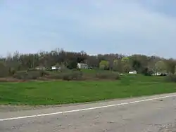 Locust Site (33MU160) |
August 1, 1985 (#85001696) |
On a terrace along the Licking River east of Nashport[9] 40°03′25″N 82°09′22″W |
Licking Township | |
| 37 | Masonic Temple Building | 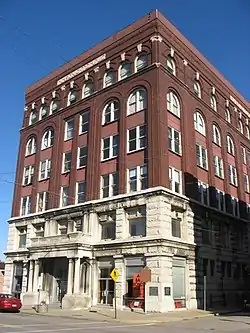 Masonic Temple Building |
May 25, 1990 (#90000756) |
36-42 N. 4th St. 39°56′27″N 82°00′25″W |
Zanesville | |
| 38 | Harry S. McClelland House | 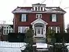 Harry S. McClelland House |
September 27, 1980 (#80003197) |
908 Laurel Ave. 39°57′15″N 82°00′55″W |
Zanesville | |
| 39 | McCully Log House | March 15, 1982 (#82003622) |
North of New Concord on Wharton Lane 40°05′21″N 81°44′55″W |
Monroe Township | ||
| 40 | McIntire Terrace Historic District |  McIntire Terrace Historic District |
September 6, 1979 (#79001918) |
Roughly bounded by Peter Alley, McIntire, Moorehead, Findley, Blue, and Adair Aves. 39°57′03″N 82°00′47″W |
Zanesville | |
| 41 | Mound House |  Mound House |
June 6, 1979 (#79001908) |
400 Mound Rd. 39°52′47″N 81°54′41″W |
Wayne Township | |
| 42 | Mount Zion Presbyterian Church | December 19, 1978 (#78002152) |
Southeast of Chandlersville off State Route 146 39°51′45″N 81°44′59″W |
Rich Hill Township | ||
| 43 | Muskingum College Campus Historic District |  Muskingum College Campus Historic District |
June 11, 1979 (#79001910) |
U.S. Route 22 39°59′47″N 81°44′09″W |
New Concord | |
| 44 | Muskingum County Courthouse and Jail | 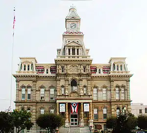 Muskingum County Courthouse and Jail |
July 16, 1973 (#73001515) |
4th and Main Sts. 39°56′26″N 82°00′26″W |
Zanesville | |
| 45 | Muskingum River Lock No. 10 and Canal | 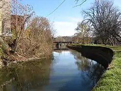 Muskingum River Lock No. 10 and Canal |
December 19, 1978 (#78002165) |
Northern bank of the Muskingum River, north of the railroad bridge south to the lock terminals 39°56′02″N 82°00′11″W |
Zanesville | |
| 46 | Muskingum River Navigation Historic District |  Muskingum River Navigation Historic District |
February 9, 2007 (#07000025) |
Coshocton, Muskingum, Morgan, Washington Counties 40°09′27″N 81°56′41″W |
Numerous jurisdictions | |
| 47 | Nashport Mound | May 24, 1973 (#73001512) |
Along the Licking River below Nashport[10] 40°03′37″N 82°09′57″W |
Licking Township | ||
| 48 | Ohio Power Company |  Ohio Power Company |
November 25, 1980 (#80003198) |
604 Main St. 39°56′24″N 82°00′18″W |
Zanesville | |
| 49 | Paul Hall, Muskingum College |  Paul Hall, Muskingum College |
April 23, 1973 (#73001514) |
Layton Dr., Muskingum College campus 39°59′43″N 81°44′04″W |
New Concord | |
| 50 | Peairs Homestead | February 27, 1979 (#79001919) |
East of Zanesville on State Route 146 39°54′45″N 81°53′44″W |
Salt Creek Township | ||
| 51 | Philo II Archeological District | November 29, 1978 (#78002156) |
Western side of the Muskingum River below Philo[11] 39°48′42″N 81°54′04″W |
Harrison Township | ||
| 52 | Pittsburg, Cincinnati, and St. Louis Depot |  Pittsburg, Cincinnati, and St. Louis Depot |
March 24, 1983 (#83002016) |
Market St. 39°56′34″N 82°00′36″W |
Zanesville | |
| 53 | Prospect Place | 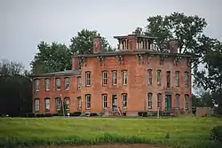 Prospect Place |
May 10, 1979 (#79001913) |
South of Trinway on State Route 60 40°08′05″N 82°00′42″W |
Cass Township | |
| 54 | Putnam Historic District |  Putnam Historic District |
June 30, 1975 (#75001511) |
Bounded by the former Penn Central Railroad tracks, Van Buren St., and the Muskingum River 39°55′55″N 82°00′26″W |
Zanesville | |
| 55 | C.W. Ransbottom House | 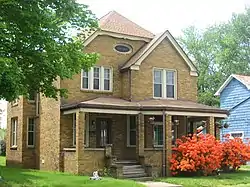 C.W. Ransbottom House |
March 11, 1980 (#80003185) |
291 Washington St. 39°48′35″N 82°04′16″W |
Roseville | |
| 56 | Edward Ransbottom House |  Edward Ransbottom House |
March 11, 1980 (#80003186) |
99 Main St. 39°48′22″N 82°04′22″W |
Roseville | |
| 57 | Frank M. Ransbottom House |  Frank M. Ransbottom House |
March 11, 1980 (#80003187) |
289 Washington St. 39°48′35″N 82°04′16″W |
Roseville | |
| 58 | Mort Ransbottom House |  Mort Ransbottom House |
March 11, 1980 (#80003188) |
152 N. Main St. 39°48′25″N 82°04′20″W |
Roseville | |
| 59 | Adam Rider House |  Adam Rider House |
November 29, 1979 (#79001911) |
9350 Athens Rd., south of Roseville 39°47′43″N 82°03′47″W |
Clay Township | |
| 60 | Roseville High School |  Roseville High School |
March 30, 1978 (#78002157) |
Stokeley and Perry Sts. 39°48′36″N 82°04′24″W |
Roseville | |
| 61 | "S" Bridge II |  "S" Bridge II |
April 23, 1973 (#73001513) |
U.S. Route 40 west of New Concord 39°59′35″N 81°44′48″W |
Union Township | |
| 62 | St. James Episcopal Church |  St. James Episcopal Church |
October 2, 1978 (#78002167) |
155 N. 6th St. 39°56′35″N 82°00′20″W |
Zanesville | |
| 63 | St. John's Evangelical Lutheran Church |  St. John's Evangelical Lutheran Church |
January 3, 1980 (#80003189) |
South of Stovertown on State Route 555 39°49′59″N 81°59′17″W |
Brush Creek Township | |
| 64 | St. John's Lutheran Church | 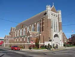 St. John's Lutheran Church |
December 2, 1982 (#82001484) |
Market and N. 7th Sts. 39°56′31″N 82°00′15″W |
Zanesville | |
| 65 | St. Nicholas's Catholic Church |  St. Nicholas's Catholic Church |
September 25, 1975 (#75001512) |
925 Main St. 39°56′24″N 82°00′04″W |
Zanesville | |
| 66 | St. Thomas Aquinas Church | 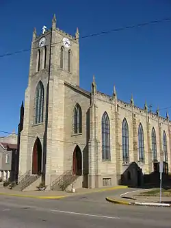 St. Thomas Aquinas Church |
March 11, 1980 (#80003199) |
130 N. 5th St. 39°56′35″N 82°00′24″W |
Zanesville | |
| 67 | Salt Creek Covered Bridge | 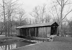 Salt Creek Covered Bridge |
September 10, 1974 (#74001587) |
3 mi (4.8 km) northwest of Norwich 39°59′55″N 81°50′24″W |
Perry Township | |
| 68 | Frederick Augustus Seborn House |  Frederick Augustus Seborn House |
April 4, 1978 (#78002166) |
1115-1119 Maysville Pike 39°55′15″N 82°00′36″W |
Zanesville | |
| 69 | William R. Smith House |  William R. Smith House |
June 1, 1982 (#82003627) |
920 Marietta St. 39°56′10″N 82°00′09″W |
Zanesville | Demolished |
| 70 | David Stormont House |  David Stormont House |
April 21, 1983 (#83002017) |
103 W. Main St. 39°59′37″N 81°44′18″W |
New Concord | |
| 71 | Capt. James Boggs Tannehill House | 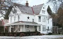 Capt. James Boggs Tannehill House |
August 27, 1979 (#79001921) |
367 Taylor St. 39°58′03″N 82°00′15″W |
Zanesville | |
| 72 | William C. Tanner House | September 17, 1979 (#79001922) |
Northwest of Zanesville 39°59′49″N 82°05′53″W |
Falls Township | ||
| 73 | Tavener-Sears Tavern |  Tavener-Sears Tavern |
April 29, 1982 (#82003621) |
Main St. in Mount Sterling 39°57′25″N 82°09′02″W |
Hopewell Township | |
| 74 | US Post Office and Federal Building-Zanesville | 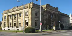 US Post Office and Federal Building-Zanesville |
February 11, 1988 (#88000071) |
65 S. 5th St. 39°56′21″N 82°00′25″W |
Zanesville | Designed by architect George F. Hammond |
| 75 | West Union School | 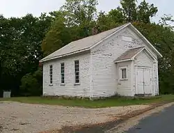 West Union School |
March 30, 1978 (#78002155) |
South of Norwich on County Road 200 39°56′56″N 81°47′59″W |
Union Township | |
| 76 | West View | 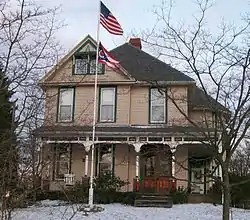 West View |
March 5, 1982 (#82003628) |
444 Sunkel Boulevard 39°57′50″N 82°00′25″W |
Zanesville | |
| 77 | Perry Wiles Grocery Company | 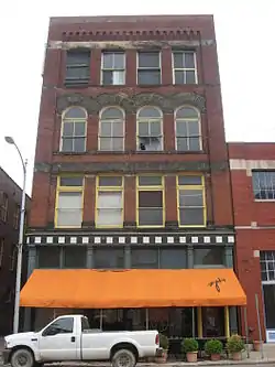 Perry Wiles Grocery Company |
November 25, 1980 (#80003200) |
32-36 N. 3rd St. 39°56′27″N 82°00′32″W |
Zanesville | |
| 78 | Y Bridge |  Y Bridge |
November 2, 1973 (#73001516) |
At the foot of Main St., over the Licking and Muskingum rivers 39°56′25″N 82°00′48″W |
Zanesville | |
| 79 | Zanesville YMCA | 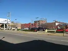 Zanesville YMCA |
October 29, 1985 (#83002018) |
34 S. 5th St. 39°56′20″N 82°00′24″W |
Zanesville | Destroyed |
| 80 | Zanesville YWCA |  Zanesville YWCA |
July 17, 1978 (#78002168) |
49 N. 6th St. 39°56′28″N 82°00′20″W |
Zanesville |
Former listings
| [3] | Name on the Register | Image | Date listed | Date removed | Location | City or town | Summary |
|---|---|---|---|---|---|---|---|
| 1 | Achauer-Linser House and Brewery Complex | August 3, 1978 (#78002158) | October 29, 1985 | 976-988 E. Main Street 39°56′23″N 81°59′54″W |
Zanesville | ||
| 2 | Abram Emery House |  Abram Emery House |
December 6, 1978 (#78002160) | May 12, 2016 | 413 Pershing Rd. 39°55′31″N 82°00′43″W |
Zanesville | Destroyed |
| 3 | Grant School | November 25, 1980 (#80003194) | January 31, 1995 | Off U.S. Route 22 39°55′07″N 82°00′23″W |
Zanesville | ||
| 4 | Lind Arcade |  Lind Arcade |
June 1, 1982 (#82003626) | January 31, 1995 | 48 N. 5th Street 39°56′25″N 82°00′22″W |
Zanesville | |
| 5 | St. Paul's A.M.E. Church and Parsonage | July 17, 1979 (#79001920) | May 7, 1990 | 331 South Street 39°56′19″N 82°00′32″W |
Zanesville |
See also
| Wikimedia Commons has media related to National Register of Historic Places in Muskingum County, Ohio. |
References
- The latitude and longitude information provided in this table was derived originally from the National Register Information System, which has been found to be fairly accurate for about 99% of listings. Some locations in this table may have been corrected to current GPS standards.
- "National Register of Historic Places: Weekly List Actions". National Park Service, United States Department of the Interior. Retrieved on January 29, 2021.
- Numbers represent an alphabetical ordering by significant words. Various colorings, defined here, differentiate National Historic Landmarks and historic districts from other NRHP buildings, structures, sites or objects.
- "National Register Information System". National Register of Historic Places. National Park Service. April 24, 2008.
- The eight-digit number below each date is the number assigned to each location in the National Register Information System database, which can be viewed by clicking the number.
- Goldstein, Ezra. "Losing a Landmark". Ohio Magazine (February 2009). Archived from the original on 4 March 2016. Retrieved 15 October 2015.
- "National Register of Historic Places Registration Form - Howard Chandler Christy Art Studio" (PDF). March 9, 2010. Archived from the original (PDF) on March 15, 2012. Retrieved July 7, 2011.
- Street address derived from this photograph; the NRIS only lists the building on N. 3rd St.
- Location derived from Seeman, Mark F. The Locust Site (33Mu160): The 1983 Test Excavation of a Multicomponent Workshop in East Central Ohio. Kent: Kent State UP, 1985, 3/5. The NRIS lists the site as "Address Restricted".
- Location derived from Mills, William C. Archeological Atlas of Ohio. Columbus: Ohio State Archeological and Historical Society, 1914, page 60 and plate 60. The NRIS lists the site as "Address Restricted"
- Carskadden, Jeff. "Excavation of Mound D at the Philo Mound Group Muskingum County Ohio". Ohio Archaeologist 39.1 (1989): 4-8: 6.

Municipalities and communities of Muskingum County, Ohio, United States | ||
|---|---|---|
| City | Map of Ohio highlighting Muskingum County | |
| Villages | ||
| Townships | ||
| CDPs | ||
| Unincorporated communities |
| |
| Former communities | ||
| Footnotes | ‡This populated place also has portions in an adjacent county or counties | |
| ||
This article is issued from Wikipedia. The text is licensed under Creative Commons - Attribution - Sharealike. Additional terms may apply for the media files.