National Register of Historic Places listings in Knox County, Ohio
This is a list of the National Register of Historic Places listings in Knox County, Ohio.
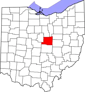
Location of Knox County in Ohio
This is intended to be a complete list of the properties and districts on the National Register of Historic Places in Knox County, Ohio, United States. The locations of National Register properties and districts for which the latitude and longitude coordinates are included below, may be seen in a Google map.[1]
There are 45 properties and districts listed on the National Register in the county.
- This National Park Service list is complete through NPS recent listings posted January 29, 2021.[2]
Current listings
| [3] | Name on the Register[4] | Image | Date listed[5] | Location | City or town | Description |
|---|---|---|---|---|---|---|
| 1 | Samuel Beers House |  Samuel Beers House |
November 6, 1979 (#79003855) |
W. Sandusky St. 40°28′49″N 82°33′08″W |
Fredericktown | |
| 2 | Bell House |  Bell House |
November 6, 1979 (#79003856) |
53-57 N. Main St. 40°28′55″N 82°32′37″W |
Fredericktown | |
| 3 | Brick Commercial Block |  Brick Commercial Block |
November 6, 1979 (#79003857) |
Main and College Sts. 40°28′57″N 82°32′37″W |
Fredericktown | |
| 4 | William Burch House |  William Burch House |
November 6, 1979 (#79003858) |
Edgehill Dr. and Mount Vernon Ave. 40°28′49″N 82°32′26″W |
Fredericktown | |
| 5 | Henry Cassell House |  Henry Cassell House |
November 6, 1979 (#79003859) |
23 High St. 40°29′03″N 82°32′40″W |
Fredericktown | |
| 6 | Christ Church at the Quarry |  Christ Church at the Quarry |
September 25, 1975 (#75001446) |
East of Gambier at the junction of Quarry Chapel and Monroe Mills Rds. 40°23′16″N 82°22′15″W |
College Township | |
| 7 | Wilson S. Cummings House |  Wilson S. Cummings House |
November 6, 1979 (#79003860) |
Sandusky and Taylor Sts. 40°28′53″N 82°32′52″W |
Fredericktown | |
| 8 | Elias Delashment House |  Elias Delashment House |
November 6, 1979 (#79003861) |
2nd St. and Edgehill Dr. 40°28′53″N 82°32′27″W |
Fredericktown | |
| 9 | Downtown Mount Vernon Historic District | 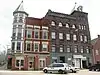 Downtown Mount Vernon Historic District |
February 3, 2012 (#11001092) |
S. Main, S. Mulberry, S. Gay, High, Vine, Gambier, and Howard Sts., Ohio Ave, and Phillips Dr. 40°23′30″N 82°29′08″W |
Mount Vernon | |
| 10 | Early Greek Revival Cottage | 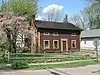 Early Greek Revival Cottage |
November 6, 1979 (#79003862) |
2nd and Chestnut Sts. 40°28′55″N 82°32′41″W |
Fredericktown | |
| 11 | Early Greek Revival House | 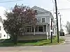 Early Greek Revival House |
November 6, 1979 (#79003863) |
Main and 2nd Sts. 40°28′55″N 82°32′35″W |
Fredericktown | |
| 12 | East Gambier Street District |  East Gambier Street District |
November 18, 1976 (#76001459) |
100-519 E. Gambier St. 40°23′28″N 82°28′48″W |
Mount Vernon | |
| 13 | East High Street Historic District | 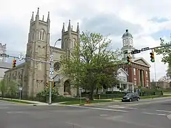 East High Street Historic District |
March 18, 1987 (#86003490) |
Roughly bounded by E. Chestnut St., S. Catherine St., E. Vine St., and S. Gay St. 40°23′35″N 82°28′51″W |
Mount Vernon | |
| 14 | Fredericktown Presbyterian Church | 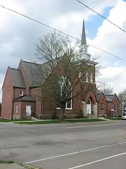 Fredericktown Presbyterian Church |
November 6, 1979 (#79003864) |
Main St. and Public Sq. 40°28′50″N 82°32′37″W |
Fredericktown | |
| 15 | Gambier Historic District |  Gambier Historic District |
May 10, 2000 (#99001686) |
Roughly bounded by State Route 229, Meadow Ln., Brooklyn St., and the northern village boundary 40°22′35″N 82°23′43″W |
Gambier | |
| 16 | Gothic Revival House | 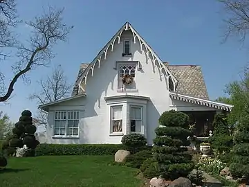 Gothic Revival House |
November 6, 1979 (#79003865) |
High and N. Main Sts. 40°29′01″N 82°32′38″W |
Fredericktown | |
| 17 | Greek Revival Commercial Building | 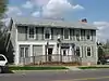 Greek Revival Commercial Building |
November 6, 1979 (#79003866) |
67-69 N. Main St. 40°28′55″N 82°32′37″W |
Fredericktown | |
| 18 | Hosack House |  Hosack House |
November 6, 1979 (#79003867) |
W. College St. 40°28′56″N 82°32′38″W |
Fredericktown | |
| 19 | Kenyon College | 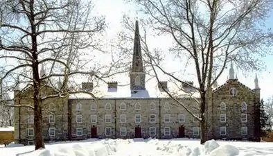 Kenyon College |
December 6, 1975 (#75001447) |
State Routes 229 and 308 40°22′29″N 82°23′50″W |
Gambier | |
| 20 | Dr. King House | 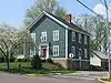 Dr. King House |
November 6, 1979 (#79003868) |
Main and 2nd Sts. 40°28′54″N 82°32′37″W |
Fredericktown | |
| 21 | Knox County Courthouse | .jpg.webp) Knox County Courthouse |
June 4, 1973 (#73001484) |
High St. 40°23′37″N 82°28′57″W |
Mount Vernon | |
| 22 | Knox County Infirmary | 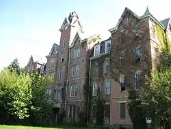 Knox County Infirmary |
July 10, 1986 (#86001567) |
7516 Johnstown Rd., southwest of Mount Vernon 40°20′52″N 82°33′07″W |
Liberty Township | Destroyed in a fire on June 26, 2015.[6] |
| 23 | Kokosing House | 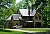 Kokosing House |
February 19, 1985 (#85000450) |
221 Kokosing Dr. 40°22′43″N 82°24′12″W |
Gambier | |
| 24 | Richard and Ann Loveridge House | 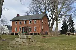 Richard and Ann Loveridge House |
April 1, 2009 (#09000171) |
12526 Lower Green Valley Rd., northwest of Mount Vernon 40°25′11″N 82°31′34″W |
Morris Township | |
| 25 | James McFarland House |  James McFarland House |
March 9, 1990 (#90000384) |
7864 Newark Rd., south of Mount Vernon 40°20′58″N 82°28′18″W |
Clinton Township | |
| 26 | McKee-Pumphrey House |  McKee-Pumphrey House |
July 28, 1995 (#95000938) |
165 N. Market St. 40°16′19″N 82°21′14″W |
Martinsburg | |
| 27 | McLaughlin Mound | December 11, 1972 (#72001025) |
Address Restricted |
Mount Vernon | ||
| 28 | Mill Road Bowstring Bridge | 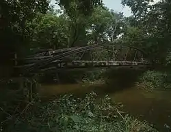 Mill Road Bowstring Bridge |
December 5, 1979 (#79001869) |
Ariel-Foundation Park[7] 40°23′16″N 82°29′55″W |
Mount Vernon | Formerly located on Mill Road east of Bladensburg |
| 29 | Mount Liberty Tavern | 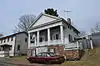 Mount Liberty Tavern |
May 3, 1974 (#74001539) |
U.S. Route 36 in Mount Liberty 40°20′46″N 82°37′54″W |
Liberty Township | |
| 30 | North Main-North Gay Streets Historic District |  North Main-North Gay Streets Historic District |
March 9, 1990 (#90000383) |
Roughly bounded by Curtis St., N. Gay St., Public Sq., and N. Main St. 40°23′50″N 82°29′05″W |
Mount Vernon | |
| 31 | Old Davis and Dague Grocery Store |  Old Davis and Dague Grocery Store |
November 6, 1979 (#79003869) |
Main and College Sts. 40°28′57″N 82°32′35″W |
Fredericktown | |
| 32 | Old Greek Revival Farmhouse |  Old Greek Revival Farmhouse |
November 6, 1979 (#79003870) |
W. Sandusky St. 40°28′50″N 82°32′59″W |
Fredericktown | Destroyed |
| 33 | Old Methodist Church |  Old Methodist Church |
November 6, 1979 (#79003871) |
Sandusky St. and Public Sq. 40°28′51″N 82°32′34″W |
Fredericktown | |
| 34 | Old Telephone Building |  Old Telephone Building |
November 6, 1979 (#79003872) |
College and Chestnut Sts. 40°28′57″N 82°32′39″W |
Fredericktown | |
| 35 | Pennsylvania Depot |  Pennsylvania Depot |
November 3, 1972 (#09000100) |
S. Main St. 40°23′19″N 82°29′12″W |
Mount Vernon | |
| 36 | Raleigh Mound | 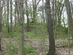 Raleigh Mound |
October 14, 1975 (#75001445) |
Mound St.[8] 40°28′25″N 82°32′35″W |
Fredericktown | Also known as the "Rowley Mound"[8] |
| 37 | James Reed House | 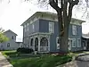 James Reed House |
November 6, 1979 (#79003873) |
E. College St. 40°28′57″N 82°32′30″W |
Fredericktown | |
| 38 | Round Hill | 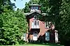 Round Hill |
December 12, 1976 (#76001460) |
E. Pleasant and N. McKenzie Sts. 40°23′56″N 82°28′48″W |
Mount Vernon | |
| 39 | Second Hosack House |  Second Hosack House |
November 6, 1979 (#79003874) |
College and Chestnut Sts. 40°28′56″N 82°32′39″W |
Fredericktown | |
| 40 | Sprague-Deaver House | 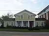 Sprague-Deaver House |
November 6, 1979 (#79003875) |
Sandusky and Pleasant Sts. 40°28′51″N 82°32′33″W |
Fredericktown | |
| 41 | Stackhouse Mound and Works |  Stackhouse Mound and Works |
June 18, 1973 (#73001483) |
Off Montgomery Road east of Fredericktown[9] 40°28′51″N 82°31′46″W |
Morris Township | Originally listed as "Braddock Mound and Works"[10] |
| 42 | Enoch Thompson House |  Enoch Thompson House |
November 25, 1980 (#80003107) |
South of Mount Vernon on State Route 661 40°16′08″N 82°30′59″W |
Miller Township | |
| 43 | Tuttle House |  Tuttle House |
July 12, 1976 (#76001458) |
33 E. College St. 40°28′57″N 82°32′31″W |
Fredericktown | |
| 44 | Woodward Opera House |  Woodward Opera House |
October 10, 1975 (#75001448) |
Main and Vine Sts. 40°23′33″N 82°29′10″W |
Mount Vernon | |
| 45 | Lyman Wright Building |  Lyman Wright Building |
November 6, 1979 (#79003876) |
Main and 2nd Sts. 40°28′54″N 82°32′35″W |
Fredericktown |
See also
| Wikimedia Commons has media related to National Register of Historic Places in Knox County, Ohio. |
References
- The latitude and longitude information provided in this table was derived originally from the National Register Information System, which has been found to be fairly accurate for about 99% of listings. Some locations in this table may have been corrected to current GPS standards.
- "National Register of Historic Places: Weekly List Actions". National Park Service, United States Department of the Interior. Retrieved on January 29, 2021.
- Numbers represent an alphabetical ordering by significant words. Various colorings, defined here, differentiate National Historic Landmarks and historic districts from other NRHP buildings, structures, sites or objects.
- "National Register Information System". National Register of Historic Places. National Park Service. April 24, 2008.
- The eight-digit number below each date is the number assigned to each location in the National Register Information System database, which can be viewed by clicking the number.
- Main, Fred (26 June 2015). "Eight departments responded to former Bible College blaze". Mount Vernon News. Mount Vernon, Ohio. Archived from the original on 27 June 2015. Retrieved 26 June 2015.
- Martin, Chuck (3 July 2014). "Ariel-Foundation Park bridge and pavilion open for business". Mount Vernon News. Mount Vernon, Ohio. Archived from the original on 29 June 2015. Retrieved 26 June 2015.
- Location derived from its GNIS feature record; the NRIS lists the site as "Address Restricted".
- Location derived from the GNIS feature record for the Braddock Mound; the NRIS lists the site as "Address Restricted".
- Derived from its Federal Register notice; no other properties in Knox County were listed on that date

Municipalities and communities of Knox County, Ohio, United States | ||
|---|---|---|
| City | Map of Ohio highlighting Knox County | |
| Villages | ||
| Townships | ||
| CDPs | ||
| Unincorporated communities | ||
| Ghost town | ||
| Footnotes | ‡This populated place also has portions in an adjacent county or counties | |
| ||
This article is issued from Wikipedia. The text is licensed under Creative Commons - Attribution - Sharealike. Additional terms may apply for the media files.