National Register of Historic Places listings in Marion County, Ohio
This is a list of the National Register of Historic Places listings in Marion County, Ohio.
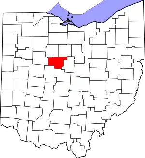
Location of Marion County in Ohio
This is intended to be a complete list of the properties and districts on the National Register of Historic Places in Marion County, Ohio, United States. The locations of National Register properties and districts for which the latitude and longitude coordinates are included below, may be seen in an online map.[1]
There are 16 properties and districts listed on the National Register in the county, including 1 National Historic Landmark.
- This National Park Service list is complete through NPS recent listings posted January 29, 2021.[2]
Current listings
| [3] | Name on the Register[4] | Image | Date listed[5] | Location | City or town | Description |
|---|---|---|---|---|---|---|
| 1 | Bretz Farm | 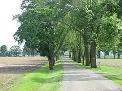 Bretz Farm |
January 8, 1980 (#80003155) |
197 Morral-Kirkpatrick Rd., east of Morral 40°41′16″N 83°09′20″W |
Grand Prairie Township | |
| 2 | Caledonia Bowstring Bridge |  Caledonia Bowstring Bridge |
May 23, 1978 (#78002131) |
North of Caledonia 40°38′33″N 82°57′55″W |
Claridon Township | |
| 3 | Harding Tomb |  Harding Tomb |
June 16, 1976 (#76001485) |
Marion Cemetery 40°34′23″N 83°07′23″W |
Marion | |
| 4 | Warren G. Harding House | 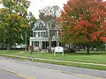 Warren G. Harding House |
October 15, 1966 (#66000618) |
380 Mount Vernon Ave. 40°35′11″N 83°07′19″W |
Marion | |
| 5 | Hotel Harding |  Hotel Harding |
March 11, 1980 (#80003154) |
267 W. Center St. 40°35′17″N 83°08′00″W |
Marion | |
| 6 | George W. King Mansion-Etowah |  George W. King Mansion-Etowah |
November 22, 1995 (#95001331) |
429 Mount Vernon Ave. 40°35′06″N 83°07′14″W |
Marion | |
| 7 | Marion Catholic School | Marion Catholic School |
September 11, 2017 (#100001587) |
1001 and 1047 Mount Vernon Ave. and 590 Forest Lawn Dr. 40°34′48″N 83°06′18″W |
Marion | |
| 8 | Marion Cemetery Receiving Vault |  Marion Cemetery Receiving Vault |
December 13, 1995 (#95001415) |
620 Delaware Ave. 40°34′34″N 83°07′20″W |
Marion | |
| 9 | Marion County Courthouse |  Marion County Courthouse |
July 25, 1974 (#74001572) |
100 N. Main St.[6] 40°35′20″N 83°07′42″W |
Marion | |
| 10 | Marion County Telephone Company Building |  Marion County Telephone Company Building |
April 12, 2007 (#07000298) |
197 S. Main St. 40°35′12″N 83°07′45″W |
Marion | |
| 11 | Marion Township Sub-District No. 8 School | 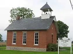 Marion Township Sub-District No. 8 School |
February 7, 2007 (#07000027) |
2473 State Route 4 N., north of Marion 40°38′13″N 83°07′35″W |
Marion Township | |
| 12 | Marion Women's Club Home | 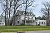 Marion Women's Club Home |
December 23, 2019 (#100004781) |
1126 E. Center St. 40°35′25″N 83°06′04″W |
Marion | |
| 13 | Old US Post Office | 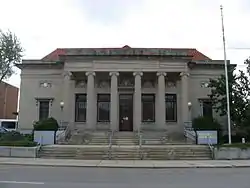 Old US Post Office |
November 28, 1990 (#90001777) |
169 E. Church St. 40°35′14″N 83°07′32″W |
Marion | |
| 14 | Palace Theatre |  Palace Theatre |
March 26, 1976 (#76001486) |
272 W. Center St. 40°35′19″N 83°08′01″W |
Marion | |
| 15 | Soldiers' and Sailors' Memorial Chapel |  Soldiers' and Sailors' Memorial Chapel |
March 9, 1995 (#95000169) |
Eastern side of State Route 423 within Marion Cemetery 40°34′40″N 83°07′28″W |
Marion | |
| 16 | Wyatt's Tavern-Fort Morrow Site |  Wyatt's Tavern-Fort Morrow Site |
December 22, 1978 (#78002132) |
Along the Olentangy River, 1 mile (1.6 km) north of Norton[7] 40°26′39″N 83°04′15″W |
Waldo Township |
See also
| Wikimedia Commons has media related to National Register of Historic Places in Marion County, Ohio. |
References
- The latitude and longitude information provided in this table was derived originally from the National Register Information System, which has been found to be fairly accurate for about 99% of listings. Some locations in this table may have been corrected to current GPS standards.
- "National Register of Historic Places: Weekly List Actions". National Park Service, United States Department of the Interior. Retrieved on January 29, 2021.
- Numbers represent an alphabetical ordering by significant words. Various colorings, defined here, differentiate National Historic Landmarks and historic districts from other NRHP buildings, structures, sites or objects.
- "National Register Information System". National Register of Historic Places. National Park Service. March 13, 2009.
- The eight-digit number below each date is the number assigned to each location in the National Register Information System database, which can be viewed by clicking the number.
- Address derived from this Archived 2009-10-03 at the Wayback Machine Marion County webpage; the NRIS lists the courthouse on "Courthouse Square"
- Location derived from this county history; coordinates derived from the location of the Wyatt family cemetery on USGS topographical maps. The NRIS lists the site as "Address Restricted".

Municipalities and communities of Marion County, Ohio, United States | ||
|---|---|---|
| City | Map of Ohio highlighting Marion County | |
| Villages | ||
| Townships | ||
| Unincorporated communities | ||
| Ghost town | ||
| ||
This article is issued from Wikipedia. The text is licensed under Creative Commons - Attribution - Sharealike. Additional terms may apply for the media files.