National Register of Historic Places listings in Union County, Ohio
This is a list of the National Register of Historic Places listings in Union County, Ohio.
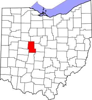
Location of Union County in Ohio
It is intended to be a complete list of the properties and districts on the National Register of Historic Places in Union County, Ohio, United States. The locations of National Register properties and districts for which the latitude and longitude coordinates are included below, may be seen in a Google map.[1]
There are 7 properties and districts listed on the National Register in the county.
- This National Park Service list is complete through NPS recent listings posted January 29, 2021.[2]
Current listings
| [3] | Name on the Register[4] | Image | Date listed[5] | Location | City or town | Description |
|---|---|---|---|---|---|---|
| 1 | Ellis Mounds | 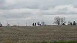 Ellis Mounds |
July 30, 1974 (#74001638) |
Within the triangle formed by Hillview Rd., Wolford-Maskill Rd., and State Route 4, northeast of Marysville[6] 40°17′15″N 83°20′56″W |
Paris Township | |
| 2 | Elmwood Place | 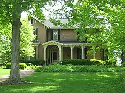 Elmwood Place |
November 29, 1979 (#79001972) |
Southwest of Irwin on State Route 161 40°07′09″N 83°29′03″W |
Union Township | |
| 3 | The Fort | 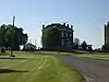 The Fort |
July 8, 1982 (#82003662) |
26953 North Lewisburg Rd., northeast of North Lewisburg 40°13′55″N 83°33′01″W |
Allen Township | |
| 4 | Gilcrist House |  Gilcrist House |
August 13, 1976 (#76001537) |
3.5 miles southeast of downtown Marysville off U.S. Route 33 40°12′30″N 83°18′53″W |
Marysville | Destroyed[7] |
| 5 | Dr. David W. Henderson House | 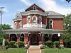 Dr. David W. Henderson House |
April 19, 2001 (#01000391) |
318 E. 5th St. 40°14′11″N 83°21′49″W |
Marysville | |
| 6 | Marysville Historic District | 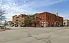 Marysville Historic District |
February 1, 1978 (#78002201) |
Roughly bounded by Maple, Plum, 4th, and 7th Sts. 40°14′08″N 83°22′06″W |
Marysville | |
| 7 | Reed Covered Bridge | 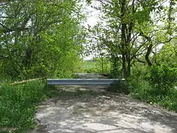 Reed Covered Bridge |
March 4, 1975 (#75001547) |
3.5 miles south of Marysville off State Route 38 40°08′59″N 83°22′50″W |
Darby Township | 150-feet long Partridge truss bridge. Collapsed in 1993 |
See also
| Wikimedia Commons has media related to National Register of Historic Places in Union County, Ohio. |
References
- The latitude and longitude information provided in this table was derived originally from the National Register Information System, which has been found to be fairly accurate for about 99% of listings. Some locations in this table may have been corrected to current GPS standards.
- "National Register of Historic Places: Weekly List Actions". National Park Service, United States Department of the Interior. Retrieved on January 29, 2021.
- Numbers represent an alphabetical ordering by significant words. Various colorings, defined here, differentiate National Historic Landmarks and historic districts from other NRHP buildings, structures, sites or objects.
- "National Register Information System". National Register of Historic Places. National Park Service. April 24, 2008.
- The eight-digit number below each date is the number assigned to each location in the National Register Information System database, which can be viewed by clicking the number.
- Owen, Lorrie K., ed. Dictionary of Ohio Historic Places. Vol. 12 St. Clair Shores: Somerset, 1999, 1362.
- Gilchrist House, Ohio Historical Society, 2007. Accessed 2010-05-10.

Municipalities and communities of Union County, Ohio, United States | ||
|---|---|---|
| Cities | Map of Ohio highlighting Union County | |
| Villages | ||
| Townships | ||
| CDPs | ||
| Unincorporated communities | ||
| Ghost town | ||
| Footnotes | ‡This populated place also has portions in an adjacent county or counties | |
| ||
This article is issued from Wikipedia. The text is licensed under Creative Commons - Attribution - Sharealike. Additional terms may apply for the media files.