National Register of Historic Places listings in Greene County, Ohio
This is a list of the National Register of Historic Places listings in Greene County, Ohio.
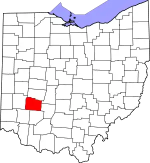
Location of Greene County in Ohio
This is intended to be a complete list of the properties and districts on the National Register of Historic Places in Greene County, Ohio, United States. The locations of National Register properties and districts for which the latitude and longitude coordinates are included below, may be seen in an online map.[1]
There are 44 properties and districts listed on the National Register in the county, including 2 National Historic Landmarks. Another 2 properties were once listed but have been removed.
- This National Park Service list is complete through NPS recent listings posted January 29, 2021.[2]
Current listings
| [3] | Name on the Register[4] | Image | Date listed[5] | Location | City or town | Description |
|---|---|---|---|---|---|---|
| 1 | Antioch Hall, North and South Halls | 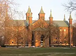 Antioch Hall, North and South Halls |
June 30, 1975 (#75001411) |
Along Hyde Rd. on the Antioch College campus 39°47′59″N 83°53′17″W |
Yellow Springs | |
| 2 | Ballard Road Covered Bridge | 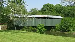 Ballard Road Covered Bridge |
May 29, 1975 (#75001408) |
Northwest of Jamestown on Ballard Rd. over Caesars Creek 39°40′41″N 83°48′55″W |
New Jasper Township | 1880s covered bridge, no longer open to through traffic |
| 3 | Bank of Xenia | 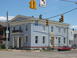 Bank of Xenia |
May 7, 1973 (#73001450) |
Northeastern corner of Detroit and E. 2nd Sts. 39°41′02″N 83°55′44″W |
Xenia | Greek Revival bank near downtown Xenia |
| 4 | George Barrett Concrete House |  George Barrett Concrete House |
April 10, 1986 (#86000699) |
4 E. Main St. 39°36′32″N 84°00′30″W |
Spring Valley | |
| 5 | Bath Township Consolidated School |  Bath Township Consolidated School |
September 22, 1983 (#83001974) |
221 N. Central Ave. 39°49′32″N 84°01′17″W |
Fairborn | |
| 6 | Berryhill-Morris House | 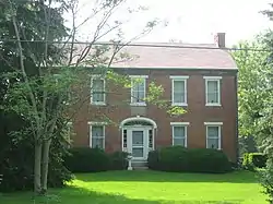 Berryhill-Morris House |
November 12, 1975 (#75001407) |
South of Bellbrook at 3113 Ferry Rd. 39°36′15″N 84°05′14″W |
Sugarcreek Township | Home of one of the township's first resident families |
| 7 | Brick Quarters Historic District | November 5, 2018 (#100003071) |
Chidlaw Rd. and Metzger Dr. at Wright-Patterson Air Force Base 39°48′32″N 84°02′20″W |
Bath Township | ||
| 8 | C.N. & I. Department Power House | 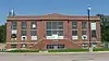 C.N. & I. Department Power House |
October 30, 2003 (#03001099) |
Central State University campus in Wilberforce 39°43′01″N 83°52′29″W |
Xenia Township | |
| 9 | Carnegie Library (Old Wilberforce University Campus) | 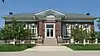 Carnegie Library (Old Wilberforce University Campus) |
June 16, 2004 (#04000610) |
1400 Brush Row Rd. in Wilberforce 39°43′03″N 83°52′55″W |
Xenia Township | |
| 10 | Cedarville Opera House | 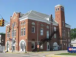 Cedarville Opera House |
February 9, 1984 (#84003697) |
78 N. Main St. 39°44′30″N 83°48′25″W |
Cedarville | Community center and performance hall |
| 11 | Alexander Conner House | 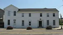 Alexander Conner House |
July 28, 1987 (#87000460) |
99 E. 2nd St. 39°41′02″N 83°55′42″W |
Xenia | Six early buildings joined into a rowhouse |
| 12 | Dean Family Farm |  Dean Family Farm |
May 29, 1975 (#75001409) |
5 mi (8.0 km) northwest of Jamestown off U.S. Route 35 on Ballard Rd.; also 199 S. Ballard Rd. 39°40′34″N 83°49′07″W |
New Jasper Township | 1820s farmstead. 199 Ballard represents a boundary increase of November 16, 1994, the Dean Family Farm Historic District. |
| 13 | Downtown Xenia Historic District | 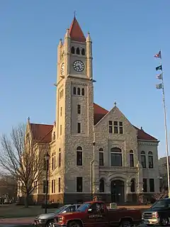 Downtown Xenia Historic District |
September 10, 2014 (#14000590) |
Bounded by Church, Galloway, 3rd, and Collier Sts. 39°41′08″N 83°55′45″W |
Xenia | |
| 14 | East Second Street District | 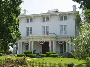 East Second Street District |
March 20, 1973 (#73001451) |
235 and 209-213-215 E. 2nd St.; also 184-271 E. 2nd St. 39°41′01″N 83°55′31″W |
Xenia | Prestigious Gilded Age neighborhood. Second set of boundaries represents a boundary increase of September 10, 1979 |
| 15 | Emery Hall | 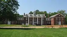 Emery Hall |
October 4, 2005 (#05001144) |
Central State University campus in Wilberforce 39°43′03″N 83°52′58″W |
Xenia Township | |
| 16 | Fairborn Theatre | 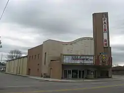 Fairborn Theatre |
July 27, 2005 (#05000755) |
34 S. Broad St. 39°49′14″N 84°01′39″W |
Fairborn | Streamline Moderne theater, built with themes relevant to the nearby military base |
| 17 | Grinnell Mill Historic District |  Grinnell Mill Historic District |
November 29, 1982 (#82001464) |
3536 Bryan Park Rd., southeast of Yellow Springs 39°46′59″N 83°52′28″W |
Miami Township | |
| 18 | Harper Mausoleum and George W. Harper Memorial Entrance | 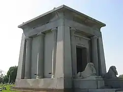 Harper Mausoleum and George W. Harper Memorial Entrance |
February 11, 1988 (#88000115) |
North Cemetery along State Route 72 39°45′15″N 83°48′44″W |
Cedarville | Egyptian Revival memorial to a wealthy Cedarville resident |
| 19 | Hollencamp House |  Hollencamp House |
July 18, 1980 (#80003029) |
339 E. 2nd St. 39°41′03″N 83°55′24″W |
Xenia | Home of a leading immigrant brewer |
| 20 | Huffman Field |  Huffman Field |
May 6, 1971 (#71000640) |
Wright-Patterson Air Force Base, 1 mi (1.6 km) southwest of Fairborn 39°48′12″N 84°03′57″W |
Bath Township | Field where the Wright brothers learned to fly |
| 21 | Jamestown Opera House | 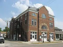 Jamestown Opera House |
October 17, 2007 (#07001093) |
19 N. Limestone St. 39°39′32″N 83°44′04″W |
Jamestown | Community center and government building |
| 22 | Main Street Historic District |  Main Street Historic District |
May 19, 1989 (#89000431) |
Roughly E. and W. Main St. from Elm to Water Sts. 39°36′33″N 84°00′28″W |
Spring Valley | |
| 23 | McDonald Farm | 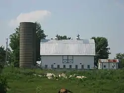 McDonald Farm |
June 14, 1996 (#96000673) |
1446 Stone Rd., southeast of Xenia 39°38′28″N 83°53′00″W |
Xenia Township | Source of stone for the Washington Monument |
| 24 | Mercer Log House | 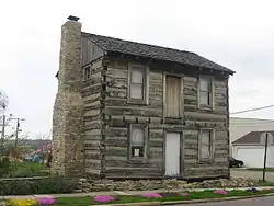 Mercer Log House |
October 16, 1981 (#81000433) |
41 N. 1st St. 39°49′25″N 84°01′44″W |
Fairborn | One of Ohio's best-preserved log cabins from the territorial period |
| 25 | Millen-Schmidt House |  Millen-Schmidt House |
November 7, 1976 (#76001432) |
184 N. King St. 39°41′14″N 83°55′54″W |
Xenia | Italianate mansion, built to be "a house that people will notice" |
| 26 | Old Chillicothe Site |  Old Chillicothe Site |
April 21, 1975 (#75001410) |
Along U.S. Route 68 north of Xenia[6][7] 39°43′49″N 83°56′16″W |
Xenia Township | |
| 27 | The Old Hotel |  The Old Hotel |
August 25, 1988 (#88001296) |
100-101½ W. Main St. 39°36′30″N 84°00′34″W |
Spring Valley | |
| 28 | Orators Mound | 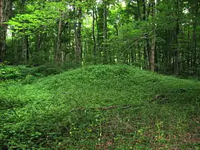 Orators Mound |
July 15, 1974 (#74001507) |
Near Yellow Spring, east of the village of Yellow Springs[8] 39°48′16″N 83°52′55″W |
Miami Township | Indian mound in Glen Helen; named for its common use as a speaker's platform |
| 29 | Samuel N. Patterson House | 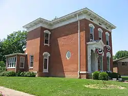 Samuel N. Patterson House |
June 3, 1976 (#76001433) |
364 N. King St. 39°41′23″N 83°55′56″W |
Xenia | 1870s house; one of its neighborhood's few survivors of the 1974 tornado |
| 30 | Pollock Works | 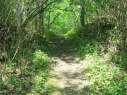 Pollock Works |
February 23, 1972 (#72001014) |
Along Massie's Creek, west of Cedarville[6] 39°44′23″N 83°49′24″W |
Cedarville Township | Hopewellian ceremonial site on a hilltop |
| 31 | Whitelaw Reid House |  Whitelaw Reid House |
May 7, 1973 (#73001448) |
Northwest of Cedarville at 2587 Conley Rd. 39°45′06″N 83°50′10″W |
Cedarville Township | Home of Whitelaw Reid, journalist and politician |
| 32 | South School |  South School |
October 4, 1989 (#89001459) |
909 S. High St. 39°47′55″N 83°53′45″W |
Yellow Springs | 1850s Greek Revival school; formerly Yellow Springs High School |
| 33 | Tawawa Chimney Corner | July 27, 2020 (#100005361) |
1198 Brush Row Rd. 39°43′08″N 83°53′11″W |
Wilberforce | ||
| 34 | Waterstreet Historic District |  Waterstreet Historic District |
August 11, 1980 (#80003030) |
Roughly bounded by Shawnee Creek and S. Detroit, S. Church and W. 2nd Sts. 39°40′58″N 83°55′54″W |
Xenia | |
| 35 | Whitehall Farm | 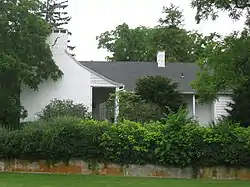 Whitehall Farm |
July 31, 1980 (#80003031) |
North of Yellow Springs off U.S. Route 68 39°48′42″N 83°52′55″W |
Miami Township | Greek Revival country estate |
| 36 | Benjamin Whiteman House |  Benjamin Whiteman House |
April 3, 1973 (#73001449) |
East of Clifton 39°47′45″N 83°49′01″W |
Cedarville Township | |
| 37 | Wickersham House | December 7, 2018 (#100003208) |
23 E. Washington St. 39°39′29″N 83°44′00″W |
Jamestown | ||
| 38 | Williamson Mound State Memorial | 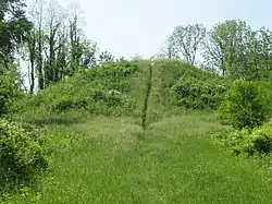 Williamson Mound State Memorial |
December 13, 1971 (#71000639) |
Off U.S. Route 42, west of Cedarville 39°44′42″N 83°49′37″W |
Cedarville Township | Large Adena burial mound |
| 39 | Wright Brothers Hill-Memorial | 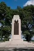 Wright Brothers Hill-Memorial |
July 19, 2016 (#16000460) |
Memorial Dr. 39°47′38″N 84°05′21″W |
Bath Township | |
| 40 | Wright Brothers Memorial Mound Group |  Wright Brothers Memorial Mound Group |
February 12, 1974 (#74001505) |
A short distance west of the Wright Brothers Memorial, west of Fairborn[9] 39°47′41″N 84°05′27″W |
Bath Township | |
| 41 | Wright-Patterson Air Force Base Mound |  Wright-Patterson Air Force Base Mound |
February 23, 1972 (#72001015) |
Located along P St., about 1 kilometre (3,300 ft) south of the Wright Brothers Memorial, west of Fairborn[9] 39°47′12″N 84°05′04″W |
Bath Township | Adena mound on a military base |
| 42 | Xenia Carnegie Library |  Xenia Carnegie Library |
February 24, 2015 (#15000041) |
194 E. Church St. 39°41′16″N 83°55′35″W |
Xenia | |
| 43 | Yellow Springs Historic District | 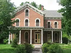 Yellow Springs Historic District |
April 1, 1982 (#82003573) |
Roughly bounded by railroad tracks, Yellow Springs-Fairfield Rd., and High and Herman Sts. 39°48′10″N 83°53′22″W |
Yellow Springs | Large historic district, primarily built during the mid-19th century |
| 44 | Col. Charles Young House | 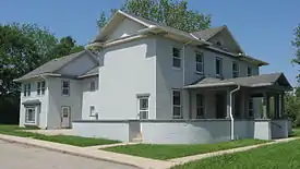 Col. Charles Young House |
March 30, 1974 (#74001506) |
Columbus Pike between Clifton and Stevenson Rds., east of Xenia 39°42′26″N 83°53′25″W |
Xenia Township | House museum open to visitors |
Former listings
| [3] | Name on the Register | Image | Date listed | Date removed | Location | City or town | Summary |
|---|---|---|---|---|---|---|---|
| 1 | Homewood Cottage | Unavailable (#73002286) | 1974 | Brush Row Rd. in Wilberforce |
Xenia Township | Home of Hallie Quinn Brown. Destroyed by a tornado during the April 3–4, 1974 Super Outbreak[10] | |
| 2 | William S. Scarborough House |  William S. Scarborough House |
Unavailable (#73002291) | 1974 | Brush Row Rd. in Wilberforce |
Xenia Township | Home of William Sanders Scarborough. Destroyed by a tornado during the April 4, 1974 Super Outbreak[11] |
See also
| Wikimedia Commons has media related to National Register of Historic Places in Greene County, Ohio. |
References
- The latitude and longitude information provided in this table was derived originally from the National Register Information System, which has been found to be fairly accurate for about 99% of listings. Some locations in this table may have been corrected to current GPS standards.
- "National Register of Historic Places: Weekly List Actions". National Park Service, United States Department of the Interior. Retrieved on January 29, 2021.
- Numbers represent an alphabetical ordering by significant words. Various colorings, defined here, differentiate National Historic Landmarks and historic districts from other NRHP buildings, structures, sites or objects.
- "National Register Information System". National Register of Historic Places. National Park Service. April 24, 2008.
- The eight-digit number below each date is the number assigned to each location in the National Register Information System database, which can be viewed by clicking the number.
- Location derived from Mills, William C. Archeological Atlas of Ohio. Columbus: Ohio State Archeological and Historical Society, 1914, page 29 and plate 29. The NRIS lists the site as "Address Restricted".
- Coordinates derived from its GNIS feature record
- Location derived from Dills, R.S. History of Greene County, Ohio: Together with Historic Notes on the Northwest, and the State of Ohio. Dayton: Odell and Mayer, 1881, 673. The NRIS lists the site as "Address Restricted".
- Location derived from this North American Database of Archaeological Geophysics website; the NRIS lists the site as "Address Restricted"
- Central State University
- Central State University

Municipalities and communities of Greene County, Ohio, United States | ||
|---|---|---|
| Cities | Map of Ohio highlighting Greene County | |
| Villages | ||
| Townships | ||
| CDPs | ||
| Unincorporated communities | ||
| Footnotes | ‡This populated place also has portions in an adjacent county or counties | |
| ||
This article is issued from Wikipedia. The text is licensed under Creative Commons - Attribution - Sharealike. Additional terms may apply for the media files.