National Register of Historic Places listings in Vinton County, Ohio
This is a list of the National Register of Historic Places listings in Vinton County, Ohio.
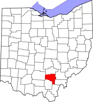
Location of Vinton County in Ohio
This is intended to be a complete list of the properties on the National Register of Historic Places in Vinton County, Ohio, United States. The locations of National Register properties for which the latitude and longitude coordinates are included below, may be seen in a Google map.[1]
There are 10 properties listed on the National Register in the county.
- This National Park Service list is complete through NPS recent listings posted January 29, 2021.[2]
Current listings
| [3] | Name on the Register[4] | Image | Date listed[5] | Location | City or town | Description |
|---|---|---|---|---|---|---|
| 1 | Eakin Mill Covered Bridge | 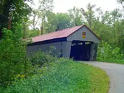 Eakin Mill Covered Bridge |
March 16, 1976 (#76001539) |
Mound Hill Rd. north of Arbaugh 39°10′16″N 82°20′13″W |
Vinton Township | |
| 2 | Hope Furnace | 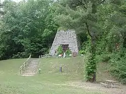 Hope Furnace |
May 25, 1973 (#73001546) |
5 miles northeast of Zaleski on State Route 278 39°19′55″N 82°20′25″W |
Brown Township | |
| 3 | Markham Mound | May 3, 1974 (#74001640) |
Address Restricted |
Zaleski | ||
| 4 | Masonic Lodge No. 472 | 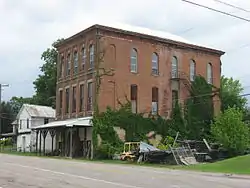 Masonic Lodge No. 472 |
March 9, 2000 (#00000182) |
18 Commercial St. 39°16′56″N 82°23′37″W |
Zaleski | |
| 5 | Mt. Olive Road Covered Bridge | 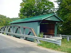 Mt. Olive Road Covered Bridge |
October 8, 1976 (#76001538) |
1 mile northeast of Allensville on Mt. Olive Rd. 39°17′10″N 82°35′21″W |
Jackson Township | |
| 6 | Ponn Humpback Covered Bridge | 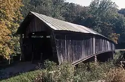 Ponn Humpback Covered Bridge |
April 11, 1973 (#73001545) |
4 miles southwest of Wilkesville over Raccoon Creek 39°02′52″N 82°22′35″W |
Wilkesville Township | Built in 1874 to replace an arsoned structure; arsoned in 2013[6] |
| 7 | Ranger Station Mound |  Ranger Station Mound |
July 15, 1974 (#74001641) |
Entrance to Zaleski State Forest[7] 39°17′14″N 82°23′42″W |
Zaleski | |
| 8 | Ratcliffe Mound | 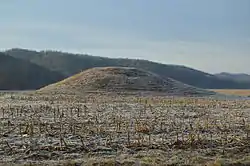 Ratcliffe Mound |
August 28, 1975 (#75001548) |
5 miles northeast of Londonderry on State Route 327[8] 39°18′27″N 82°43′32″W |
Eagle Township | |
| 9 | Trinity Episcopal Church | 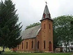 Trinity Episcopal Church |
March 16, 1976 (#76001540) |
Sugar and High Sts. 39°14′51″N 82°28′49″W |
McArthur | |
| 10 | Zaleski Methodist Church Mound |  Zaleski Methodist Church Mound |
July 15, 1974 (#74001642) |
114 Broadway St.[9] 39°17′02″N 82°23′44″W |
Zaleski |
See also
| Wikimedia Commons has media related to National Register of Historic Places in Vinton County, Ohio. |
References
- The latitude and longitude information provided in this table was derived originally from the National Register Information System, which has been found to be fairly accurate for about 99% of listings. Some locations in this table may have been corrected to current GPS standards.
- "National Register of Historic Places: Weekly List Actions". National Park Service, United States Department of the Interior. Retrieved on January 29, 2021.
- Numbers represent an alphabetical ordering by significant words. Various colorings, defined here, differentiate National Historic Landmarks and historic districts from other NRHP buildings, structures, sites or objects.
- "National Register Information System". National Register of Historic Places. National Park Service. April 24, 2008.
- The eight-digit number below each date is the number assigned to each location in the National Register Information System database, which can be viewed by clicking the number.
- Investigators Still Looking for Answers in Humpback Bridge Fire, Vinton County Courier, 2013-08-07. Accessed 2013-08-20.
- Location derived from Owen, Lorrie K., ed. Dictionary of Ohio Historic Places. Vol. 1. St. Clair Shores: Somerset, 1999, 1369. The NRIS lists the site as "Address Restricted".
- Location derived from Owen, Lorrie K., ed. Dictionary of Ohio Historic Places. Vol. 2. St. Clair Shores: Somerset, 1999, 1370. The NRIS lists the site as "Address Restricted".
- Location given is that of Zaleski United Methodist Church as given by this United Methodist Church website. The NRIS lists the site as "Address Restricted".

Municipalities and communities of Vinton County, Ohio, United States | ||
|---|---|---|
| Villages | Map of Ohio highlighting Vinton County | |
| Townships | ||
| Unincorporated communities | ||
| Ghost towns | ||
| ||
This article is issued from Wikipedia. The text is licensed under Creative Commons - Attribution - Sharealike. Additional terms may apply for the media files.