National Register of Historic Places listings in Noble County, Ohio
This is a list of the National Register of Historic Places listings in Noble County, Ohio.
Location of Noble County in Ohio
This is intended to be a complete list of the properties and districts on the National Register of Historic Places in Noble County, Ohio, United States. The locations of National Register properties and districts for which the latitude and longitude coordinates are included below, may be seen in an online map.[1]
There are 10 properties and districts listed on the National Register in the county.
- This National Park Service list is complete through NPS recent listings posted January 29, 2021.[2]
Current listings
| [3] | Name on the Register[4] | Image | Date listed[5] | Location | City or town | Description |
|---|---|---|---|---|---|---|
| 1 | Caldwell Downtown Historic District | November 27, 2020 (#100005824) |
Roughly bounded by Spruce, West, Plum, Bridge, and East Sts. 39°44′52″N 81°30′56″W |
Caldwell | ||
| 2 | Samuel Caldwell House | 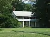 Samuel Caldwell House |
March 11, 1980 (#80003201) |
East and Locust Sts. 39°44′40″N 81°30′47″W |
Caldwell | |
| 3 | Samuel Danford Farm, Church and Cemetery | 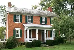 Samuel Danford Farm, Church and Cemetery |
March 27, 1980 (#80003204) |
North of Summerfield on County Road 5-A 39°51′31″N 81°20′56″W |
Marion Township | |
| 4 | Huffman Covered Bridge | 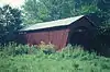 Huffman Covered Bridge |
March 4, 1975 (#75001513) |
1.5 miles south of Middleburg off State Route 564 39°39′37″N 81°22′13″W |
Jefferson Township | Destroyed |
| 5 | Noble County Jail and Sheriff's Office |  Noble County Jail and Sheriff's Office |
February 20, 2004 (#04000060) |
419 West St. 39°44′51″N 81°31′01″W |
Caldwell | |
| 6 | St. Henry Roman Catholic Church and Rectory |  St. Henry Roman Catholic Church and Rectory |
December 2, 1982 (#82001485) |
36573 County Road 47 at Harriettsville 39°37′46″N 81°20′18″W |
Elk Township | |
| 7 | St. Mary's Church of the Immaculate Conception | 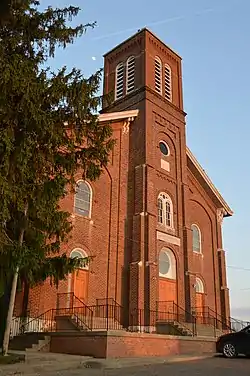 St. Mary's Church of the Immaculate Conception |
July 21, 1980 (#80003202) |
Off State Route 564 at Fulda 39°43′26″N 81°24′55″W |
Enoch Township | |
| 8 | SHENANDOAH Crash Sites | 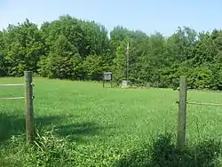 SHENANDOAH Crash Sites |
July 25, 1989 (#89000942) |
Near Interstate 77 and County Road 37 (near Ava), and State Route 78 west of Caldwell 39°50′21″N 81°32′22″W |
Buffalo, Noble, and Sharon Townships | |
| 9 | Abner Williams Log House | 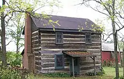 Abner Williams Log House |
June 20, 1979 (#79001923) |
Northeast of Lashley 39°56′46″N 81°21′38″W |
Wayne Township | |
| 10 | Young-Shaw House | 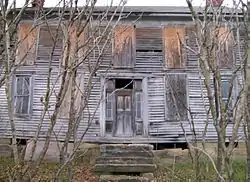 Young-Shaw House |
February 8, 1980 (#80003203) |
East of Sarahsville on State Route 146 39°48′18″N 81°26′06″W |
Center Township | Torn down |
See also
| Wikimedia Commons has media related to National Register of Historic Places in Noble County, Ohio. |
References
- The latitude and longitude information provided in this table was derived originally from the National Register Information System, which has been found to be fairly accurate for about 99% of listings. Some locations in this table may have been corrected to current GPS standards.
- "National Register of Historic Places: Weekly List Actions". National Park Service, United States Department of the Interior. Retrieved on January 29, 2021.
- Numbers represent an alphabetical ordering by significant words. Various colorings, defined here, differentiate National Historic Landmarks and historic districts from other NRHP buildings, structures, sites or objects.
- "National Register Information System". National Register of Historic Places. National Park Service. April 24, 2008.
- The eight-digit number below each date is the number assigned to each location in the National Register Information System database, which can be viewed by clicking the number.

Municipalities and communities of Noble County, Ohio, United States | ||
|---|---|---|
| Villages | Map of Ohio highlighting Noble County | |
| Townships | ||
| Unincorporated communities | ||
| ||
This article is issued from Wikipedia. The text is licensed under Creative Commons - Attribution - Sharealike. Additional terms may apply for the media files.