National Register of Historic Places listings in Hancock County, Ohio
This is a list of the National Register of Historic Places listings in Hancock County, Ohio.
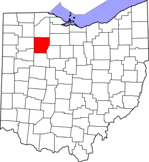
Location of Hancock County in Ohio
This is intended to be a complete list of the properties and districts on the National Register of Historic Places in Hancock County, Ohio, United States. The locations of National Register properties and districts for which the latitude and longitude coordinates are included below, may be seen in an online map.[1]
There are 14 properties and districts listed on the National Register in the county.
- This National Park Service list is complete through NPS recent listings posted January 29, 2021.[2]
Current listings
| [3] | Name on the Register[4] | Image | Date listed[5] | Location | City or town | Description |
|---|---|---|---|---|---|---|
| 1 | Adams School |  Adams School |
August 11, 2004 (#04000832) |
826 Washington St. 41°02′32″N 83°39′45″W |
Findlay | |
| 2 | Charles H. Bigelow House |  Charles H. Bigelow House |
March 29, 2006 (#06000200) |
2816 N. Main St. 41°04′24″N 83°39′00″W |
Findlay | |
| 3 | The Boss Manufacturing Company | 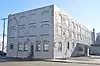 The Boss Manufacturing Company |
September 6, 2018 (#100002879) |
317 W. Main Cross St. 41°02′21″N 83°39′17″W |
Findlay | |
| 4 | Marcus Dana House | 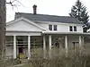 Marcus Dana House |
March 24, 1980 (#80003095) |
707 N. County Line St. 41°09′57″N 83°25′17″W |
Fostoria | |
| 5 | Findlay Country Club Golf Course | 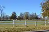 Findlay Country Club Golf Course |
December 2, 2019 (#100004705) |
1500 Country Club Dr. 41°02′48″N 83°37′22″W |
Findlay | |
| 6 | Findlay Downtown Historic District | 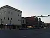 Findlay Downtown Historic District |
February 28, 1985 (#85000402) |
Roughly along Main, W. Sandusky, and W. Main Cross Sts. 41°02′13″N 83°39′01″W |
Findlay | |
| 7 | First Hancock County Courthouse | 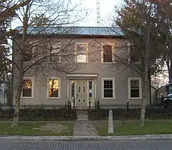 First Hancock County Courthouse |
March 13, 1976 (#76001454) |
819 Park St. 41°01′56″N 83°38′37″W |
Findlay | |
| 8 | Fostoria Mausoleum |  Fostoria Mausoleum |
August 25, 1978 (#78002085) |
702 Van Buren St. 41°09′51″N 83°25′39″W |
Fostoria | |
| 9 | Hancock County Courthouse | 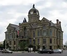 Hancock County Courthouse |
May 7, 1973 (#73001475) |
Courthouse Sq. 41°02′20″N 83°39′02″W |
Findlay | |
| 10 | Jasper G. Hull House | 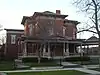 Jasper G. Hull House |
May 7, 1973 (#73001476) |
422 W. Sandusky St. 41°02′14″N 83°39′21″W |
Findlay | |
| 11 | Elijah Pelton Jones House | 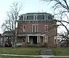 Elijah Pelton Jones House |
March 14, 1985 (#85000563) |
313 E. Sandusky St. 41°02′12″N 83°38′45″W |
Findlay | |
| 12 | Dr. Albert Linaweaver House | 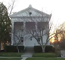 Dr. Albert Linaweaver House |
September 29, 1983 (#83001988) |
1224 S. Main St. 41°01′33″N 83°39′02″W |
Findlay | |
| 13 | Marion Township School District No. 3 |  Marion Township School District No. 3 |
August 8, 1996 (#96000883) |
8884 County Road 236 41°02′17″N 83°35′35″W |
Marion Township | |
| 14 | Andrew Powell Homestead |  Andrew Powell Homestead |
December 19, 1986 (#86003449) |
9821 County Road 313 41°00′24″N 83°41′32″W |
Liberty Township |
See also
| Wikimedia Commons has media related to National Register of Historic Places in Hancock County, Ohio. |
References
- The latitude and longitude information provided in this table was derived originally from the National Register Information System, which has been found to be fairly accurate for about 99% of listings. Some locations in this table may have been corrected to current GPS standards.
- "National Register of Historic Places: Weekly List Actions". National Park Service, United States Department of the Interior. Retrieved on January 29, 2021.
- Numbers represent an alphabetical ordering by significant words. Various colorings, defined here, differentiate National Historic Landmarks and historic districts from other NRHP buildings, structures, sites or objects.
- "National Register Information System". National Register of Historic Places. National Park Service. April 24, 2008.
- The eight-digit number below each date is the number assigned to each location in the National Register Information System database, which can be viewed by clicking the number.

Municipalities and communities of Hancock County, Ohio, United States | ||
|---|---|---|
| Cities | Map of Ohio highlighting Hancock County | |
| Villages | ||
| Townships | ||
| Unincorporated communities | ||
| Footnotes | ‡This populated place also has portions in an adjacent county or counties | |
| ||
This article is issued from Wikipedia. The text is licensed under Creative Commons - Attribution - Sharealike. Additional terms may apply for the media files.