National Register of Historic Places listings in Auglaize County, Ohio
This is a list of the National Register of Historic Places listings in Auglaize County, Ohio.
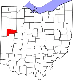
Location of Auglaize County in Ohio
This is intended to be a complete list of the properties and districts on the National Register of Historic Places in Auglaize County, Ohio, United States. The locations of National Register properties and districts for which the latitude and longitude coordinates are included below, may be seen in a Google map.[1]
There are 24 properties and districts listed on the National Register in the county, including 1 National Historic Landmark.
- This National Park Service list is complete through NPS recent listings posted January 29, 2021.[2]
Current listings
| [3] | Name on the Register[4] | Image | Date listed[5] | Location | City or town | Description |
|---|---|---|---|---|---|---|
| 1 | Auglaize County Courthouse | 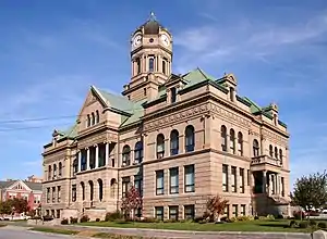 Auglaize County Courthouse |
May 7, 1973 (#73001387) |
Courthouse Sq. 40°34′06″N 84°11′40″W |
Wapakoneta | |
| 2 | Blume High School | 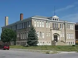 Blume High School |
August 22, 1996 (#96000933) |
405-409 S. Blackhoof St. 40°33′58″N 84°11′50″W |
Wapakoneta | |
| 3 | Adolph Boesel House |  Adolph Boesel House |
November 29, 1979 (#79001784) |
110 S. Franklin St. 40°26′04″N 84°23′01″W |
New Bremen | Destroyed.[6] The house was moved to 400 Easthaven Dr., New Bremen, Ohio |
| 4 | Julius Boesel House | 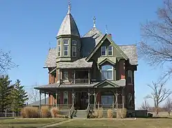 Julius Boesel House |
March 30, 1978 (#78002008) |
North of New Bremen on Quellhorst Rd. 40°26′56″N 84°22′40″W |
German Township | |
| 5 | Egypt Catholic Church and Rectory | 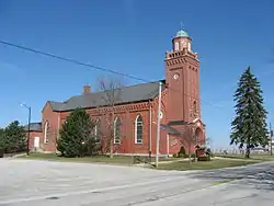 Egypt Catholic Church and Rectory |
July 26, 1979 (#79003455) |
Junction of Minster-Egypt Rd. and State Route 364 at Egypt 40°23′05″N 84°26′04″W |
Jackson Township | |
| 6 | First Presbyterian Church of Wapakoneta | 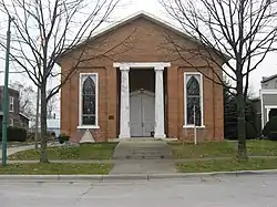 First Presbyterian Church of Wapakoneta |
August 23, 1985 (#85001797) |
106 W. Main St. 40°34′11″N 84°11′48″W |
Wapakoneta | |
| 7 | H.E. Fledderjohann House, Doctor's Office and Summer Kitchen | 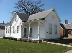 H.E. Fledderjohann House, Doctor's Office and Summer Kitchen |
December 10, 1993 (#93001388) |
107 E. German St. 40°29′36″N 84°18′56″W |
New Knoxville | |
| 8 | Fort Amanda Site | 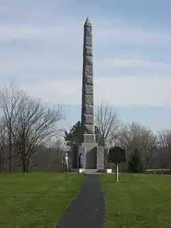 Fort Amanda Site |
November 10, 1970 (#70000484) |
9 mi (14 km) northwest of Wapakoneta on State Route 198 40°40′53″N 84°16′06″W |
Logan Township | |
| 9 | The Fountain Hotel | 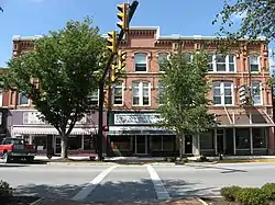 The Fountain Hotel |
December 19, 1997 (#97001564) |
100-110 W. Spring St. 40°32′34″N 84°23′20″W |
St. Marys | |
| 10 | Glynnwood Catholic Church | 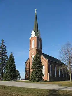 Glynnwood Catholic Church |
July 26, 1979 (#79003454) |
6 mi (9.7 km) northeast of St. Marys on Glynnwood Rd. in Glynnwood 40°34′59″N 84°19′05″W |
Moulton Township | |
| 11 | Holy Rosary Catholic Church | 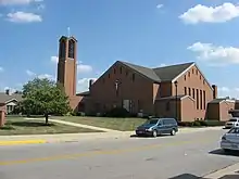 Holy Rosary Catholic Church |
July 26, 1979 (#79003456) |
Junction of E. Spring and S. Pine Sts. 40°32′42″N 84°22′58″W |
St. Marys | Destroyed and replaced with a modern structure |
| 12 | William Luelleman House | 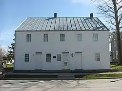 William Luelleman House |
May 21, 1975 (#75001322) |
122 N. Main St. 40°26′20″N 84°22′56″W |
New Bremen | |
| 13 | Miami and Erie Canal Deep Cut |  Miami and Erie Canal Deep Cut |
October 15, 1966 (#66000603) |
2 mi (3.2 km) south of Spencerville on State Route 66 40°41′06″N 84°21′57″W |
Salem Township | Extends into Spencer Township in Allen County |
| 14 | Minster Elementary School |  Minster Elementary School |
July 26, 1979 (#79002850) |
Lincoln St. 40°23′42″N 84°22′44″W |
Minster | |
| 15 | John H. Nichols House | 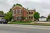 John H. Nichols House |
July 14, 1988 (#88001064) |
103 S. Blackhoof St. 40°34′10″N 84°11′47″W |
Wapakoneta | |
| 16 | Hugh T. Rinehart House | 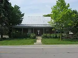 Hugh T. Rinehart House |
November 27, 1978 (#78002009) |
22011 State Route 67, east of Uniopolis[7] 40°36′02″N 84°01′57″W |
Union Township | |
| 17 | Round Barn | 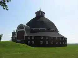 Round Barn |
April 17, 1980 (#80002942) |
Along State Route 385, 3 mi (4.8 km) east of New Hampshire 40°33′24″N 83°53′35″W |
Goshen Township | |
| 18 | St. Augustine Catholic Church | 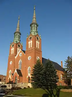 St. Augustine Catholic Church |
July 26, 1979 (#79003457) |
N. Hanover St. 40°23′40″N 84°22′47″W |
Minster | |
| 19 | St. John Catholic Church and Parish Hall | 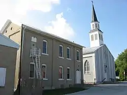 St. John Catholic Church and Parish Hall |
July 26, 1979 (#79003451) |
Southwestern corner of Schlemel and Van Buren Sts. in Fryburg 40°30′58″N 84°08′54″W |
Pusheta Township | |
| 20 | St. Joseph Catholic Church and School | 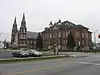 St. Joseph Catholic Church and School |
July 26, 1979 (#79003453) |
309 S. Perry St. 40°34′04″N 84°11′43″W |
Wapakoneta | |
| 21 | Uniopolis Town Hall | 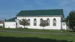 Uniopolis Town Hall |
July 22, 1994 (#94000773) |
Ohio St. (State Route 67) east of its junction with Main St. 40°36′08″N 84°05′15″W |
Uniopolis | |
| 22 | Wapakoneta Commercial Historic District | 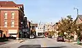 Wapakoneta Commercial Historic District |
January 5, 1989 (#88003131) |
Roughly bounded by Auglaize, Park, Main, and Blackhoof Sts. 40°34′12″N 84°11′39″W |
Wapakoneta | |
| 23 | Dr. Issac Elmer Williams House and Office | 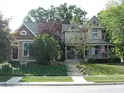 Dr. Issac Elmer Williams House and Office |
May 8, 1979 (#79001785) |
407-411 N. Main St. 40°32′44″N 84°23′34″W |
St. Marys | |
| 24 | Charles Wintzer Building | 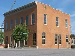 Charles Wintzer Building |
July 8, 2010 (#10000455) |
202 W. Auglaize St. 40°34′15″N 84°11′47″W |
Wapakoneta |
See also
| Wikimedia Commons has media related to National Register of Historic Places in Auglaize County, Ohio. |
References
- The latitude and longitude information provided in this table was derived originally from the National Register Information System, which has been found to be fairly accurate for about 99% of listings. Some locations in this table may have been corrected to current GPS standards.
- "National Register of Historic Places: Weekly List Actions". National Park Service, United States Department of the Interior. Retrieved on January 29, 2021.
- Numbers represent an alphabetical ordering by significant words. Various colorings, defined here, differentiate National Historic Landmarks and historic districts from other NRHP buildings, structures, sites or objects.
- "National Register Information System". National Register of Historic Places. National Park Service. April 24, 2008.
- The eight-digit number below each date is the number assigned to each location in the National Register Information System database, which can be viewed by clicking the number.
- Boesel, Adolph, House, Ohio Historical Society, 2007. Accessed 2010-03-16.
- Address visible in this picture of the house; the NRIS lists it as "East of Uniopolis on State Route 67."

Municipalities and communities of Auglaize County, Ohio, United States | ||
|---|---|---|
| Cities | Map of Ohio highlighting Auglaize County | |
| Villages | ||
| Townships | ||
| CDPs | ||
| Unincorporated communities | ||
| Ghost towns |
| |
| Footnotes | ‡This populated place also has portions in an adjacent county or counties | |
| ||
This article is issued from Wikipedia. The text is licensed under Creative Commons - Attribution - Sharealike. Additional terms may apply for the media files.