National Register of Historic Places listings in Huron County, Ohio
This is a list of the National Register of Historic Places listings in Huron County, Ohio.
Location of Huron County in Ohio
This is intended to be a complete list of the properties and districts on the National Register of Historic Places in Huron County, Ohio, United States. The locations of National Register properties and districts for which the latitude and longitude coordinates are included below, may be seen in an online map.[1]
There are 17 properties and districts listed on the National Register in the county. Another 2 properties were once listed but have been removed.
- This National Park Service list is complete through NPS recent listings posted January 29, 2021.[2]
Current listings
| [3] | Name on the Register[4] | Image | Date listed[5] | Location | City or town | Description |
|---|---|---|---|---|---|---|
| 1 | Seth Brown House | 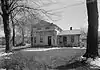 Seth Brown House |
May 3, 1974 (#74001531) |
29 Brown St. 41°14′41″N 82°41′49″W |
Monroeville | |
| 2 | Dunton House |  Dunton House |
December 16, 1982 (#82001469) |
130 Benedict Ave. 41°14′13″N 82°36′43″W |
Norwalk | |
| 3 | Gregory House | 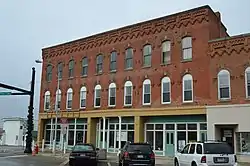 Gregory House |
February 24, 1984 (#84003746) |
1 E. Main St. 41°05′08″N 82°23′57″W |
New London | |
| 4 | John Hosford House |  John Hosford House |
May 3, 1974 (#74001532) |
64 Sandusky St. 41°14′45″N 82°41′46″W |
Monroeville | |
| 5 | Hunts Corners | 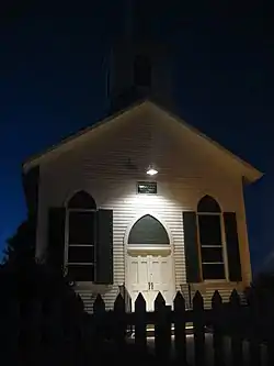 Hunts Corners |
September 2, 1993 (#93000896) |
Junction of Sandhill Rd. and State Route 547 at Hunts Corners 41°13′37″N 82°45′26″W |
Lyme Township | One of Huron County's oldest communities, founded in 1811 |
| 6 | Huron County Children's Home | 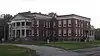 Huron County Children's Home |
October 27, 2004 (#04001200) |
190 Benedict Ave. 41°13′55″N 82°36′30″W |
Norwalk | |
| 7 | Huron County Courthouse and Jail | 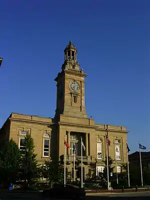 Huron County Courthouse and Jail |
July 12, 1974 (#74001534) |
E. Main St. and Benedict Ave. 41°14′31″N 82°36′55″W |
Norwalk | |
| 8 | Macksville Tavern | 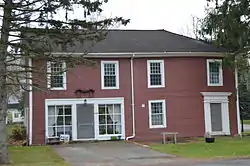 Macksville Tavern |
May 3, 1976 (#76001457) |
Peru Hollow Rd. 41°10′11″N 82°38′32″W |
Peru Township | |
| 9 | Mead-Zimmerman House | 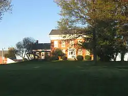 Mead-Zimmerman House |
March 30, 1978 (#78002089) |
East of Greenwich on State Route 13 41°00′56″N 82°29′08″W |
Greenwich Township | |
| 10 | Miller-Bissell Farmstead | 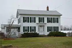 Miller-Bissell Farmstead |
September 23, 2002 (#02001058) |
581 State Route 60, north of New London 41°07′19″N 82°24′34″W |
New London Township | |
| 11 | Norwalk Memorial Hospital | 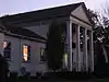 Norwalk Memorial Hospital |
June 21, 2007 (#07000582) |
269 W. Main St. 41°14′01″N 82°38′17″W |
Norwalk | |
| 12 | Phoenix Mills |  Phoenix Mills |
May 28, 1975 (#75001440) |
East of Steuben on Mill Rd. 41°05′57″N 82°39′53″W |
Greenfield Township | |
| 13 | Plymouth Historic District | 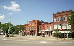 Plymouth Historic District |
December 7, 2018 (#100003245) |
Roughly bounded by Dix, Trux, Mills, and New Railroad Sts. 40°59′43″N 82°40′02″W |
Plymouth | Extends into Richland County |
| 14 | Tremont House |  Tremont House |
March 31, 2006 (#06000201) |
101-103 E. Main St. 41°16′26″N 82°50′26″W |
Bellevue | |
| 15 | West Main Street District | 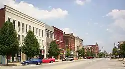 West Main Street District |
February 27, 1974 (#74001535) |
In an irregular pattern, both sides of W. Main St. for 6 blocks from the western edge of business district 41°14′20″N 82°37′30″W |
Norwalk | |
| 16 | John Wright Mansion | 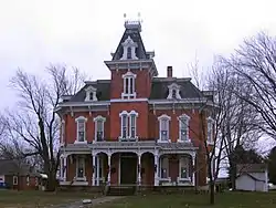 John Wright Mansion |
February 27, 1974 (#74001530) |
State Route 113 west of State Route 4, northeast of Bellevue 41°16′53″N 82°47′25″W |
Lyme Township | |
| 17 | Zion Episcopal Church | 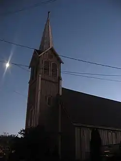 Zion Episcopal Church |
May 3, 1974 (#74001533) |
Ridge St. at Monroe St. 41°14′35″N 82°42′13″W |
Monroeville |
Former listings
| [3] | Name on the Register | Image | Date listed | Date removed | Location | City or town | Summary |
|---|---|---|---|---|---|---|---|
| 1 | Baltimore and Ohio Railroad Depot | Unavailable (#75002166) | 1978 | B&O RR jct. |
Willard | Former B&O railroad junction | |
| 2 | Dr. David De Forest Benedict House |  Dr. David De Forest Benedict House |
January 23, 1975 (#75001439) | May 12, 2016 | 80 Seminary St. 41°14′34″N 82°36′42″W |
Norwalk |
See also
| Wikimedia Commons has media related to National Register of Historic Places in Huron County, Ohio. |
References
- The latitude and longitude information provided in this table was derived originally from the National Register Information System, which has been found to be fairly accurate for about 99% of listings. Some locations in this table may have been corrected to current GPS standards.
- "National Register of Historic Places: Weekly List Actions". National Park Service, United States Department of the Interior. Retrieved on January 29, 2021.
- Numbers represent an alphabetical ordering by significant words. Various colorings, defined here, differentiate National Historic Landmarks and historic districts from other NRHP buildings, structures, sites or objects.
- "National Register Information System". National Register of Historic Places. National Park Service. March 13, 2009.
- The eight-digit number below each date is the number assigned to each location in the National Register Information System database, which can be viewed by clicking the number.

Municipalities and communities of Huron County, Ohio, United States | ||
|---|---|---|
| Cities | Map of Ohio highlighting Huron County | |
| Villages | ||
| Townships | ||
| CDPs | ||
| Unincorporated communities | ||
| Footnotes | ‡This populated place also has portions in an adjacent county or counties | |
| ||
This article is issued from Wikipedia. The text is licensed under Creative Commons - Attribution - Sharealike. Additional terms may apply for the media files.