National Register of Historic Places listings in Miami County, Ohio
This is a list of the National Register of Historic Places listings in Miami County, Ohio.
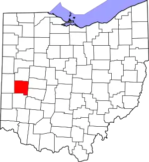
Location of Miami County in Ohio
This is intended to be a complete list of the properties and districts on the National Register of Historic Places in Miami County, Ohio, United States. The locations of National Register properties and districts for which the latitude and longitude coordinates are included below, may be seen in an online map.[1]
There are 45 properties and districts listed on the National Register in the county, including one National Historic Landmark.
- This National Park Service list is complete through NPS recent listings posted January 29, 2021.[2]
Current listings
| [3] | Name on the Register[4] | Image | Date listed[5] | Location | City or town | Description |
|---|---|---|---|---|---|---|
| 1 | African Jackson Cemetery |  African Jackson Cemetery |
December 16, 1982 (#82001475) |
North of Piqua on Zimmerlin Rd. 40°09′25″N 84°14′07″W |
Springcreek Township | |
| 2 | Arrowston | 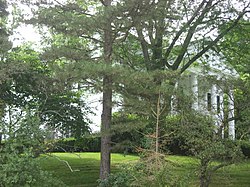 Arrowston |
February 8, 1980 (#80003162) |
1220 Park Ave. 40°09′14″N 84°15′34″W |
Piqua | |
| 3 | William Baumgardner House and Farm Buildings |  William Baumgardner House and Farm Buildings |
February 17, 1978 (#78002141) |
8390 National Rd., southwest of New Carlisle 39°54′22″N 84°03′35″W |
Bethel Township | |
| 4 | Bradford Junction Interlocking Tower |  Bradford Junction Interlocking Tower |
April 20, 1995 (#95000497) |
501 E. Main St. 40°07′52″N 84°25′29″W |
Bradford | |
| 5 | Casstown Lutheran Stone Church | 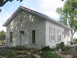 Casstown Lutheran Stone Church |
May 31, 1984 (#84003783) |
11 S. Main St. 40°03′05″N 84°07′46″W |
Casstown | |
| 6 | Covington Historic Government Building |  Covington Historic Government Building |
June 22, 1981 (#81000447) |
Spring and Pearl Sts. 40°06′59″N 84°21′12″W |
Covington | |
| 7 | Robert Culbertson House |  Robert Culbertson House |
October 10, 1975 (#75001489) |
304 E. Franklin St. 40°02′13″N 84°12′05″W |
Troy | |
| 8 | Detrick Milling and Distilling Company |  Detrick Milling and Distilling Company |
April 15, 2010 (#10000193) |
128 W. Broadway 39°57′33″N 84°10′25″W |
Tipp City | |
| 9 | William K. Dunlap House |  William K. Dunlap House |
December 12, 1976 (#76001492) |
16 E. Franklin St. 40°02′17″N 84°12′13″W |
Troy | |
| 10 | John Minor Dye Stone House |  John Minor Dye Stone House |
July 7, 1983 (#83002008) |
9 S. Children's Home Rd., east of Troy 40°01′49″N 84°08′06″W |
Elizabeth Township | |
| 11 | Eldean Covered Bridge | 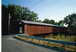 Eldean Covered Bridge |
February 20, 1975 (#75001492) |
North of Troy across the Great Miami River on County Road 33 40°04′40″N 84°13′00″W |
Concord and Staunton Townships | |
| 12 | Elizabeth Township Rural Historic District | 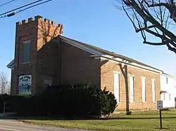 Elizabeth Township Rural Historic District |
March 1, 1997 (#97000160) |
Roughly bounded by Lost Creek, the Miami and Clark County line, and Casstown Clark County and Elizabeth Bethel Rds. 40°00′45″N 84°05′53″W |
Elizabeth Township | |
| 13 | First Presbyterian Church |  First Presbyterian Church |
December 12, 1976 (#76001493) |
Franklin and Walnut Sts. 40°02′17″N 84°12′11″W |
Troy | |
| 14 | Fort Piqua Hotel |  Fort Piqua Hotel |
February 15, 1974 (#74001576) |
114 W. Main St. 40°08′56″N 84°14′24″W |
Piqua | |
| 15 | Mary Jane Hayner House |  Mary Jane Hayner House |
January 30, 1976 (#76001494) |
301 W. Main St. 40°02′26″N 84°12′22″W |
Troy | |
| 16 | Hobart Circle Historic District |  Hobart Circle Historic District |
May 25, 1989 (#89000419) |
2-9 Hobart Cir. and 11 and 23 Hobart Dr. 40°02′31″N 84°12′35″W |
Troy | |
| 17 | E.A. Hobart House | 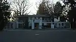 E.A. Hobart House |
May 25, 1989 (#89000420) |
172 S. Ridge Ave. 40°02′35″N 84°13′12″W |
Troy | |
| 18 | William Hobart Vacation House |  William Hobart Vacation House |
May 25, 1989 (#89000421) |
905 Polecat Rd., north of Troy 40°04′35″N 84°11′24″W |
Staunton Township | |
| 19 | House at 121 South Ridge |  House at 121 South Ridge |
May 25, 1989 (#89000425) |
121 S. Ridge Ave. 40°02′41″N 84°13′03″W |
Troy | |
| 20 | House at 129 South Ridge | 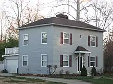 House at 129 South Ridge |
May 25, 1989 (#89000423) |
129 S. Ridge Ave. 40°02′39″N 84°13′03″W |
Troy | |
| 21 | House at 145 South Ridge |  House at 145 South Ridge |
May 25, 1989 (#89000426) |
145 S. Ridge Ave. 40°02′37″N 84°13′03″W |
Troy | |
| 22 | House at 203 Penn Road |  House at 203 Penn Road |
May 25, 1989 (#89000422) |
203 Penn Rd. 40°02′33″N 84°12′56″W |
Troy | |
| 23 | House at 1022 West Main Street |  House at 1022 West Main Street |
May 25, 1989 (#89000424) |
1022 W. Main St. 40°02′42″N 84°13′02″W |
Troy | |
| 24 | Benjamin Iddings Log House | 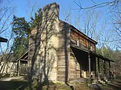 Benjamin Iddings Log House |
November 21, 1976 (#76001497) |
6.5 mi (10.5 km) west of Troy 40°00′58″N 84°19′05″W |
Newton Township | |
| 25 | Lockington Locks Historical Area |  Lockington Locks Historical Area |
December 17, 1969 (#69000147) |
Miami and Erie Canal between Lockington and Washington Township 40°11′22″N 84°14′31″W |
Washington Township | Extends into Lockington and Washington Township in Shelby County |
| 26 | McKinley School | 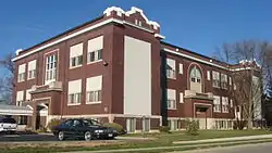 McKinley School |
April 22, 2005 (#05000025) |
240 S. Main St. 39°57′35″N 84°19′39″W |
West Milton | |
| 27 | Miami County Courthouse and Power Station |  Miami County Courthouse and Power Station |
May 30, 1975 (#75001490) |
Bounded by Main, Short, Plum, and Water Sts. 40°02′27″N 84°12′18″W |
Troy | |
| 28 | Newberry Township School |  Newberry Township School |
July 3, 2012 (#12000395) |
4045 State Route 721, south of Bradford 40°05′40″N 84°25′46″W |
Newberry Township | |
| 29 | Old Tippecanoe Main Street Historic District |  Old Tippecanoe Main Street Historic District |
July 7, 1983 (#83002009) |
5-439 W. Main St. and 3-225 E. Main St. 39°57′40″N 84°10′02″W |
Tipp City | |
| 30 | Overfield Tavern | 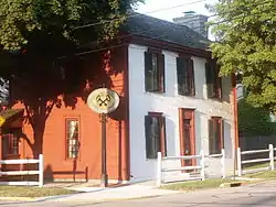 Overfield Tavern |
January 30, 1976 (#76001495) |
201 E. Water St. 40°02′23″N 84°12′02″W |
Troy | One of Ohio's oldest taverns, built in 1808. Now a museum. |
| 31 | Piqua High School | 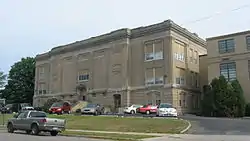 Piqua High School |
August 22, 1996 (#96000927) |
316 N. College St. 40°08′56″N 84°14′57″W |
Piqua | Built in 1914, converted to 78 senior housing units in 1995 |
| 32 | Piqua Historical Area State Memorial |  Piqua Historical Area State Memorial |
April 7, 1971 (#71000646) |
State Route 66, 1 mi (1.6 km) north of Piqua 40°10′45″N 84°15′21″W |
Washington Township | |
| 33 | Piqua-Caldwell Historic District |  Piqua-Caldwell Historic District |
January 11, 1985 (#85000069) |
N. Main, Wayne, Downing, Caldwell Sts; W. Ash to Camp Sts. 40°08′59″N 84°14′22″W |
Piqua | |
| 34 | Plainview Farm |  Plainview Farm |
April 18, 1985 (#85000857) |
535-545 Weddle Rd., southeast of Casstown 40°02′08″N 84°05′30″W |
Elizabeth Township | |
| 35 | Pleasant Hill United Church of Christ |  Pleasant Hill United Church of Christ |
August 22, 2002 (#02000881) |
10 W. Monument St. 40°03′07″N 84°20′43″W |
Pleasant Hill | |
| 36 | York Rial House |  York Rial House |
August 12, 1986 (#86002620) |
McFarland St., north of Piqua 40°09′23″N 84°14′12″W |
Springcreek Township | |
| 37 | Elizabeth Sheets Saunders Farm |  Elizabeth Sheets Saunders Farm |
November 21, 1976 (#76001491) |
4525 McCandless Rd., southeast of Casstown 40°02′16″N 84°07′18″W |
Elizabeth Township | |
| 38 | Saunders Seed Company |  Saunders Seed Company |
April 13, 2010 (#10000194) |
101 W. Broadway 40°02′16″N 84°07′18″W |
Tipp City | |
| 39 | Andrew Sheets House |  Andrew Sheets House |
February 1, 1988 (#87002522) |
6880 LaFevre Rd. 40°01′34″N 84°04′36″W |
Elizabeth Township | |
| 40 | Staley Farm |  Staley Farm |
March 24, 1980 (#80003161) |
North of Brandt at 7095 Staley Rd. 39°58′01″N 84°04′42″W |
Bethel Township | |
| 41 | Troy Public Square | 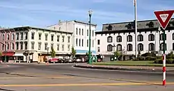 Troy Public Square |
June 30, 1975 (#75001491) |
Property surrounding the junction of Main and Market Sts. 40°02′22″N 84°12′12″W |
Troy | |
| 42 | Twin Arch Stone Culvert | 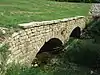 Twin Arch Stone Culvert |
July 17, 1978 (#78002142) |
North of Troy at County Road 25A 40°05′18″N 84°13′24″W |
Concord Township | |
| 43 | Callahill and Priscilla Weddle House | 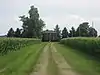 Callahill and Priscilla Weddle House |
June 18, 1987 (#87000986) |
5710 LeFevre Rd., east of Troy 40°01′32″N 84°05′59″W |
Elizabeth Township | |
| 44 | Judge Henry Williams House |  Judge Henry Williams House |
January 1, 1976 (#76001496) |
16 S. Cherry St. 40°02′22″N 84°12′17″W |
Troy | |
| 45 | S. Zollinger Company Building |  S. Zollinger Company Building |
December 15, 2015 (#15000903) |
101 S. Wayne St. 40°08′47″N 84°14′26″W |
Piqua |
See also
| Wikimedia Commons has media related to National Register of Historic Places in Miami County, Ohio. |
References
- The latitude and longitude information provided in this table was derived originally from the National Register Information System, which has been found to be fairly accurate for about 99% of listings. Some locations in this table may have been corrected to current GPS standards.
- "National Register of Historic Places: Weekly List Actions". National Park Service, United States Department of the Interior. Retrieved on January 29, 2021.
- Numbers represent an alphabetical ordering by significant words. Various colorings, defined here, differentiate National Historic Landmarks and historic districts from other NRHP buildings, structures, sites or objects.
- "National Register Information System". National Register of Historic Places. National Park Service. April 24, 2008.
- The eight-digit number below each date is the number assigned to each location in the National Register Information System database, which can be viewed by clicking the number.

Municipalities and communities of Miami County, Ohio, United States | ||
|---|---|---|
| Cities | Map of Ohio highlighting Miami County | |
| Villages | ||
| Townships | ||
| Unincorporated communities | ||
| Footnotes | ‡This populated place also has portions in an adjacent county or counties | |
| ||
This article is issued from Wikipedia. The text is licensed under Creative Commons - Attribution - Sharealike. Additional terms may apply for the media files.