National Register of Historic Places listings in Fayette County, Ohio
This is a list of the National Register of Historic Places listings in Fayette County, Ohio.

Location of Fayette County in Ohio
This is intended to be a complete list of the properties and districts on the National Register of Historic Places in Fayette County, Ohio, United States. The locations of National Register properties and districts for which the latitude and longitude coordinates are included below, may be seen in a Google map.[1]
There are 17 properties and districts listed on the National Register in the county.
- This National Park Service list is complete through NPS recent listings posted January 29, 2021.[2]
Current listings
| [3] | Name on the Register[4] | Image | Date listed[5] | Location | City or town | Description |
|---|---|---|---|---|---|---|
| 1 | William Burnett House |  William Burnett House |
March 22, 1989 (#89000176) |
1613 U.S. Route 62, SW. 39°31′28″N 83°27′30″W |
Washington Court House | Destroyed[6] |
| 2 | Fayette County Courthouse | 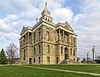 Fayette County Courthouse |
July 2, 1973 (#73001433) |
Main and Columbus Sts. 39°32′11″N 83°26′24″W |
Washington Court House | |
| 3 | Jackson Mound | 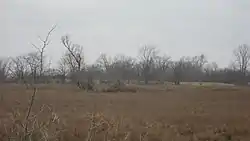 Jackson Mound |
October 21, 1975 (#75001397) |
East of State Route 207, 4 miles (6.4 km) north of Pancoastburg[7] 39°40′40″N 83°15′55″W |
Madison Township | |
| 4 | Judy Chapel | 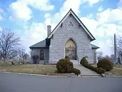 Judy Chapel |
May 8, 1998 (#98000441) |
1741 Washington Ave. 39°32′23″N 83°25′16″W |
Washington Court House | |
| 5 | Barney Kelley House | 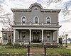 Barney Kelley House |
April 17, 1979 (#79001834) |
321 E. East St. 39°32′12″N 83°26′10″W |
Washington Court House | |
| 6 | Jacob Light House | 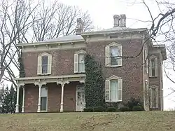 Jacob Light House |
January 13, 1989 (#88003191) |
123 W. Circle Ave. 39°31′53″N 83°26′13″W |
Washington Court House | |
| 7 | Mark Road Bridge | 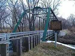 Mark Road Bridge |
July 26, 1990 (#90001118) |
Mark Rd. over Sugar Creek, north of Staunton 39°29′13″N 83°28′23″W |
Concord and Union Townships | |
| 8 | William McCafferty Farmhouse | 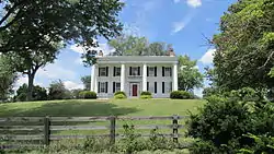 William McCafferty Farmhouse |
April 23, 1987 (#87000633) |
7099 State Route 207, NE., south of Mount Sterling 39°39′31″N 83°16′12″W |
Madison Township | |
| 9 | Rawlings-Brownell House | 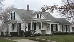 Rawlings-Brownell House |
March 10, 1988 (#88000207) |
318 Rawlings St. 39°32′29″N 83°26′28″W |
Washington Court House | |
| 10 | Robinson-Pavey House |  Robinson-Pavey House |
April 23, 1987 (#87000638) |
421 W. Court St. 39°31′57″N 83°26′39″W |
Washington Court House | |
| 11 | Morris Sharp House | 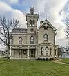 Morris Sharp House |
January 21, 1974 (#74001483) |
517 Columbus St. 39°32′21″N 83°26′06″W |
Washington Court House | |
| 12 | Edward Smith, Jr., Farm | 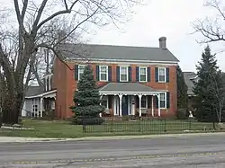 Edward Smith, Jr., Farm |
December 9, 1987 (#87002110) |
2085 U.S. Route 62, northeast of Washington Court House 39°33′16″N 83°25′10″W |
Union Township | |
| 13 | Sollars Farmstead |  Sollars Farmstead |
May 2, 1995 (#95000493) |
Along State Route 41 south of Washington Court House[6][8] 39°25′31″N 83°23′42″W |
Perry Township | |
| 14 | Washington Cemetery Historic District | 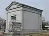 Washington Cemetery Historic District |
September 6, 2006 (#06000765) |
1741 Washington Ave. 39°32′19″N 83°25′00″W |
Washington Court House | |
| 15 | Washington Court House Commercial Historic District | 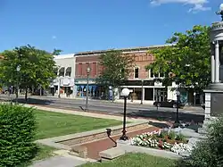 Washington Court House Commercial Historic District |
September 12, 1985 (#85002351) |
Roughly bounded by N. North, East, Hinde, and Market Sts. 39°32′09″N 83°26′20″W |
Washington Court House | |
| 16 | Washington School | 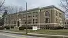 Washington School |
January 14, 2013 (#12001181) |
318 N. North St. 39°32′24″N 83°26′24″W |
Washington Court House | |
| 17 | Woodlawn Farm | 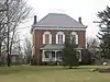 Woodlawn Farm |
February 13, 1986 (#86000237) |
3789 State Route 41, NW., northwest of Washington Court House 39°34′35″N 83°28′31″W |
Union Township |
See also
| Wikimedia Commons has media related to National Register of Historic Places in Fayette County, Ohio. |
References
- The latitude and longitude information provided in this table was derived originally from the National Register Information System, which has been found to be fairly accurate for about 99% of listings. Some locations in this table may have been corrected to current GPS standards.
- "National Register of Historic Places: Weekly List Actions". National Park Service, United States Department of the Interior. Retrieved on January 29, 2021.
- Numbers represent an alphabetical ordering by significant words. Various colorings, defined here, differentiate National Historic Landmarks and historic districts from other NRHP buildings, structures, sites or objects.
- "National Register Information System". National Register of Historic Places. National Park Service. April 24, 2008.
- The eight-digit number below each date is the number assigned to each location in the National Register Information System database, which can be viewed by clicking the number.
- Fayette County Comprehensive Land Use Strategy Plan 2006, Fayette County, p. 13., 2006. Accessed 2009-07-28.
- Location derived from Owen, Lorrie K., ed. Dictionary of Ohio Historic Places. Vol. 1. St. Clair Shores: Somerset, 1999, 409-410. The NRIS lists the site as "Address Restricted".
- U.S. Geological Survey Geographic Names Information System: Sollars Cemetery

Municipalities and communities of Fayette County, Ohio, United States | ||
|---|---|---|
| City | Map of Ohio highlighting Fayette County | |
| Villages | ||
| Townships | ||
| CDPs | ||
| Unincorporated communities |
| |
| Footnotes | ‡This populated place also has portions in an adjacent county or counties | |
| ||
This article is issued from Wikipedia. The text is licensed under Creative Commons - Attribution - Sharealike. Additional terms may apply for the media files.