National Register of Historic Places listings in Geauga County, Ohio
This is a list of the National Register of Historic Places listings in Geauga County, Ohio.
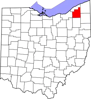
Location of Geauga County in Ohio
This is intended to be a complete list of the properties and districts on the National Register of Historic Places in Geauga County, Ohio, United States. The locations of National Register properties and districts for which the latitude and longitude coordinates are included below, may be seen in a Google map.[1]
There are 18 properties and districts listed on the National Register in the county.
- This National Park Service list is complete through NPS recent listings posted January 29, 2021.[2]
Current listings
| [3] | Name on the Register[4] | Image | Date listed[5] | Location | City or town | Description |
|---|---|---|---|---|---|---|
| 1 | ASM Headquarters and Geodesic Dome | _(5912348229).jpg.webp) ASM Headquarters and Geodesic Dome |
October 22, 2009 (#09000849) |
9639 Kinsman Rd. 41°27′36″N 81°17′56″W |
Russell Township | |
| 2 | Batavia House | 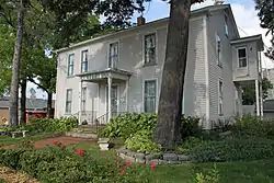 Batavia House |
July 16, 1987 (#87001213) |
14979 S. State St. 41°27′39″N 81°04′22″W |
Middlefield | |
| 3 | Burton Village Historic District |  Burton Village Historic District |
November 20, 1974 (#74001501) |
Surrounding Public Sq. 41°28′22″N 81°08′42″W |
Burton | |
| 4 | Chardon Courthouse Square District | 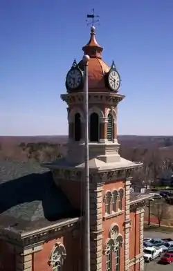 Chardon Courthouse Square District |
October 18, 1974 (#74001502) |
Public green, roughly bounded by Main and Center Sts. 41°34′56″N 81°12′14″W |
Chardon | |
| 5 | Chardon Post Office Building |  Chardon Post Office Building |
February 28, 2008 (#08000114) |
121 South St. 41°34′51″N 81°12′12″W |
Chardon | |
| 6 | Chester Township District School No. 2 | 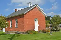 Chester Township District School No. 2 |
November 4, 1982 (#82001463) |
7798 Mayfield Rd., west of Chesterland 41°31′22″N 81°21′46″W |
Chester Township | |
| 7 | Claridon Congregational Church | 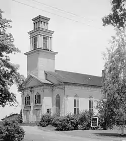 Claridon Congregational Church |
August 13, 1974 (#74001503) |
U.S. Route 322 41°31′37″N 81°08′35″W |
Claridon Township | |
| 8 | Domestic Arts Hall And Flower Hall | 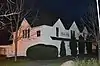 Domestic Arts Hall And Flower Hall |
August 24, 1979 (#79001846) |
N. Cheshire St. 41°28′37″N 81°08′40″W |
Burton | |
| 9 | Fowler's Mills Historic District | 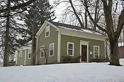 Fowler's Mills Historic District |
January 29, 2002 (#01001522) |
10743-10779, 10750 Mayfield Rd.; 12426-12533 Fowlers Mill Rd., southwest of Chardon 41°31′41″N 81°15′22″W |
Munson Township | |
| 10 | Fox-Pope Farm |  Fox-Pope Farm |
August 12, 1992 (#92000971) |
17767 Rapids Rd., west of Welshfield 41°23′12″N 81°10′17″W |
Troy Township | |
| 11 | Free Will Baptist Church of Auburn | 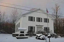 Free Will Baptist Church of Auburn |
May 28, 1976 (#76001430) |
11742 E. Washington St. 41°23′15″N 81°13′08″W |
Auburn Township | |
| 12 | Dr. Erastus Goodwin House |  Dr. Erastus Goodwin House |
August 1, 1975 (#75001406) |
14485 Main St. 41°28′28″N 81°08′41″W |
Burton | |
| 13 | Lot Hathaway House | 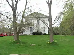 Lot Hathaway House |
October 16, 1974 (#74001504) |
12236 Old State Rd., north of East Claridon 41°32′08″N 81°07′04″W |
Claridon Township | |
| 14 | Lost Lane Farm | 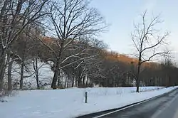 Lost Lane Farm |
August 30, 1984 (#84003693) |
18173 Geauga Lake Rd.[6] 41°22′21″N 81°21′57″W |
Bainbridge Township | Associated with Louis Rorimer; also known as Snake Hill Farm[7] |
| 15 | Pebblebrook Farm House and Gardens |  Pebblebrook Farm House and Gardens |
February 4, 2011 (#10001212) |
12525 Heath Rd., east of Chesterland 41°31′45″N 81°17′38″W |
Munson Township | |
| 16 | South Newbury Union Chapel |  South Newbury Union Chapel |
February 15, 2012 (#12000033) |
15829 Ravenna Rd. 41°26′17″N 81°12′27″W |
Newbury Township | |
| 17 | Lucius T. Tambling House | 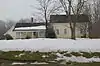 Lucius T. Tambling House |
March 15, 1984 (#84003695) |
14025 Chillicothe Rd. at Novelty 41°29′08″N 81°20′21″W |
Russell Township | |
| 18 | Walter C. White Estate | 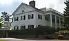 Walter C. White Estate |
October 8, 1976 (#76001431) |
East of Mayfield Heights at U.S. Route 322 and County Line Rd. 41°31′35″N 81°23′14″W |
Chester Township |
See also
| Wikimedia Commons has media related to National Register of Historic Places in Geauga County, Ohio. |
References
- The latitude and longitude information provided in this table was derived originally from the National Register Information System, which has been found to be fairly accurate for about 99% of listings. Some locations in this table may have been corrected to current GPS standards.
- "National Register of Historic Places: Weekly List Actions". National Park Service, United States Department of the Interior. Retrieved on January 29, 2021.
- Numbers represent an alphabetical ordering by significant words. Various colorings, defined here, differentiate National Historic Landmarks and historic districts from other NRHP buildings, structures, sites or objects.
- "National Register Information System". National Register of Historic Places. National Park Service. April 24, 2008.
- The eight-digit number below each date is the number assigned to each location in the National Register Information System database, which can be viewed by clicking the number.
- Location derived from Contact Us Archived 2013-11-27 at the Wayback Machine, Snake Hill Farm, 2012. Accessed 2012-03-16. The NRIS lists the property as "Address Restricted".
- Owen, Lorrie K., ed. Dictionary of Ohio Historic Places. Vol. 1. St. Clair Shores: Somerset, 1999, 532.

Municipalities and communities of Geauga County, Ohio, United States | ||
|---|---|---|
| City | Map of Ohio highlighting Geauga County | |
| Villages | ||
| Townships | ||
| CDPs | ||
| Unincorporated communities | ||
| Footnotes | ‡This populated place also has portions in an adjacent county or counties | |
| ||
This article is issued from Wikipedia. The text is licensed under Creative Commons - Attribution - Sharealike. Additional terms may apply for the media files.