National Register of Historic Places listings in Putnam County, Ohio
This is a list of the National Register of Historic Places listings in Putnam County, Ohio.
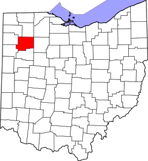
Location of Putnam County in Ohio
This is intended to be a complete list of the properties and districts on the National Register of Historic Places in Putnam County, Ohio, United States. The locations of National Register properties and districts for which the latitude and longitude coordinates are included below, may be seen in a Google map.[1]
There are 10 properties and districts listed on the National Register in the county.
- This National Park Service list is complete through NPS recent listings posted January 29, 2021.[2]
Current listings
| [3] | Name on the Register[4] | Image | Date listed[5] | Location | City or town | Description |
|---|---|---|---|---|---|---|
| 1 | Bridenbaugh District No. 3 Schoolhouse | 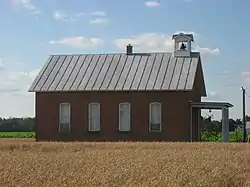 Bridenbaugh District No. 3 Schoolhouse |
April 28, 2005 (#05000343) |
Junction of County Road 6 and Township Road M6, north of Pandora 41°58′40″N 83°58′37″W |
Riley Township | |
| 2 | Columbus Grove Municipal Pool |  Columbus Grove Municipal Pool |
May 30, 1997 (#97000511) |
47510 Road P, northeast of Columbus Grove 40°55′37″N 84°01′31″W |
Pleasant Township | |
| 3 | John Edwards House | 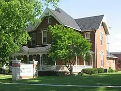 John Edwards House |
November 27, 1978 (#78002177) |
305 W. Main St. 41°06′05″N 83°59′27″W |
Leipsic | |
| 4 | Gilboa Main Street Historic District | 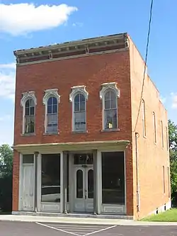 Gilboa Main Street Historic District |
February 27, 1979 (#79001927) |
Main St. 41°00′59″N 83°55′21″W |
Gilboa | |
| 5 | Dr. H. Huber Block | 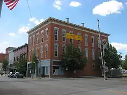 Dr. H. Huber Block |
June 4, 1980 (#80003213) |
Main St. and Taft Ave. 41°01′09″N 84°02′52″W |
Ottawa | |
| 6 | Leipsic City Hall | June 20, 1979 (#79001928) |
Belmore St. 41°05′52″N 83°59′06″W |
Leipsic | Destroyed | |
| 7 | Ottawa Waterworks Building | 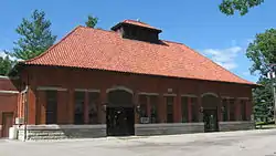 Ottawa Waterworks Building |
September 13, 1976 (#76001519) |
1035 E. 3rd St. 41°01′17″N 84°02′12″W |
Ottawa | |
| 8 | Putnam County Courthouse |  Putnam County Courthouse |
May 3, 1974 (#74001608) |
Courthouse Sq. 41°01′11″N 84°02′47″W |
Ottawa | |
| 9 | Round Barn | April 17, 1980 (#80003212) |
Road 17N south of Kalida 40°57′00″N 84°11′38″W |
Union Township | Destroyed | |
| 10 | St. John the Baptist Roman Catholic Church | 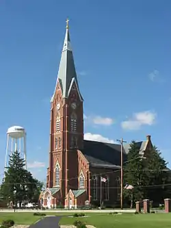 St. John the Baptist Roman Catholic Church |
June 17, 1977 (#77001083) |
State Route 694 and Main St. 41°01′50″N 84°04′46″W |
Glandorf |
See also
| Wikimedia Commons has media related to National Register of Historic Places in Putnam County, Ohio. |
References
- The latitude and longitude information provided in this table was derived originally from the National Register Information System, which has been found to be fairly accurate for about 99% of listings. Some locations in this table may have been corrected to current GPS standards.
- "National Register of Historic Places: Weekly List Actions". National Park Service, United States Department of the Interior. Retrieved on January 29, 2021.
- Numbers represent an alphabetical ordering by significant words. Various colorings, defined here, differentiate National Historic Landmarks and historic districts from other NRHP buildings, structures, sites or objects.
- "National Register Information System". National Register of Historic Places. National Park Service. April 24, 2008.
- The eight-digit number below each date is the number assigned to each location in the National Register Information System database, which can be viewed by clicking the number.

Municipalities and communities of Putnam County, Ohio, United States | ||
|---|---|---|
| Villages | Map of Ohio highlighting Putnam County | |
| Townships | ||
| CDP | ||
| Unincorporated communities | ||
| Ghost towns | ||
| ||
This article is issued from Wikipedia. The text is licensed under Creative Commons - Attribution - Sharealike. Additional terms may apply for the media files.