Grade II* listed buildings in North East Derbyshire
There are over 20,000 Grade II* listed buildings in England. This page is a list of these buildings in the district of North East Derbyshire in Derbyshire.
List of buildings
| Name | Location | Type | Completed [note 1] | Date designated | Grid ref.[note 2] Geo-coordinates |
Entry number [note 3] | Image |
|---|---|---|---|---|---|---|---|
| Barlow Woodseats | Barlow | House | 1624 | 25 October 1957 | SK3170475468 53°16′31″N 1°31′34″W |
1087802 | |
| Church of St Lawrence | Barlow | Church | Early 13th century | 31 January 1967 | SK3441974698 53°16′05″N 1°29′07″W |
1033277 | 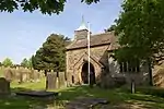 Church of St Lawrence |
| Ogston Hall and attached stable block | Brackenfield | Country house | circa 1500 | 31 January 1967 | SK3780259732 53°08′00″N 1°26′11″W |
1087805 |  Ogston Hall and attached stable block |
| Barn at Frith Hall Farm | Brampton | Cruck barn | Late 16th century | 31 January 1967 | SK3313070968 53°14′05″N 1°30′18″W |
1218534 |  Barn at Frith Hall Farm |
| Cutthorpe Hall | Brampton | Manor house | Mid-18th century | 31 January 1967 | SK3447573048 53°15′12″N 1°29′05″W |
1116985 |  |
| Aston End | Dronfield | House | 17th century | 9 January 1967 | SK3603879405 53°18′37″N 1°27′38″W |
1087766 | |
| Building to the north east of the Hall | Dronfield | Hall house | Late 17th century (with earlier remains) | 7 July 1989 | SK3512078547 53°18′10″N 1°28′28″W |
1040018 | |
| Chiverton House, attached boundary walls, gatepiers and railings | Dronfield | House | 17th century | 9 January 1967 | SK3551278467 53°18′07″N 1°28′07″W |
1087804 | |
| Dronfield Woodhouse Hall farmhouse and attached boundary walls | Dronfield | Farmhouse | Late 16th century | 9 January 1967 | SK3302878542 53°18′10″N 1°30′21″W |
1187126 | |
| Stable court at Renishaw Hall | Renishaw Park, Eckington | Stable | 1795 | 31 January 1967 | SK4365078626 53°18′10″N 1°20′47″W |
1335076 | |
| The Rectory | Eckington | Vicarage | Late 18th century | 31 January 1967 | SK4324979706 53°18′45″N 1°21′08″W |
1370038 | |
| Cartledge Hall | Holmesfield | House | 1492 | 25 October 1951 | SK3233877310 53°17′30″N 1°30′59″W |
1109626 | |
| Farm outbuildings to the east of Holmesfield Hall | Holmesfield | House | 17th century | 31 January 1967 | SK3197677688 53°17′43″N 1°31′18″W |
1335104 | |
| Holmesfield Hall | Holmesfield | House | 17th century or earlier | 31 January 1967 | SK3193777683 53°17′43″N 1°31′20″W |
1109637 | |
| Outbuilding to the south west of Unthank Hall | Holmesfield | Farm building | Early 17th century | 31 January 1967 | SK3067876042 53°16′50″N 1°32′29″W |
1109640 | |
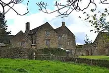
| Unthank Hall | Holmesfield | House | Earlier than late 16th century | 31 January 1967 | SK3070276072 53°16′51″N 1°32′28″W |
1057686 | .jpg.webp) Unthank Hall |
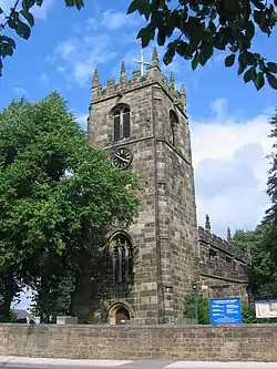
| Church of St Giles | Killamarsh | Church | 12th century | 7 July 1989 | SK4612080966 53°19′25″N 1°18′33″W |
1057656 | 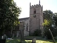 Church of St Giles |
| Church of Holy Cross | Morton | Church | Late 13th century | 31 January 1967 | SK4072560115 53°08′12″N 1°23′34″W |
1335461 | |
| Church of St Leonard | Shirland | Church | 15th century | 31 January 1967 | SK3997058458 53°07′18″N 1°24′15″W |
1158790 | |
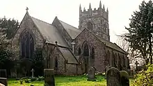
| Church of St Mary | Sutton-cum-Duckmanton | Church | Early 14th century | 31 January 1967 | SK4421268878 53°12′54″N 1°20′22″W |
1108915 | 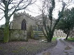 Church of St Mary |
| Unstone Manor House | Unstone | Manor house | 1630 | 25 October 1951 | SK3694777380 53°17′32″N 1°26′50″W |
1335126 | |
| West Handley Hall | Unstone | House | Early 17th century | 31 January 1967 | SK3983677536 53°17′36″N 1°24′14″W |
1335127 | |
| Stubbing Court | Wingerworth | Country house | Early–mid-18th century | 31 January 1967 | SK3570267145 53°12′01″N 1°28′01″W |
1291898 | .jpg.webp) Stubbing Court |
See also
- Grade I listed buildings in Derbyshire
- Grade II* listed buildings in Amber Valley
- Grade II* listed buildings in Bolsover (district)
- Grade II* listed buildings in Chesterfield
- Grade II* listed buildings in Derby
- Grade II* listed buildings in Derbyshire Dales
- Grade II* listed buildings in Erewash
- Grade II* listed buildings in High Peak
- Grade II* listed buildings in South Derbyshire
Notes
- The date given is the date used by Historic England as significant for the initial building or that of an important part in the structure's description.
- Sometimes known as OSGB36, the grid reference is based on the British national grid reference system used by the Ordnance Survey.
- The "List Entry Number" is a unique number assigned to each listed building and scheduled monument by Historic England.
External links
![]() Media related to Grade II* listed buildings in Derbyshire at Wikimedia Commons
Media related to Grade II* listed buildings in Derbyshire at Wikimedia Commons
This article is issued from Wikipedia. The text is licensed under Creative Commons - Attribution - Sharealike. Additional terms may apply for the media files.