Grade II* listed buildings in Derby
There are over 20,000 Grade II* listed buildings in England. This page is a list of these buildings in the City of Derby in Derbyshire.
List of buildings
| Name | Location | Type | Completed [note 1] | Date designated | Grid ref.[note 2] Geo-coordinates |
Entry number [note 3] | Image |
|---|---|---|---|---|---|---|---|
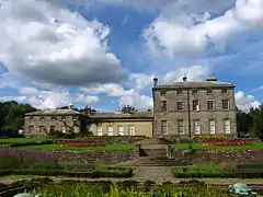
| Allestree Hall | Derby | House | 1802 | 13 February 1967 | SK3464440714 52°57′46″N 1°29′08″W |
1215234 | |
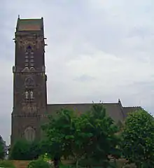
| Church of All Saints | Mickleover | Church | 14th century | 19 January 1967 | SK3052534203 52°54′16″N 1°32′51″W |
1216184 | .jpg.webp) Church of All Saints |
| Church of St Anne | Derby | Church | 1871 | 3 July 1998 | SK3442736941 52°55′44″N 1°29′22″W |
1334930 | 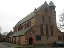 Church of St Anne |
| Church of St Edmund | Allestree | Church | 12th–13th century | 13 February 1967 | SK3479339714 52°57′13″N 1°29′01″W |
1228939 | 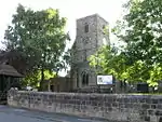 Church of St Edmund |
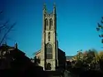
| Church of St John the Evangelist | Derby | Church | 1828 | 20 June 1952 | SK3451836612 52°55′33″N 1°29′17″W |
1215810 | .JPG.webp) Church of St John the Evangelist |
| Church of St Luke | Derby | Church | Late 19th century | 24 February 1977 | SK3432135626 52°55′01″N 1°29′28″W |
1279315 | |
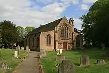
| Church of St Mary | Boulton | Church | 12th century | 10 November 1967 | SK3844033038 52°53′36″N 1°25′48″W |
1287987 | |
| Church of St Peter | Chellaston | Church | 15th century | 10 November 1967 | SK3811730378 52°52′10″N 1°26′07″W |
1227902 | 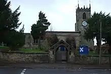 Church of St Peter |
| Church of St Peter and attached boundary walls | Derby | Church | Mid-/late 19th century | 20 June 1952 | SK3530836015 52°55′13″N 1°28′35″W |
1229224 | .JPG.webp) Church of St Peter and attached boundary walls |
| Church of St Werburgh | Derby | Church | 18th century | 20 June 1952 | SK3497936323 52°55′23″N 1°28′52″W |
1287685 | |
| College of Art Annexe | Derby | Art school | 1876 | 24 February 1977 | SK3519835846 52°55′08″N 1°28′41″W |
1227834 | .JPG.webp) College of Art Annexe |
| Darley Abbey Mills (north complex) North Mill and engine house and boiler house | Darley Abbey | Mill buildings | c. 1825 | 13 February 1967 | SK3540138634 52°56′38″N 1°28′29″W |
1067808 | 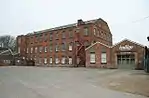 Darley Abbey Mills (north complex) North Mill and engine house and boiler house |
| Darley Abbey Mills (north complex) preparation building and cottage and workshop and cart sheds to north of site | Derby | Mill buildings | 1790s | 13 February 1967 | SK3537238676 52°56′40″N 1°28′30″W |
1067809 |  |
| Former carriage shop at Derby Railway Works | Derby | Railway works | 1840 | 21 February 1994 | SK3637935646 52°55′01″N 1°27′38″W |
1278575 | |
| Former engine shed (remains of the original Midland Region Railway Station) | Derby | Railway engineering workshop | c.1830 | 24 February 1977 | SK3636935593 52°55′00″N 1°27′38″W |
1228933 | 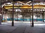 Former engine shed (remains of the original Midland Region Railway Station) |
| Former railway workshop at Derby Railway Works | Derby | Turning shop | 19th century | 24 February 1977 | SK3633335699 52°55′03″N 1°27′40″W |
1230740 | 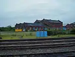 Former railway workshop at Derby Railway Works |
| Friary Hotel | Derby | Hotel | Mid-18th century | 20 June 1952 | SK3480336333 52°55′24″N 1°29′02″W |
1227747 | .JPG.webp) Friary Hotel |
| Green Man Inn | Derby | Public house | 17th century | 20 June 1952 | SK3531335984 52°55′12″N 1°28′34″W |
1229456 | 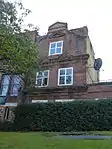 Green Man Inn |
| Midland Railway War Memorial | Derby | War memorial | 1921 | 24 February 1977 | SK3608635478 52°54′56″N 1°27′53″W |
1228742 | |
| Old Abbey Building | Darley Abbey | Augustinian monastery | 15th century | 13 February 1967 | SK3525738411 52°56′31″N 1°28′36″W |
1287744 | 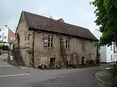 Old Abbey Building |
| Old Grammar School | Derby | Former school | 16th century | 20 June 1952 | SK3528136002 52°55′13″N 1°28′36″W |
1279098 | 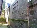 Old Grammar School |
| Old Hall | Mickleover | Timber-framed house | 1649 | 2 September 1952 | SK3052834024 52°54′10″N 1°32′51″W |
1279400 | 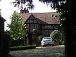 Old Hall |
| Pair of gateways leading to Spondon School (Upper House) and Adult Centre | Spondon | Gate | 18th century | 10 November 1967 | SK3962936096 52°55′15″N 1°24′43″W |
1279402 | |
| Roman Catholic Church of St Mary | Derby | Church | 1838 | 20 June 1952 | SK3511836792 52°55′39″N 1°28′45″W |
1215808 | |
| Rykneld Mill | Derby | Mill buildings | c. 1808 | 24 February 1977 | SK3474836699 52°55′36″N 1°29′04″W |
1215910 | 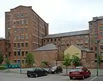 Rykneld Mill |
| Stone House Prebend | Derby | Farmhouse | Late 16th century | 20 June 1952 | SK3524937485 52°56′01″N 1°28′37″W |
1228772 | |
| St Mary's Bridge | Derby | Bridge | 18th century | 20 June 1952 | SK3538436766 52°55′38″N 1°28′30″W |
1215897 | 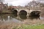 St Mary's Bridge |
| Wardwick Tavern Public House | Derby | Public house | Early 18th century | 20 June 1952 | SK3508936205 52°55′20″N 1°28′46″W |
1229898 | 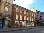 Wardwick Tavern Public House |
| 27 Friar Gate | Derby | House | Mid-18th century | 20 June 1952 | SK3474336396 52°55′26″N 1°29′05″W |
1216457 | 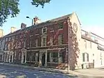 27 Friar Gate |
| 42 Friar Gate | Derby | House | Mid-18th century | 20 June 1952 | SK3464336464 52°55′28″N 1°29′10″W |
1216463 | 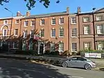 42 Friar Gate |
| 43–44 Friar Gate | Derby | House | Mid-18th century | 20 June 1952 | SK3462836458 52°55′28″N 1°29′11″W |
1216527 | 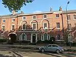 43–44 Friar Gate |
| 47–51 Friar Gate | Derby | Building | Late 18th century | 20 June 1952 | SK3459236480 52°55′29″N 1°29′13″W |
1287582 | .jpg.webp) 47–51 Friar Gate |
| 99 Friar Gate | Derby | House | Mid-18th century | 20 June 1952 | SK3470636374 52°55′25″N 1°29′07″W |
1216586 | 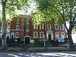 99 Friar Gate |
| 35–36 St Mary's Gate | Derby | Building | Early/mid-18th century | 20 June 1952 | SK3510436459 52°55′28″N 1°28′45″W |
1279144 | .JPG.webp) 35–36 St Mary's Gate |
| 1 and 2 Brick Row | Darley Abbey | Former school | 1826 | 13 February 1967 | SK3509338443 52°56′32″N 1°28′45″W |
1287988 | .jpg.webp) 1 and 2 Brick Row |
| 3–16 Brick Row | Darley Abbey | Workers' cottage | Late 18th or early 19th century | 24 February 1977 | SK3512038489 52°56′34″N 1°28′44″W |
1287923 | .jpg.webp) 3–16 Brick Row |
| 33 Wardwick | Derby | House | 17th century | 20 June 1952 | SK3504936229 52°55′20″N 1°28′48″W |
1278869 | 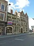 33 Wardwick |
| 48 Sadler Gate | Derby | Town house | 1675 | 20 June 1952 | SK3515936314 52°55′23″N 1°28′43″W |
1279059 | 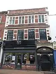 48 Sadler Gate |
.JPG.webp)
.jpg.webp)
See also
- Grade I listed buildings in Derbyshire
- Grade II* listed buildings in Derbyshire
- Grade II* listed buildings in Amber Valley
- Grade II* listed buildings in Bolsover (district)
- Grade II* listed buildings in Chesterfield
- Grade II* listed buildings in Derbyshire Dales
- Grade II* listed buildings in Erewash
- Grade II* listed buildings in High Peak
- Grade II* listed buildings in North East Derbyshire
- Grade II* listed buildings in South Derbyshire
Notes
- The date given is the date used by Historic England as significant for the initial building or that of an important part in the structure's description.
- Sometimes known as OSGB36, the grid reference is based on the British national grid reference system used by the Ordnance Survey.
- The "List Entry Number" is a unique number assigned to each listed building and scheduled monument by Historic England.
External links
![]() Media related to Grade II* listed buildings in Derbyshire at Wikimedia Commons
Media related to Grade II* listed buildings in Derbyshire at Wikimedia Commons
This article is issued from Wikipedia. The text is licensed under Creative Commons - Attribution - Sharealike. Additional terms may apply for the media files.
