Grade II* listed buildings in South Derbyshire
There are over 20,000 Grade II* listed buildings in England. This page is a list of these buildings in the district of South Derbyshire in Derbyshire.
List of buildings
| Name | Location | Type | Completed [note 1] | Date designated | Grid ref.[note 2] Geo-coordinates |
Entry number [note 3] | Image |
|---|---|---|---|---|---|---|---|
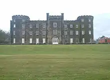
| Aston Hall | Aston-on-Trent | Country House | Early 18th century | 10 November 1967 | SK4149829170 52°51′30″N 1°23′06″W |
1096430 | |
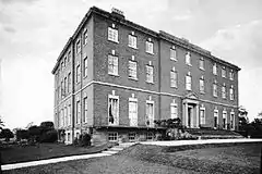
| Barton Hall | Barton Blount | Country House | 15th century | 2 September 1952 | SK2081934658 52°54′32″N 1°41′31″W |
1096544 |  |
| Bretby Hall | Bretby Park, Bretby | Country House | Early 17th century | 31 October 1985 | SK3001122547 52°47′59″N 1°33′23″W |
1334588 | |
| Brizlincote Hall Farmhouse | Bretby | Farmhouse | 1707 | 19 January 1967 | SK2727022027 52°47′42″N 1°35′49″W |
1096480 | 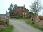 Brizlincote Hall Farmhouse |
| Deercote west of the Church of St Giles | Calke Park, Calke | Wall | Late 18th century | 6 January 1987 | SK3670922280 52°47′49″N 1°27′25″W |
1031806 | |
| Stables and Riding School | Calke Park, Calke | Courtyard | Mid–late 18th century | 19 January 1967 | SK3668322666 52°48′01″N 1°27′26″W |
1096488 | .jpg.webp) Stables and Riding School |
| Catton Hall | Catton | Country House | 1741 | 2 September 1952 | SK2061315359 52°44′08″N 1°41′46″W |
1334609 | |
| Cauldwell Hall | Cauldwell | Country House | Early 18th century | 2 September 1952 | SK2551417173 52°45′06″N 1°37′24″W |
1334612 | |
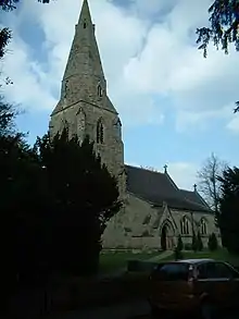
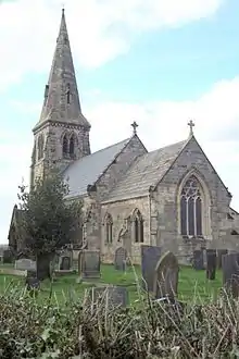
| Church of All Saints | Dalbury Lees | Parish Church | 13th century | 19 January 1967 | SK2635434282 52°54′19″N 1°36′35″W |
1334550 | |
| Footbridge on former Eggington Estate at SK264277 | Egginton | Footbridge | 1812 | 19 April 1990 | SK2640027700 52°50′46″N 1°36′34″W |
1140125 | |
| Elvaston Castle | Elvaston | Country House | 1633 | 2 September 1952 | SK4078533004 52°53′35″N 1°23′43″W |
1334604 | |
| Gates, gatepiers, and railings to south of the Etwall Almshouses | Etwall | Gate | Early 18th century | 22 August 1985 | SK2688232038 52°53′06″N 1°36′07″W |
1334552 | .jpg.webp) Gates, gatepiers, and railings to south of the Etwall Almshouses |
| Sir John Port Almshouses | Etwall | Almshouse | circa 1690 | 2 September 1952 | SK2687832064 52°53′07″N 1°36′07″W |
1096567 | .jpg.webp) Sir John Port Almshouses |
| Two sets of gatepiers and walls enclosing churchyard of St Saviours Church | Foremark | Gate | Early 18th century | 19 January 1967 | SK3297426488 52°50′06″N 1°30′43″W |
1334572 | 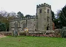 Two sets of gatepiers and walls enclosing churchyard of St Saviours Church |
| The Manor House | Hartshorne | House | 20th century | 2 September 1952 | SK3269020767 52°47′01″N 1°31′00″W |
1281804 | |
| Ingleby Toft | Ingleby | House | Early 18th century | 19 January 1967 | SK3550526504 52°50′06″N 1°28′28″W |
1370039 | .jpg.webp) Ingleby Toft |
| Church of All Saints | Lullington | Parish Church | Late 14th century | 19 January 1967 | SK2498712944 52°42′49″N 1°37′54″W |
1159003 | |
| Grotto to south-east of the Old Mill in Melbourne Hall gardens | Melbourne | Shell Grotto | Early 19th century | 10 November 1967 | SK3910424843 52°49′11″N 1°25′16″W |
1334617 | |
| Hall Cottages and Stables at Melbourne Hall | Melbourne | House | 16th century | 10 November 1967 | SK3894525025 52°49′17″N 1°25′25″W |
1096408 | |
| Melbourne Hall | Melbourne | Country House | circa 1630 | 2 September 1952 | SK3897625010 52°49′16″N 1°25′23″W |
1204079 | |
| Pair of curved benches to either side of Grand Basin in Melbourne Hall gardens | Melbourne | Garden Seat | Early 18th century | 11 March 1987 | SK3916424944 52°49′14″N 1°25′13″W |
1096373 | |
| Pair of garden walls flanking top terrace of Melbourne Hall gardens | Melbourne | Garden Wall | circa 1704 | 11 March 1987 | SK3903724949 52°49′14″N 1°25′20″W |
1096410 | |
| Tithe Barn | Melbourne | Malt Kiln | 17th century | 2 September 1952 | SK3887324981 52°49′15″N 1°25′29″W |
1204539 | |
| Water channel and three bridges in Melbourne Hall gardens | Melbourne | Bridge | Early 18th century | 11 March 1987 | SK3912624926 52°49′14″N 1°25′15″W |
1204519 | |
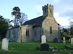
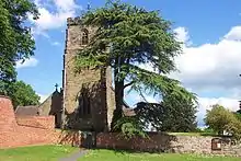
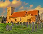
| Church of St Peter | Netherseal | Parish Church | 13th century | 10 January 1967 | SK2887712890 52°42′46″N 1°34′26″W |
1334597 | |
| Netherseal Old Hall and attached outbuildings and garden walls | Netherseal | House | 1642 | 2 September 1952 | SK2899712892 52°42′47″N 1°34′20″W |
1096414 | 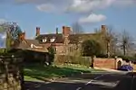 Netherseal Old Hall and attached outbuildings and garden walls |
| Pigeoncote at Old Hall Cottages | Netherseal | Dovecote | 1689 | 19 January 1967 | SK2898512819 52°42′44″N 1°34′21″W |
1096418 | |
| Bladon Castle | Newton Solney | Motte | 1801-2 | 19 January 1967 | SK2698925079 52°49′21″N 1°36′03″W |
1096466 | |
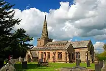
| Church of St Mary the Virgin | Newton Solney | Parish Church | circa 1300 | 19 January 1967 | SK2792425770 52°49′43″N 1°35′13″W |
1334576 | |
| Overseal House | Overseal | House | Late 18th century | 19 January 1967 | SK2963714953 52°43′53″N 1°33′45″W |
1311162 | .jpg.webp) Overseal House |
| The Grange | Repton | House | 1703 | 2 September 1952 | SK3069326437 52°50′04″N 1°32′45″W |
1096501 | |
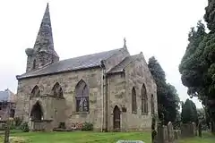
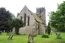
| Church of St Mary | Rosliston | Parish Church | 14th century | 19 January 1967 | SK2433716815 52°44′54″N 1°38′27″W |
1159242 | |
| Shardlow Hall with attached garden seat to north-east corner, steps c.14m from north-west front and steps c.7m west of south-west corner | Shardlow | Country House | 1684 | 11 March 1987 | SK4384830478 52°52′12″N 1°21′00″W |
1088368 | .jpg.webp) Shardlow Hall with attached garden seat to north-east corner, steps c.14m from north-west front and steps c.7m west of south-west corner |
| The Lock Up (Round House) | Smisby | Lock Up | Late 18th century | 19 January 1967 | SK3486919083 52°46′06″N 1°29′05″W |
1281737 | 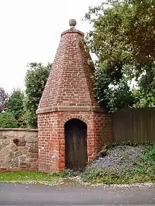 The Lock Up (Round House) |
| Church of St Michael | Sutton on the Hill | Statue | 20th century | 19 January 1967 | SK2374434239 52°54′18″N 1°38′54″W |
1096581 | |
| Sutton Hall and attached outbuildings | Sutton on the Hill | House | 1952 | 2 September 1952 | SK2363333815 52°54′05″N 1°39′00″W |
1334519 | |
| Church of St James | Swarkestone | Parish Church | 12th century | 10 November 1967 | SK3719628595 52°51′13″N 1°26′57″W |
1088344 | |
| Swarkestone Hall Farmhouse | Swarkestone | Farmhouse | Early 17th century | 2 September 1952 | SK3745528406 52°51′07″N 1°26′43″W |
1088346 | 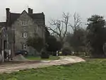 Swarkestone Hall Farmhouse |
| Swarkestone Old Hall and attached walls | Swarkestone | House | 18th century | 10 November 1967 | SK3734328500 52°51′10″N 1°26′49″W |
1280604 | |
| The Lock-up | Ticknall | Lock Up | Late 18th century | 19 January 1967 | SK3515323908 52°48′42″N 1°28′48″W |
1096445 | 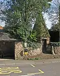 The Lock-up |
| The Middle Lodge | Calke Park, Ticknall | Gate Lodge | circa 1805 | 19 January 1967 | SK3573223168 52°48′18″N 1°28′17″W |
1203338 | 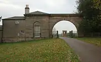 The Middle Lodge |
| All Saints Church | Trusley | Parish Church | 1713 | 19 January 1967 | SK2535735533 52°55′00″N 1°37′28″W |
1281370 | 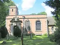 All Saints Church |
| Old Hall Cottage | Twyford | House | 16th century | 19 January 1967 | SK3291128928 52°51′25″N 1°30′46″W |
1096517 | .jpg.webp) Old Hall Cottage |
| Church of St Laurence | Walton-on-Trent | Statue | 20th century | 19 January 1967 | SK2158918230 52°45′40″N 1°40′53″W |
1159347 | |
| Walton Hall and attached stable range and garden wall | Walton-on-Trent | Country House | Early 18th century | 2 September 1952 | SK2145917882 52°45′29″N 1°41′00″W |
1159300 | 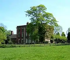 Walton Hall and attached stable range and garden wall |
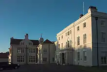
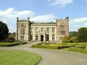
| Weston Hall | Weston-on-Trent | Country House | Early 17th century | 2 September 1952 | SK4032628350 52°51′04″N 1°24′09″W |
1088352 | 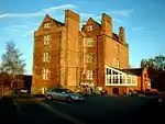 Weston Hall |
| Four bottle kilns at Greens Pottery | Church Gresley | Bottle kiln | 18th century | 29 October 1974 | SK3055818744 52°45′56″N 1°32′55″W |
1280950 | 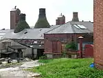 Four bottle kilns at Greens Pottery |
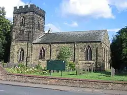
| Parish Church of St Mary and Saint George | Church Gresley | Church | 15th century | 14 October 1981 | SK2932718108 52°45′35″N 1°34′01″W |
1204963 |

See also
- Grade I listed buildings in Derbyshire
- Grade II* listed buildings in Amber Valley
- Grade II* listed buildings in Bolsover (district)
- Grade II* listed buildings in Chesterfield
- Grade II* listed buildings in Derby
- Grade II* listed buildings in Derbyshire Dales
- Grade II* listed buildings in Erewash
- Grade II* listed buildings in High Peak
- Grade II* listed buildings in North East Derbyshire
Notes
- The date given is the date used by Historic England as significant for the initial building or that of an important part in the structure's description.
- Sometimes known as OSGB36, the grid reference is based on the British national grid reference system used by the Ordnance Survey.
- The "List Entry Number" is a unique number assigned to each listed building and scheduled monument by Historic England.
External links
![]() Media related to Grade II* listed buildings in Derbyshire at Wikimedia Commons
Media related to Grade II* listed buildings in Derbyshire at Wikimedia Commons
This article is issued from Wikipedia. The text is licensed under Creative Commons - Attribution - Sharealike. Additional terms may apply for the media files.
