Grade II* listed buildings in Derbyshire Dales
There are over 20,000 Grade II* listed buildings in England. This page is a list of these buildings in the district of Derbyshire Dales in Derbyshire.
List of buildings
| Name | Location | Type | Completed [note 1] | Date designated | Grid ref.[note 2] Geo-coordinates |
Entry number [note 3] | Image |
|---|---|---|---|---|---|---|---|
| 37–39 St John's Street | Ashbourne | Town house | 18th century | 14 February 1974 | SK1813146787 53°01′05″N 1°43′52″W |
1335154 |  |
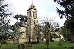
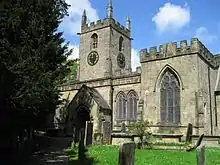
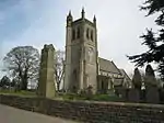
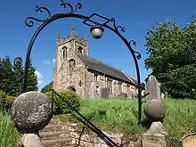
| Church of St John with street railings, gates, piers and front steps | Ashbourne | Church | 1871 | 14 February 1974 | SK1802346966 53°01′11″N 1°43′58″W |
1279720 | _Ashbourne%252C_Derbyshire.jpg.webp) Church of St John with street railings, gates, piers and front steps |
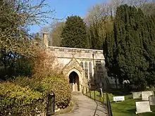
| Churchyard gate piers and gates to the parish church of St Oswald | Ashbourne | Gate | 18th century | 14 February 1974 | SK1767546490 53°00′56″N 1°44′17″W |
1109551 | 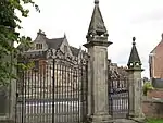 Churchyard gate piers and gates to the parish church of St Oswald |
| Dove House | Ashbourne | House | Early 18th century | 15 June 1951 | SK1787246774 53°01′05″N 1°44′06″W |
1109519 | |
| Owlfields Almshouses | Ashbourne | Almshouse | Shortly after 1640 | 15 June 1951 | SK1776446530 53°00′57″N 1°44′12″W |
1207678 |  Owlfields Almshouses |
| Pegg's Almshouses | Ashbourne | Almshouse | 1848 | 15 June 1951 | SK1779146539 53°00′57″N 1°44′11″W |
1109548 |  Pegg's Almshouses |
| Smiths Wine Tavern | Ashbourne | Shop | Late 18th/early 19th century | 15 June 1951 | SK1809146729 53°01′03″N 1°43′54″W |
1109503 | .jpg.webp) Smiths Wine Tavern |
| Summerhouse in grounds of Mansion House | Ashbourne | Summerhouse | Mid-18th century | 15 June 1951 | SK1776646498 53°00′56″N 1°44′12″W |
1109549 | |
| The Green Man and Black's Head Hotel, attached inn sign bridging road | Ashbourne | Inn sign | Mid-18th century | 15 June 1951 | SK1802646674 53°01′01″N 1°43′58″W |
1293246 | 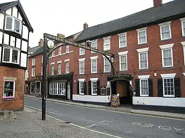 The Green Man and Black's Head Hotel, attached inn sign bridging road |
| The Grey House | Ashbourne | House | 1760–70 | 15 June 1951 | SK1773546547 53°00′57″N 1°44′14″W |
1109543 | 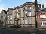 The Grey House |
| 20 and 22, Market Place | Ashbourne | House | Late 17th/early 18th century | 15 June 1951 | SK1806046814 53°01′06″N 1°43′56″W |
1208191 | 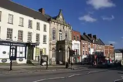 20 and 22, Market Place |
| Ashford Hall | Ashford-in-the-Water | Country house | c. 1785 | 12 July 1967 | SK1996469772 53°13′29″N 1°42′09″W |
1109281 |  Ashford Hall |
| Sheepwash Bridge | Ashford-in-the-Water | Bridge | 18th century | 12 July 1967 | SK1943169612 53°13′24″N 1°42′38″W |
1335270 | 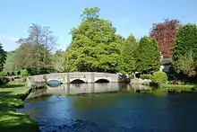 Sheepwash Bridge |
| Bagshaw Hall | Bakewell | Townhouse | 1684 | 13 March 1951 | SK2161868637 53°12′52″N 1°40′40″W |
1147985 | 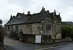 Bagshaw Hall |
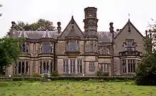
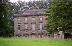
| Burton Closes | Bakewell | Country house | c.1845–48 | 13 March 1951 | SK2205467664 53°12′20″N 1°40′17″W |
1148032 | |
| Old House Museum including mounting block | Bakewell | House | c.16th and 17th century | 20 April 1954 | SK2147868541 53°12′49″N 1°40′47″W |
1247512 | _-_geograph.org.uk_-_1726471.jpg.webp) Old House Museum including mounting block |
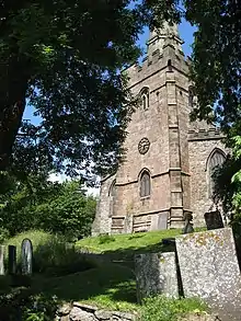
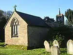
| Church of St Anne | Baslow and Bubnell | Church | 13th century | 12 July 1967 | SK2518072331 53°14′51″N 1°37′27″W |
1088200 | |
| Beeley Hilltop House | Beeley | Manor house | Early 17th century | 12 July 1967 | SK2694068412 53°12′44″N 1°35′53″W |
1088204 | 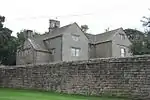 Beeley Hilltop House |
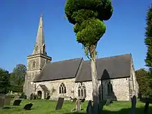
| Church of St Anne | Beeley | Church | 12th century | 12 July 1967 | SK2648867646 53°12′19″N 1°36′18″W |
1063739 | 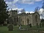 Church of St Anne |
| Old Hall, attached walls and doorway | Beeley | Manor house | Early 17th century | 12 July 1967 | SK2666267561 53°12′16″N 1°36′08″W |
1356550 | |
| Green House and attached garden walls and gate piers | Birchover | House | 1774 | 12 July 1967 | SK2377462084 53°09′19″N 1°38′45″W |
1109893 | |
| Market Cross | Bonsall | Cross | Late 14th century | 22 June 1950 | SK2791858292 53°07′16″N 1°35′03″W |
1248285 | 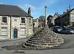 Market Cross |
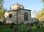
| Parish Church of St James | Bonsall | Church | 13th–14th century | 22 June 1950 | SK2798758133 53°07′11″N 1°35′00″W |
1263911 | |
| Church of St John the Baptist | Boylestone | Church | Early 14th century | 13 September 1967 | SK1816335825 52°55′10″N 1°43′53″W |
1109778 | |
| Bradbourne Hall | Bradbourne | House | Late 16th/early 17th century | 11 October 1983 | SK2084652751 53°04′18″N 1°41′25″W |
1109477 | |
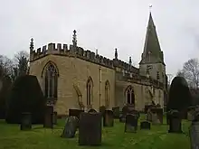
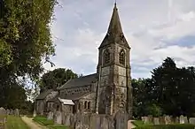
| Church of All Saints | Bradley | Church | Late 14th century and earlier | 13 September 1967 | SK2234145970 53°00′38″N 1°40′07″W |
1109352 | 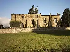 Church of All Saints |
| Church of St James | Brassington | Church | 14th century | 13 September 1967 | SK2302654325 53°05′08″N 1°39′28″W |
1109483 | 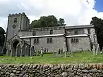 Church of St James |
| The Gate Inn | Brassington | House | 1616 | 13 September 1967 | SK2298454209 53°05′05″N 1°39′30″W |
1109450 | 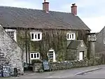 The Gate Inn |
| Callow Hall | Callow | Farmhouse | 17th century | 11 October 1983 | SK2688751800 53°03′46″N 1°36′01″W |
1111886 | 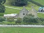 Callow Hall |
| Calver Bridge | Calver | Road bridge | c.1800 | 12 July 1967 | SK2463474422 53°15′58″N 1°37′56″W |
1088212 | 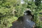 Calver Bridge |
| Church of St Margaret | Carsington | Church | 1648 | 13 September 1967 | SK2524253429 53°04′39″N 1°37′29″W |
1109458 | |
| Queen Mary's Bower | Chatsworth | Viewing platform | 16th century | 12 July 1967 | SK2575870306 53°13′45″N 1°36′56″W |
1334745 | 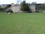 Queen Mary's Bower |
| The First Duke's Greenhouse | Chatsworth Gardens, Chatsworth | Glasshouse | 1697 98 | 12 July 1967 | SK2614370174 53°13′41″N 1°36′35″W |
1334741 | 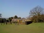 The First Duke's Greenhouse |
| The Hunting Tower | Chatsworth | Hunting tower | c.1582 | 12 July 1967 | SK2650070628 53°13′55″N 1°36′16″W |
1372877 | 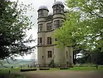 The Hunting Tower |
| Church of St John the Baptist | Chelmorton | Church | 13th century | 12 July 1967 | SK1155570262 53°13′45″N 1°49′42″W |
1109264 | 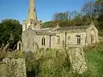 Church of St John the Baptist |
| Hanging Bridge and attached retaining walls to road (that part in Ashbourne Road) | Clifton and Compton | Road bridge | 14th century | 12 January 1966 | SK1583145802 53°00′33″N 1°45′56″W |
1109712 | 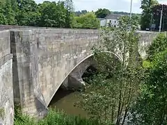 Hanging Bridge and attached retaining walls to road (that part in Ashbourne Road) |
| Bridge House | Cromford | House | Early 17th century | 22 June 1950 | SK3005557271 53°06′42″N 1°33′09″W |
1247939 |  Bridge House |
| Cromford Bridge (over River Derwent) | Cromford | Road bridge | 15th century | 22 June 1950 | SK3001457180 53°06′39″N 1°33′11″W |
1263846 |  Cromford Bridge (over River Derwent) |
| Greyhound Hotel | Cromford | Inn | Mid-18th century | 22 June 1950 | SK2950856922 53°06′31″N 1°33′38″W |
1248007 |  Greyhound Hotel |
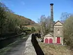
| High Peak Pump House (Leawood Pump House) | High Peak Junction, Cromford | Pumphouse | Early 19th century | 26 October 1972 | SK3152855682 53°05′51″N 1°31′50″W |
1247889 | |
| The Arkwright Houses | Cromford | House | 1776 77 | 21 January 1964 | SK2944656735 53°06′25″N 1°33′42″W |
1248131 | _Geograph-3397136-by-Graham-Horn.jpg.webp) The Arkwright Houses |
| The Arkwright Houses and unnumbered house to left of Number 1 | Cromford | House | 1776 77 | 21 January 1964 | SK2946656749 53°06′26″N 1°33′41″W |
1263811 | 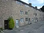 The Arkwright Houses and unnumbered house to left of Number 1 |
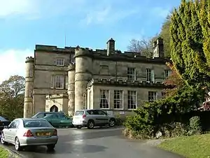
| Willersley Castle | Cromford | Country house | 1792 | 22 June 1950 | SK2964857226 53°06′41″N 1°33′31″W |
1248280 | |
| Darley Bridge (over River Derwent) | Darley Bridge, Darley Dale | Road bridge | 15th century | 22 June 1950 | SK2705262076 53°09′18″N 1°35′49″W |
1248041 |  Darley Bridge (over River Derwent) |
| Holt House | Darley Dale | House | Late 18th century | 22 June 1950 | SK2839662758 53°09′40″N 1°34′36″W |
1263879 | |
| Parish Church of St Helen | Darley Dale | Church | Norman to Perpendicular | 22 June 1950 | SK2667662984 53°09′48″N 1°36′09″W |
1247836 | |
| Home Farmhouse | West Broughton, Doveridge | Farmhouse | 16th century | 13 September 1967 | SK1466532634 52°53′27″N 1°47′01″W |
1274524 | |
| Lowerstreet Farmhouse | Doveridge | Farmhouse | Early 16th century | 13 September 1967 | SK1183233735 52°54′03″N 1°49′32″W |
1237735 |  Lowerstreet Farmhouse |
| Manor House | Doveridge | House | Early 18th century | 13 September 1967 | SK1221833872 52°54′08″N 1°49′11″W |
1238121 | .jpg.webp) Manor House |
| Castle Lodge and attached railings | Edensor | Gate lodge | 1842 | 12 July 1967 | SK2510870004 53°13′35″N 1°37′31″W |
1088160 | 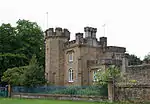 Castle Lodge and attached railings |
| Chatsworth Estate Office and Village Institute | Edensor | Hotel | c.1776–77 | 12 July 1967 | SK2501370208 53°13′42″N 1°37′36″W |
1054089 | .jpg.webp) Chatsworth Estate Office and Village Institute |
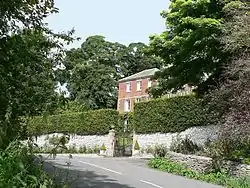
| House west of Park View occupied by Mr Hubbuck | Edensor | House | c.1830–40 | 12 July 1967 | SK2514269943 53°13′33″N 1°37′30″W |
1088157 | 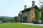 House west of Park View occupied by Mr Hubbuck |
| Norman Villa and attached garden walls | Edensor | House | c.1830–40 | 12 July 1967 | SK2498869908 53°13′32″N 1°37′38″W |
1334748 | 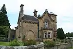 Norman Villa and attached garden walls |
| One Arch Bridge | Edensor | Road bridge | 1759–60 | 12 July 1967 | SK2607168441 53°12′45″N 1°36′40″W |
1052356 | 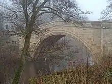 One Arch Bridge |
| Tudor Lodge | Edensor | House | 1837–39 | 12 July 1967 | SK2501970102 53°13′39″N 1°37′36″W |
1334736 |  Tudor Lodge |
| Church of St James | Edlaston | Church | Early 14th century | 13 September 1967 | SK1811842674 52°58′52″N 1°43′54″W |
1158423 | |
| Church of St Lawrence | Eyam | Church | 1775 | 12 July 1967 | SK2177476417 53°17′03″N 1°40′30″W |
1110019 | |
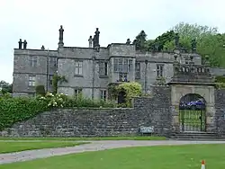
| Eyam Hall | Eyam | Country house | Early 17th century | 29 September 1951 | SK2164076493 53°17′06″N 1°40′37″W |
1334913 | |
| Cherry Orchard Farmhouse and attached outbuildings | Fenny Bentley | Farmhouse | Late 17th century | 5 February 1952 | SK1760050181 53°02′55″N 1°44′20″W |
1109314 | 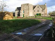 Cherry Orchard Farmhouse and attached outbuildings |
| Church of St Edmund | Fenny Bentley | Church | c.1300 | 13 September 1967 | SK1745750189 53°02′55″N 1°44′28″W |
1335262 | |
| Flagg Hall | Flagg | Farmhouse | 17th century | 27 July 1984 | SK1376968484 53°12′48″N 1°47′43″W |
1109266 | |
| Old Farmhouse, Town Head Farm | Flagg | Farmhouse | 1639 | 27 July 1984 | SK1288969017 53°13′05″N 1°48′30″W |
1109265 | 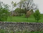 Old Farmhouse, Town Head Farm |
| The Hall | Great Longstone | Country house | 17th century | 29 September 1951 | SK1985571954 53°14′39″N 1°42′14″W |
1109904 | |
| Stoke Hall | Grindleford | Country house | 1757 | 8 August 1985 | SK2402776138 53°16′54″N 1°38′28″W |
1158686 | |
| Biggin Hall | Biggin | House | c.1642 | 10 August 1951 | SK1517259570 53°07′59″N 1°46′29″W |
1087837 | |
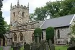
| Church of St Giles | Hartington | Church | Late 13th century | 10 August 1951 | SK1296160478 53°08′29″N 1°48′28″W |
1087851 | 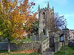 Church of St Giles |
| Hassop Hall | Hassop | Country house | 17th century | 29 September 1951 | SK2219572216 53°14′47″N 1°40′08″W |
1088171 | |
| Hathersage Hall | Hathersage | Country house | 1496 | 29 September 1951 | SK2334981670 53°19′53″N 1°39′03″W |
1109807 | |
| Roman Catholic Church of St Michael | Hathersage | Church | Early 18th century | 12 July 1967 | SK2295281602 53°19′51″N 1°39′25″W |
1109804 | 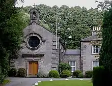 Roman Catholic Church of St Michael |
| Hazelbadge Hall | Bradwell | House | 1549 | 29 September 1951 | SK1716879998 53°19′00″N 1°44′38″W |
1356169 |  Hazelbadge Hall |
| Gateway to Highlow Hall | Hathersage | Gate | Early 17th century | 12 July 1967 | SK2189180111 53°19′03″N 1°40′22″W |
1334994 | 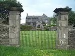 Gateway to Highlow Hall |
| Highlow Hall | Hathersage | Manor house | Late 16th century | 29 September 1951 | SK2191280096 53°19′02″N 1°40′21″W |
1311217 | |
| Church of St Bartholomew | Hognaston | Church | 12th century | 13 September 1967 | SK2352250585 53°03′07″N 1°39′02″W |
1138313 | 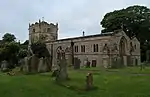 Church of St Bartholomew |
| Bentley Hall | Hungry Bentley | House | Early 17th century | 13 June 1967 | SK1776038102 52°56′24″N 1°44′14″W |
1335022 | |
| The Barley Mow Inn | Kirk Ireton | Inn | c.1600 | 20 October 1983 | SK2662950136 53°02′52″N 1°36′15″W |
1335227 | 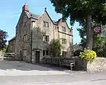 The Barley Mow Inn |
| Horsley Farmhouse | Kniveton | Farmhouse | Mid-18th century | 13 September 1967 | SK1990551572 53°03′40″N 1°42′16″W |
1146373 | |
| The Manor House | Little Hucklow | House | 1661 | 12 July 1967 | SK1642978565 53°18′14″N 1°45′18″W |
1334904 | 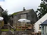 The Manor House |
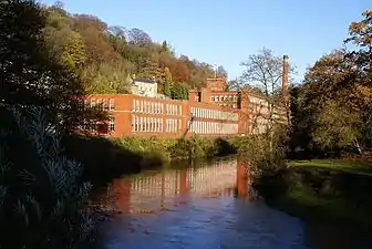
| Cressbrook Mill | Litton | Cotton mill | 1779 | 12 July 1967 | SK1729972709 53°15′04″N 1°44′32″W |
1158897 | 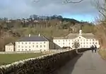 Cressbrook Mill |
| Barn at Longford Hall Farm | Longford | Barn | 1760 | 13 June 1967 | SK2149838432 52°56′34″N 1°40′54″W |
1109788 | |
| Gates and gatepiers to east of Longford Hall | Longford | Gates | Early 18th century | 19 July 1985 | SK2159438250 52°56′28″N 1°40′48″W |
1204005 | 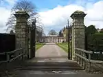 Gates and gatepiers to east of Longford Hall |
| Longford Hall and attached garden wall | Longford | Country house | Late 16th century | 13 June 1967 | SK2150538249 52°56′28″N 1°40′53″W |
1109787 | 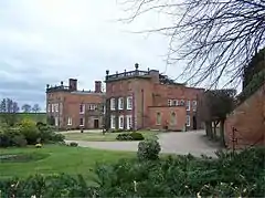 Longford Hall and attached garden wall |
| Stable block and coach house at Longford Hall Farm | Longford | Stable | Early 19th century | 13 June 1967 | SK2147438372 52°56′32″N 1°40′55″W |
1281396 | 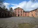 Stable block and coach house at Longford Hall Farm |
| Church of St Mary | Mapleton | Church | Mid-18th century | 13 September 1967 | SK1659348039 53°01′46″N 1°45′15″W |
1335265 | 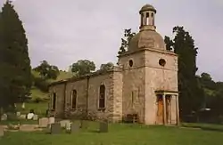 Church of St Mary |
| Manor House | Mapleton | House | Early 18th century | 13 September 1967 | SK1633047428 53°01′26″N 1°45′29″W |
1109317 | 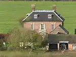 Manor House |
| Okeover Almshouses | Mapleton | Almshouses | 1727–30 | 13 September 1967 | SK1649048097 53°01′48″N 1°45′20″W |
1203564 | 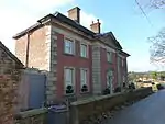 Okeover Almshouses |
| Church of St Giles | Marston Montgomery | Church | 12th century | 13 September 1967 | SK1349437888 52°56′18″N 1°48′02″W |
1204368 | 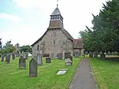 Church of St Giles |
| The Manor House | Marston Montgomery | House | Late 17th century | 5 February 1952 | SK1339537840 52°56′16″N 1°48′08″W |
1109755 | 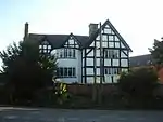 The Manor House |
| Dale Cottage | Matlock Bath | House | 1820 | 22 June 1950 | SK2955659464 53°07′53″N 1°33′35″W |
1247891 |  Dale Cottage |
| Masson Mills | Cromford | Cotton mill | c.1783 | 13 July 1955 | SK2942657348 53°06′45″N 1°33′43″W |
1247935 | |
| Chapel of St John the Baptist, supporting retaining wall and attached boundary walls | Matlock Bath | Chapel | 1897 | 26 October 1972 | SK2942659416 53°07′52″N 1°33′42″W |
1248139 | 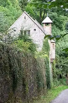 Chapel of St John the Baptist, supporting retaining wall and attached boundary walls |
| Church of St Giles | Matlock | Church | 15th century | 22 June 1950 | SK3008359769 53°08′03″N 1°33′07″W |
1247838 | |
| Riber Manor | Riber | House | 1633 | 22 June 1950 | SK3095959094 53°07′41″N 1°32′20″W |
1278030 | 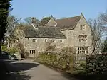 Riber Manor |
| Matlock Bridge (over River Derwent) | Matlock | Bridge | 15th century | 22 June 1950 | SK2978460174 53°08′16″N 1°33′22″W |
1247890 | 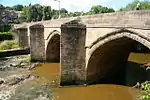 Matlock Bridge (over River Derwent) |
| Riber Hall | Riber | House | Early 17th century | 22 June 1950 | SK3087258977 53°07′37″N 1°32′24″W |
1278020 | 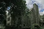 Riber Hall |
| St Andrew's House | The Cliff, Matlock | House | Mid-18th century | 5 September 1972 | SK3082759916 53°08′08″N 1°32′26″W |
1247886 | |
| Wheatsheaf Farmhouse | Matlock | Farmhouse | 1681 | 22 June 1950 | SK3002359709 53°08′01″N 1°33′10″W |
1247840 | |
| Church of St Leonard | Monyash | Church | Early 13th century | 12 July 1967 | SK1514466473 53°11′42″N 1°46′29″W |
1087822 | 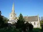 Church of St Leonard |
| Garden terraces and steps to south east of Haddon Hall | Haddon Hall | Steps | Mid-18th century | 12 July 1967 | SK2354966366 53°11′38″N 1°38′56″W |
1158083 | 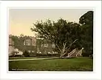 Garden terraces and steps to south east of Haddon Hall |
| Offerton Hall | Offerton | Manor house | 16th century | 29 September 1951 | SK2139681051 53°19′33″N 1°40′49″W |
1109771 | 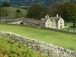 Offerton Hall |
| Church of St Martin | Osmaston | Church | 1845 | 13 September 1967 | SK1994744011 52°59′35″N 1°42′15″W |
1335071 | |
| North Lees Hall | Hathersage | House | Late 16th century | 29 September 1951 | SK2353983451 53°20′51″N 1°38′52″W |
1109774 | 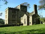 North Lees Hall |
| Church of St Peter | Parwich | Church | 12th century | 14 June 1984 | SK1883454351 53°05′10″N 1°43′13″W |
1109332 | |
| Parwich Hall | Parwich | House | Before c.1747 | 5 February 1952 | SK1863854606 53°05′18″N 1°43′23″W |
1281585 | |
| Caudwell's Mill | Rowsley | Feed mill | 1874 | 2 December 1977 | SK2557365743 53°11′17″N 1°37′07″W |
1088147 | 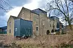 Caudwell's Mill |
| Rowsley Bridge (over River Derwent) | Little Rowsley, Rowsley | Bridge | 15th century | 22 June 1950 | SK2567365898 53°11′22″N 1°37′02″W |
1263843 |  Rowsley Bridge (over River Derwent) |
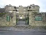
| The Peacock Hotel | Rowsley | Hotel | 1652 | 29 September 1951 | SK2560065867 53°11′21″N 1°37′06″W |
1045804 | 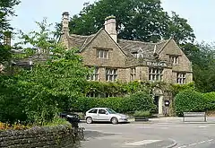 The Peacock Hotel |
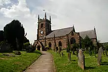
| Church of St Michael | Shirley | Church | 14th century | 13 September 1967 | SK2188741656 52°58′19″N 1°40′32″W |
1109692 | |
| Saw Mill (Osmaston Mill) | Shirley | Sawmill | c.1845 | 12 July 1985 | SK2074242826 52°58′57″N 1°41′33″W |
1109698 | 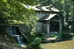 Saw Mill (Osmaston Mill) |
| Church of St Peter | Snelston | Church | 15th century | 13 September 1967 | SK1554043332 52°59′14″N 1°46′12″W |
1109768 | |
| Montgomery House | Somersal Herbert | House | Early 17th century | 13 September 1967 | SK1392135177 52°54′50″N 1°47′40″W |
1238456 | |
| Holly House | Stanton in Peak | House | Late 17th century | 12 July 1967 | SK2404964331 53°10′32″N 1°38′30″W |
1334986 | 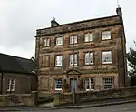 Holly House |
| Stanton Hall | Stanton in Peak | House | Early 18th century | 12 July 1967 | SK2409464164 53°10′27″N 1°38′28″W |
1158182 | |
| The Manor House, Stanton Woodhouse | Stanton in Peak | Country house | 16th century | 12 July 1967 | SK2561864285 53°10′30″N 1°37′05″W |
1311580 | |
| Church of St Martin | Stoney Middleton | Church | 15th century | 12 July 1967 | SK2316875479 53°16′33″N 1°39′15″W |
1109973 | |
| Church of All Saints | Sudbury | Church | 12th century | 13 September 1967 | SK1576832174 52°53′12″N 1°46′02″W |
1273942 | 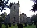 Church of All Saints |
| Folly or deercote in Park | Sudbury | Hunting lodge | Mid-18th century | 13 September 1967 | SK1622532729 52°53′30″N 1°45′37″W |
1238617 | 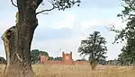 Folly or deercote in Park |
| South Viaduct | Millers Dale, Taddington | Railway viaduct | 1862–63 | 4 October 1985 | SK1395673215 53°15′21″N 1°47′32″W |
1087894 | 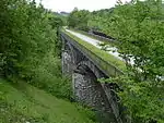 South Viaduct |
| Knoll House | Tansley | House | 1788 | 5 September 1969 | SK3217260139 53°08′15″N 1°31′14″W |
1247942 | |
| Church of St Mary | Tissington | Church | 12th century | 13 September 1967 | SK1764852276 53°04′03″N 1°44′17″W |
1109271 | |
| Tissington Hall | Tissington | House | Early 17th century | 5 February 1952 | SK1746352347 53°04′05″N 1°44′27″W |
1335283 | |
| Wheston Cross | Wheston | Cross | 15th century | 12 July 1967 | SK1319476438 53°17′05″N 1°48′13″W |
1215269 | 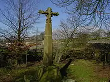 Wheston Cross |
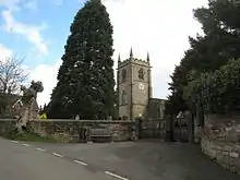
| The Market Hall | Winster | Market hall | 16th century | 29 September 1951 | SK2414860550 53°08′30″N 1°38′26″W |
1245115 | 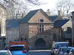 The Market Hall |
| Winster Hall | Winster | Country house | Early 18th century | 29 September 1951 | SK2412060586 53°08′31″N 1°38′27″W |
1109367 | 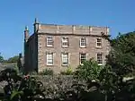 Winster Hall |
| Babington House | Wirksworth | House | c.1630 | 24 October 1950 | SK2860254132 53°05′01″N 1°34′28″W |
1335118 | |
| Grammar School | Wirksworth | School | 1828 | 24 October 1950 | SK2878553969 53°04′56″N 1°34′18″W |
1109616 | 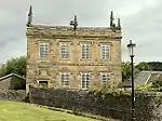 Grammar School |
| Haarlem Mill | Wirksworth | Mill | 18th century | 23 January 1973 | SK2837252573 49°46′01″N 7°33′26″W |
1335116 | 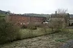 Haarlem Mill |
| Old Manor House | Wirksworth | House | Early 17th century | 23 January 1973 | SK2885454021 53°04′57″N 1°34′14″W |
1335096 | |
| Red Lion Hotel | Wirksworth | Hotel | Mid-18th century | 24 October 1950 | SK2867354046 53°04′58″N 1°34′24″W |
1112540 | .jpg.webp) Red Lion Hotel |
| The Gate House | Wirksworth | House | Early 17th century | 24 October 1950 | SK2854653866 53°04′53″N 1°34′31″W |
1109609 | |
| Wigwell Grange | Wirksworth | House | Regency | 24 October 1950 | SK3063454385 53°05′09″N 1°32′39″W |
1109565 |  Wigwell Grange |
| 1 Coldwell Street | Wirksworth | House | Late 18th century | 24 October 1950 | SK2869054041 53°04′58″N 1°34′23″W |
1335095 | 1 Coldwell Street |
| 15 Market Place | Wirksworth | House | Mid-18th century | 24 October 1950 | SK2864754041 53°04′58″N 1°34′26″W |
1109590 | 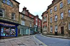 15 Market Place |
| Stydd Hall and attached garden wall | Yeaveley | Farmhouse | c.1840 | 5 February 1952 | SK1720040019 52°57′26″N 1°44′43″W |
1204898 |  Stydd Hall and attached garden wall |
| Old Hall Farmhouse | Youlgreave | Farmhouse | 1630 | 12 July 1967 | SK2096164303 53°10′32″N 1°41′16″W |
1335002 | 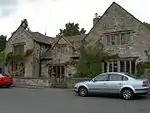 Old Hall Farmhouse |
| Matlock Bath War Memorial | Matlock Bath | War memorial | 1921 | 12 February 2018 | SK2960758373 53°07′18″N 1°33′33″W |
1451237 | .jpg.webp) Matlock Bath War Memorial |

.jpg.webp)

See also
- Grade I listed buildings in Derbyshire
- Grade II* listed buildings in Derbyshire
- Grade II* listed buildings in Amber Valley
- Grade II* listed buildings in Bolsover (district)
- Grade II* listed buildings in Chesterfield
- Grade II* listed buildings in Derby
- Grade II* listed buildings in Erewash
- Grade II* listed buildings in High Peak
- Grade II* listed buildings in North East Derbyshire
- Grade II* listed buildings in South Derbyshire
Notes
- The date given is the date used by Historic England as significant for the initial building or that of an important part in the structure's description.
- Sometimes known as OSGB36, the grid reference is based on the British national grid reference system used by the Ordnance Survey.
- The "List Entry Number" is a unique number assigned to each listed building and scheduled monument by Historic England.
External links
![]() Media related to Grade II* listed buildings in Derbyshire at Wikimedia Commons
Media related to Grade II* listed buildings in Derbyshire at Wikimedia Commons
This article is issued from Wikipedia. The text is licensed under Creative Commons - Attribution - Sharealike. Additional terms may apply for the media files.
