National Register of Historic Places listings in Atoka County, Oklahoma
This is a list of the National Register of Historic Places listings in Atoka County, Oklahoma.
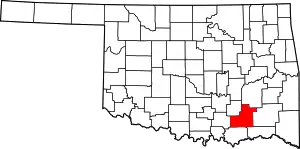
Location of Atoka County in Oklahoma
This is intended to be a complete list of the properties on the National Register of Historic Places in Atoka County, Oklahoma, United States. The locations of National Register properties for which the latitude and longitude coordinates are included below, may be seen in a map.[1]
There are 16 properties listed on the National Register in the county. Another 4 properties were once listed but have since been removed.
- This National Park Service list is complete through NPS recent listings posted January 29, 2021.[2]
Current listings
| [3] | Name on the Register[4] | Image | Date listed[5] | Location | City or town | Description |
|---|---|---|---|---|---|---|
| 1 | Atoka Armory |  Atoka Armory |
September 8, 1988 (#88001372) |
Ohio and C Sts. 34°23′17″N 96°07′22″W |
Atoka | |
| 2 | Isaac Billy Homestead and Family Cemetery | April 17, 1980 (#80003256) |
Northeast of Daisy 34°32′45″N 95°41′44″W |
Daisy | ||
| 3 | Boggy Depot Site | April 19, 1972 (#72001050) |
14 miles southwest of Atoka 34°19′13″N 96°18′51″W |
Atoka | ||
| 4 | Dunbar School |  Dunbar School |
June 14, 2016 (#16000369) |
NE. corner of OK 3 and S. Dunbar St. 34°22′30″N 96°07′34″W |
Atoka | |
| 5 | First Methodist Church Building |  First Methodist Church Building |
June 30, 1980 (#80003250) |
105 W. 1st St. 34°23′06″N 96°07′40″W |
Atoka | |
| 6 | First Oil Well in Oklahoma | April 13, 1972 (#72001053) |
4 miles northeast of Wapanucka 34°24′06″N 96°22′25″W |
Wapanucka | ||
| 7 | First Presbyterian Church | September 6, 2007 (#07000914) |
212 E. 1st St. 34°23′02″N 96°07′35″W |
Atoka | Demolished or moved | |
| 8 | Indian Citizen Building | October 4, 1979 (#79001984) |
115 N. Ohio Ave. 34°23′08″N 96°07′28″W |
Atoka | ||
| 9 | Capt. Charles LeFlore House | June 13, 1972 (#72001052) |
0.5 miles north of Limestone Gap on U.S. Route 69 34°36′17″N 95°58′33″W |
Limestone Gap | ||
| 10 | Masonic Temple | 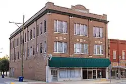 Masonic Temple |
September 8, 1980 (#80003251) |
301 Court St. 34°23′07″N 96°07′29″W |
Atoka | |
| 11 | Bo McAlister Site | April 21, 1978 (#78002217) |
Address Restricted |
Wapanucka | An archaeological site | |
| 12 | Middle Boggy Battlefield Site and Confederate Cemetery | April 19, 1972 (#72001051) |
1 mile north of Atoka 34°23′55″N 96°06′58″W |
Atoka | ||
| 13 | Old Atoka State Bank |  Old Atoka State Bank |
August 29, 1980 (#80003252) |
Court and Ohio Sts. 34°23′06″N 96°07′29″W |
Atoka | |
| 14 | Pioneer Club |  Pioneer Club |
June 27, 1980 (#80003253) |
1st and Mississippi Sts. 34°23′04″N 96°07′42″W |
Atoka | |
| 15 | Joe Ralls House |  Joe Ralls House |
June 27, 1980 (#80003254) |
303 S. Pennsylvania St. 34°22′58″N 96°07′32″W |
Atoka | |
| 16 | Waddell's Station Site | April 13, 1972 (#72001054) |
About 3 miles southwest of Wesley 34°34′01″N 95°56′02″W |
Wesley |
Former listings
| [3] | Name on the Register | Image | Date listed | Date removed | Location | City or town | Summary |
|---|---|---|---|---|---|---|---|
| 1 | Atoka Community Building | September 8, 1988 (#88001373) | December 29, 2005 | First and Delaware Streets |
Atoka | ||
| 2 | Old Atoka County Courthouse | December 6, 1979 (#79001985) | December 29, 2005 | Pennsylvania and Court Streets |
Atoka | ||
| 3 | Captain James S. Standley House | December 11, 1979 (#79001986) | December 29, 2005 | 207 N. Ohio Avenue |
Atoka | ||
| 4 | Zweigel Hardware Store Building | September 8, 1980 (#80003255) | December 29, 2005 | 405 and 407 Court Street |
Atoka |
See also
| Wikimedia Commons has media related to National Register of Historic Places in Atoka County, Oklahoma. |
References
- The latitude and longitude information provided in this table was derived originally from the National Register Information System, which has been found to be fairly accurate for about 99% of listings. Some locations in this table may have been corrected to current GPS standards.
- "National Register of Historic Places: Weekly List Actions". National Park Service, United States Department of the Interior. Retrieved on January 29, 2021.
- Numbers represent an alphabetical ordering by significant words. Various colorings, defined here, differentiate National Historic Landmarks and historic districts from other NRHP buildings, structures, sites or objects.
- "National Register Information System". National Register of Historic Places. National Park Service. March 13, 2009.
- The eight-digit number below each date is the number assigned to each location in the National Register Information System database, which can be viewed by clicking the number.
| Topics | |
|---|---|
| Lists by state |
|
| Lists by insular areas | |
| Lists by associated state | |
| Other areas | |
| Related | |
| |
| Atoka |
| |
|---|---|---|
| Daisy |
| |
| Limestone Gap |
| |
| Wapanucka |
| |
| Wesley | ||
This article is issued from Wikipedia. The text is licensed under Creative Commons - Attribution - Sharealike. Additional terms may apply for the media files.