National Register of Historic Places listings in Latimer County, Oklahoma
This is a list of the National Register of Historic Places listings in Latimer County, Oklahoma.
Location of Latimer County in Oklahoma
This is intended to be a complete list of the properties and districts on the National Register of Historic Places in Latimer County, Oklahoma, United States. The locations of National Register properties and districts for which the latitude and longitude coordinates are included below, may be seen in a map.[1]
There are 21 properties and districts listed on the National Register in the county.
- This National Park Service list is complete through NPS recent listings posted January 29, 2021.[2]
Current listings
| [3] | Name on the Register[4] | Image | Date listed[5] | Location | City or town | Description |
|---|---|---|---|---|---|---|
| 1 | Administration Building | 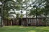 Administration Building |
September 3, 2010 (#10000626) |
831 SE 172 Rd.[6] 34°48′26″N 95°18′29″W |
Wilburton vicinity | |
| 2 | Ash Creek School | 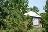 Ash Creek School |
September 8, 1988 (#88001392) |
Off Ash Creek Rd. 35°00′42″N 95°23′15″W |
Wilburton | |
| 3 | Bowers School | September 8, 1988 (#88001393) |
Off U.S. Route 270 on a county road 34°54′49″N 95°25′17″W |
Wilburton | ||
| 4 | Cambria School | 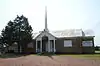 Cambria School |
September 8, 1988 (#88001394) |
Northeast of Hartshorne 34°53′00″N 95°30′18″W |
Hartshorne | |
| 5 | Colony Park Pavilion | 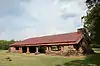 Colony Park Pavilion |
September 8, 1988 (#88001395) |
Veterans Colony 34°48′41″N 95°18′28″W |
Wilburton | |
| 6 | Cupco Church | 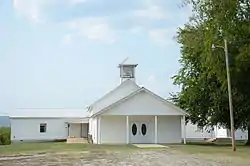 Cupco Church |
November 6, 1980 (#80003273) |
South of Yanush off State Highway 2 34°41′45″N 95°18′33″W |
Yanush | |
| 7 | Degnan School | 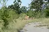 Degnan School |
September 8, 1988 (#88001396) |
Northwest of Wilburton off State Highway 2 34°56′49″N 95°21′08″W |
Wilburton | |
| 8 | Eastern Oklahoma Tuberculosis Sanatorium | 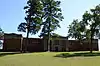 Eastern Oklahoma Tuberculosis Sanatorium |
April 6, 2011 (#10001008) |
10014 SE 1138th Ave. 34°45′18″N 95°04′39″W |
Talihina vicinity | |
| 9 | Edwards Store | April 13, 1972 (#72001069) |
8 miles northeast of Red Oak 34°59′50″N 94°58′17″W |
Red Oak | ||
| 10 | Great Western Coal and Coke Company Building | November 6, 1980 (#80003268) |
701 E. Main St. 34°55′00″N 95°17′37″W |
Wilburton | Demolished. | |
| 11 | Great Western Coal and Coke Company Mine No. 3 | November 6, 1980 (#80003269) |
Off U.S. Route 270 34°54′58″N 95°17′51″W |
Wilburton | ||
| 12 | Holloway's Station | 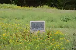 Holloway's Station |
April 13, 1972 (#72001070) |
About 5 miles northeast of Red Oak 34°58′39″N 95°02′54″W |
Red Oak | |
| 13 | Lake Wister Locality | August 19, 1975 (#75001566) |
Address Restricted |
Wister | Extends into Le Flore County | |
| 14 | McLaughlin Site | June 28, 1972 (#72001071) |
Address Restricted |
Red Oak | ||
| 15 | Mitchell Hall | 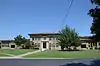 Mitchell Hall |
November 6, 1980 (#80003270) |
Eastern Oklahoma State College campus 34°54′33″N 95°19′18″W |
Wilburton | |
| 16 | Panola High School and Gymnasium | September 8, 1988 (#88001397) |
Off U.S. Route 270, on the southern side of the railroad tracks 34°55′40″N 95°12′52″W |
Panola | Entire building has been either rebuilt or covered entirely with metal siding. | |
| 17 | Pusley's Station | April 13, 1972 (#72001068) |
2 miles southwest of Higgins 34°41′52″N 95°28′15″W |
Higgins | On private property -not accessible. | |
| 18 | Riddle's Station Site | 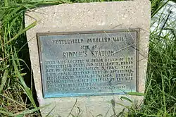 Riddle's Station Site |
June 13, 1972 (#72001072) |
About 3 miles east of Wilburton 34°55′14″N 95°15′24″W |
Wilburton | |
| 19 | Robbers Cave State Park | 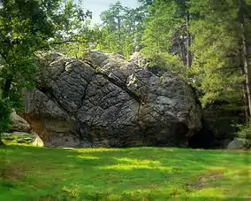 Robbers Cave State Park |
August 23, 2002 (#96000489) |
7.3 miles north of the junction of State Highways 2 and 270 34°58′59″N 95°21′28″W |
Wilburton | |
| 20 | Rosenstein Building | 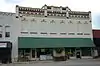 Rosenstein Building |
June 27, 1980 (#80003271) |
111 E. Main St. 34°55′12″N 95°17′57″W |
Wilburton | |
| 21 | Sacred Heart Catholic Church and Rectory | 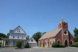 Sacred Heart Catholic Church and Rectory |
November 6, 1980 (#80003272) |
102 Center Point Rd. 34°55′00″N 95°18′44″W |
Wilburton |
See also
| Wikimedia Commons has media related to National Register of Historic Places in Latimer County, Oklahoma. |
References
- The latitude and longitude information provided in this table was derived originally from the National Register Information System, which has been found to be fairly accurate for about 99% of listings. Some locations in this table may have been corrected to current GPS standards.
- "National Register of Historic Places: Weekly List Actions". National Park Service, United States Department of the Interior. Retrieved on January 29, 2021.
- Numbers represent an alphabetical ordering by significant words. Various colorings, defined here, differentiate National Historic Landmarks and historic districts from other NRHP buildings, structures, sites or objects.
- "National Register Information System". National Register of Historic Places. National Park Service. March 13, 2009.
- The eight-digit number below each date is the number assigned to each location in the National Register Information System database, which can be viewed by clicking the number.
- Geocode coordinates estimated from description in NRHP nomination form.
| Topics | |
|---|---|
| Lists by state |
|
| Lists by insular areas | |
| Lists by associated state | |
| Other areas | |
| Related | |
| |
Municipalities and communities of Latimer County, Oklahoma, United States | ||
|---|---|---|
| City | Latimer County map | |
| Towns | ||
| CDPs | ||
| Indian reservation | ||
| Footnotes | ‡This populated place also has portions in another county or counties | |
| ||
This article is issued from Wikipedia. The text is licensed under Creative Commons - Attribution - Sharealike. Additional terms may apply for the media files.