National Register of Historic Places listings in Haskell County, Oklahoma
This is a list of the National Register of Historic Places listings in Haskell County, Oklahoma.

Location of Haskell County in Oklahoma
This is intended to be a complete list of the properties on the National Register of Historic Places in Haskell County, Oklahoma, United States. The locations of National Register properties for which the latitude and longitude coordinates are included below, may be seen in a map.[1]
There are 10 properties listed on the National Register in the county.
- This National Park Service list is complete through NPS recent listings posted January 29, 2021.[2]
Current listings
| [3] | Name on the Register[4] | Image | Date listed[5] | Location | City or town | Description |
|---|---|---|---|---|---|---|
| 1 | Cotton Storage House | January 10, 1980 (#80003263) |
Off State Highway 2 35°07′08″N 95°13′57″W |
Kinta | ||
| 2 | Haskell County Courthouse |  Haskell County Courthouse |
August 23, 1984 (#84003061) |
202 E. Main St. 35°15′14″N 95°04′48″W |
Stigler | |
| 3 | Kinta High School | 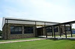 Kinta High School |
September 26, 1988 (#88001383) |
State Highway 2 35°06′30″N 95°14′15″W |
Kinta | |
| 4 | Edmund McCurtain House | June 27, 1980 (#80003265) |
Northeast of Kinta 35°07′43″N 95°09′43″W |
Kinta | ||
| 5 | Green McCurtain House |  Green McCurtain House |
June 21, 1971 (#71000661) |
Northeast of Kinta 35°07′43″N 95°09′25″W |
Kinta | |
| 6 | Mule Creek Site | September 13, 1978 (#78002237) |
Address Restricted |
Stigler | ||
| 7 | Otter Creek Archeological Site | December 31, 1974 (#74001661) |
Address Restricted |
Keota | ||
| 8 | Scott Store | January 11, 1980 (#80003264) |
State Highway 2 35°07′04″N 95°13′53″W |
Kinta | ||
| 9 | Stigler School Gymnasium-Auditorium | 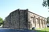 Stigler School Gymnasium-Auditorium |
September 8, 1988 (#88001384) |
4th and E Sts. 35°15′31″N 95°07′40″W |
Stigler | |
| 10 | Tamaha Jail and Ferry Landing | 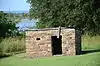 Tamaha Jail and Ferry Landing |
November 14, 1980 (#80003266) |
Northeast of Stigler 35°24′03″N 94°58′42″W |
Stigler |
See also
| Wikimedia Commons has media related to National Register of Historic Places in Haskell County, Oklahoma. |
References
- The latitude and longitude information provided in this table was derived originally from the National Register Information System, which has been found to be fairly accurate for about 99% of listings. Some locations in this table may have been corrected to current GPS standards.
- "National Register of Historic Places: Weekly List Actions". National Park Service, United States Department of the Interior. Retrieved on January 29, 2021.
- Numbers represent an alphabetical ordering by significant words. Various colorings, defined here, differentiate National Historic Landmarks and historic districts from other NRHP buildings, structures, sites or objects.
- "National Register Information System". National Register of Historic Places. National Park Service. March 13, 2009.
- The eight-digit number below each date is the number assigned to each location in the National Register Information System database, which can be viewed by clicking the number.
| Topics | |
|---|---|
| Lists by state |
|
| Lists by insular areas | |
| Lists by associated state | |
| Other areas | |
| Related | |
| |
Municipalities and communities of Haskell County, Oklahoma, United States | ||
|---|---|---|
| City | Haskell County map | |
| Towns | ||
| CDP | ||
| Other unincorporated community | ||
| Indian reservation | ||
| Footnotes | ‡This populated place also has portions in another county or counties | |
| ||
This article is issued from Wikipedia. The text is licensed under Creative Commons - Attribution - Sharealike. Additional terms may apply for the media files.