National Register of Historic Places listings in Stephens County, Oklahoma
This is a list of the National Register of Historic Places listings in Stephens County, Oklahoma.
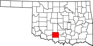
Location of Stephens County in Oklahoma
This is intended to be a complete list of the properties on the National Register of Historic Places in Stephens County, Oklahoma, United States. The locations of National Register properties for which the latitude and longitude coordinates are included below, may be seen in a map.[1]
There are 10 properties listed on the National Register in the county.
- This National Park Service list is complete through NPS recent listings posted January 29, 2021.[2]
Current listings
| [3] | Name on the Register[4] | Image | Date listed[5] | Location | City or town | Description |
|---|---|---|---|---|---|---|
| 1 | Brittain-Garvin House |  Brittain-Garvin House |
August 31, 2000 (#00001039) |
411 North 9th St. 34°30′26″N 97°57′27″W |
Duncan | |
| 2 | H.C. Chrislip House | 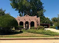 H.C. Chrislip House |
August 6, 1993 (#93000677) |
709 N. 14th St. 34°30′40″N 97°57′53″W |
Duncan | |
| 3 | Duncan Armory |  Duncan Armory |
December 13, 1996 (#96001490) |
100 feet from the junction of 14th St. and an unmarked alley between Fuqua Park and Ash Ave. 34°30′22″N 97°57′55″W |
Duncan | |
| 4 | Duncan Public Library | 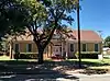 Duncan Public Library |
November 30, 1999 (#99001427) |
301 N. 8th St. 34°30′19″N 97°57′23″W |
Duncan | |
| 5 | W.T. Foreman House |  W.T. Foreman House |
June 5, 2003 (#03000512) |
814 W. Oak Ave. 34°30′14″N 97°57′27″W |
Duncan | |
| 6 | Johnson Hotel and Boarding House |  Johnson Hotel and Boarding House |
May 14, 1986 (#86001098) |
314 W. Mulberry 34°29′42″N 97°57′04″W |
Duncan | |
| 7 | Marlow Armory |  Marlow Armory |
April 7, 1994 (#94000282) |
702 W. Main St. 34°38′50″N 97°57′49″W |
Marlow | |
| 8 | Montgomery-Linam House | 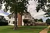 Montgomery-Linam House |
September 22, 1983 (#83002128) |
301 N. 5th St. 34°39′02″N 97°57′29″W |
Marlow | |
| 9 | Patterson Hospital | 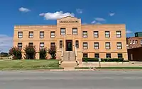 Patterson Hospital |
December 7, 1995 (#95001417) |
929 W. Willow Ave. 34°30′04″N 97°57′33″W |
Duncan | |
| 10 | Louis B. Simmons House | 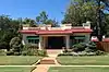 Louis B. Simmons House |
March 2, 2001 (#01000207) |
401 N. 9th St. 34°30′23″N 97°57′27″W |
Duncan |
See also
| Wikimedia Commons has media related to National Register of Historic Places in Stephens County, Oklahoma. |
References
- The latitude and longitude information provided in this table was derived originally from the National Register Information System, which has been found to be fairly accurate for about 99% of listings. Some locations in this table may have been corrected to current GPS standards.
- "National Register of Historic Places: Weekly List Actions". National Park Service, United States Department of the Interior. Retrieved on January 29, 2021.
- Numbers represent an alphabetical ordering by significant words. Various colorings, defined here, differentiate National Historic Landmarks and historic districts from other NRHP buildings, structures, sites or objects.
- "National Register Information System". National Register of Historic Places. National Park Service. March 13, 2009.
- The eight-digit number below each date is the number assigned to each location in the National Register Information System database, which can be viewed by clicking the number.
| Topics | |
|---|---|
| Lists by state |
|
| Lists by insular areas | |
| Lists by associated state | |
| Other areas | |
| Related | |
| |
Municipalities and communities of Stephens County, Oklahoma, United States | ||
|---|---|---|
| Cities | Stephens County map | |
| Towns | ||
| CDP | ||
| Unincorporated communities | ||
| Ghost town | ||
| Indian reservation | ||
| Footnotes | ‡This populated place also has portions in an adjacent county or counties | |
| ||
This article is issued from Wikipedia. The text is licensed under Creative Commons - Attribution - Sharealike. Additional terms may apply for the media files.