National Register of Historic Places listings in McIntosh County, Oklahoma
This is a list of the National Register of Historic Places listings in McIntosh County, Oklahoma.
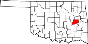
Location of McIntosh County in Oklahoma
This is intended to be a complete list of the properties and districts on the National Register of Historic Places in McIntosh County, Oklahoma, United States. The locations of National Register properties and districts for which the latitude and longitude coordinates are included below, may be seen in a map.[1]
There are 15 properties and districts listed on the National Register in the county.
- This National Park Service list is complete through NPS recent listings posted January 29, 2021.[2]
Current listings
| [3] | Name on the Register[4] | Image | Date listed[5] | Location | City or town | Description |
|---|---|---|---|---|---|---|
| 1 | Checotah Business District | 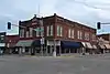 Checotah Business District |
September 13, 1982 (#82003688) |
Gentry Ave. between W. 1st and W. Main Sts. and Broadway Ave. between Lafayette and Spaulding Aves. 35°28′12″N 95°31′22″W |
Checotah | |
| 2 | Checotah City Hall | 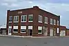 Checotah City Hall |
June 26, 1998 (#98000733) |
201 N. Broadway 35°28′15″N 95°31′20″W |
Checotah | |
| 3 | Checotah MKT Depot |  Checotah MKT Depot |
September 5, 1991 (#91001371) |
Paul Carr Dr. 35°28′16″N 95°32′12″W |
Checotah | |
| 4 | C.L. Cooper Building |  C.L. Cooper Building |
March 22, 1985 (#85000684) |
S. B St. and Harrison 35°17′03″N 95°34′47″W |
Eufaula | |
| 5 | Eufaula Armory | 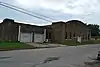 Eufaula Armory |
May 20, 1994 (#94000481) |
48 Memorial Dr. 35°17′21″N 95°34′54″W |
Eufaula | |
| 6 | Eufaula Business District | 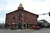 Eufaula Business District |
April 14, 1988 (#88000400) |
Main St. between Pine and Grand Sts. 35°17′12″N 95°34′56″W |
Eufaula | |
| 7 | First Soil Conservation District Dedication Site | September 20, 1982 (#82003689) |
North of Eufaula 35°18′28″N 95°37′00″W |
Eufaula | ||
| 8 | Honey Springs Battlefield |  Honey Springs Battlefield |
September 29, 1970 (#70000848) |
North of Rentiesville 35°32′41″N 95°28′41″W |
Rentiesville | Extends into Muskogee County |
| 9 | Johnson Lake Shelters | December 15, 1978 (#78003086) |
Address Restricted |
Warner | ||
| 10 | McIntosh County Courthouse | 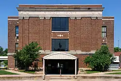 McIntosh County Courthouse |
March 22, 1985 (#85000683) |
110 N. 1st St. 35°17′13″N 95°35′03″W |
Eufaula | |
| 11 | Methodist Episcopal Church, South | 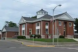 Methodist Episcopal Church, South |
November 13, 1984 (#84000462) |
419 W. Gentry St. 35°28′14″N 95°31′28″W |
Checotah | |
| 12 | Oklahoma Odd Fellows Home at Checotah | 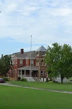 Oklahoma Odd Fellows Home at Checotah |
June 14, 2001 (#01000660) |
211 W. North St. 35°28′46″N 95°31′15″W |
Checotah | |
| 13 | Rock Front | 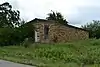 Rock Front |
June 22, 1984 (#84003152) |
Broadway 35°12′50″N 95°55′34″W |
Vernon | |
| 14 | Slippery Moss Shelter | December 15, 1978 (#78003085) |
Address Restricted |
Texanna | ||
| 15 | Tabor House |  Tabor House |
September 23, 1996 (#96000979) |
631 W. Lafayette 35°28′13″N 95°31′40″W |
Checotah |
See also
| Wikimedia Commons has media related to National Register of Historic Places in McIntosh County, Oklahoma. |
References
- The latitude and longitude information provided in this table was derived originally from the National Register Information System, which has been found to be fairly accurate for about 99% of listings. Some locations in this table may have been corrected to current GPS standards.
- "National Register of Historic Places: Weekly List Actions". National Park Service, United States Department of the Interior. Retrieved on January 29, 2021.
- Numbers represent an alphabetical ordering by significant words. Various colorings, defined here, differentiate National Historic Landmarks and historic districts from other NRHP buildings, structures, sites or objects.
- "National Register Information System". National Register of Historic Places. National Park Service. March 13, 2009.
- The eight-digit number below each date is the number assigned to each location in the National Register Information System database, which can be viewed by clicking the number.
| Topics | |
|---|---|
| Lists by state |
|
| Lists by insular areas | |
| Lists by associated state | |
| Other areas | |
| Related | |
| |
Municipalities and communities of McIntosh County, Oklahoma, United States | ||
|---|---|---|
| Cities | McIntosh County map | |
| Towns | ||
| CDPs | ||
| Unincorporated communities | ||
| Indian reservations | ||
| Footnotes | ‡This populated place also has portions in an adjacent county or counties | |
| ||
This article is issued from Wikipedia. The text is licensed under Creative Commons - Attribution - Sharealike. Additional terms may apply for the media files.