National Register of Historic Places listings in Noble County, Oklahoma
This is a list of the National Register of Historic Places listings in Noble County, Oklahoma.
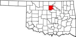
Location of Noble County in Oklahoma
This is intended to be a complete list of the properties and districts on the National Register of Historic Places in Noble County, Oklahoma, United States. The locations of National Register properties and districts for which the latitude and longitude coordinates are included below, may be seen in a map.[1]
There are 13 properties and districts listed on the National Register in the county.
- This National Park Service list is complete through NPS recent listings posted January 29, 2021.[2]
Current listings
| [3] | Name on the Register[4] | Image | Date listed[5] | Location | City or town | Description |
|---|---|---|---|---|---|---|
| 1 | First National Bank and Trust Company Building |  First National Bank and Trust Company Building |
May 16, 1979 (#79002003) |
300 N. 6th St. 36°17′10″N 97°17′07″W |
Perry | |
| 2 | Morrison Baptist Church |  Morrison Baptist Church |
September 28, 1984 (#84003357) |
202 3rd St. 36°17′55″N 97°00′27″W |
Morrison | |
| 3 | Morrison Suspension Bridge | May 23, 1980 (#80003277) |
East of Morrison off U.S. Route 64 36°18′30″N 96°57′05″W |
Morrison | Destroyed | |
| 4 | Noble County Courthouse | 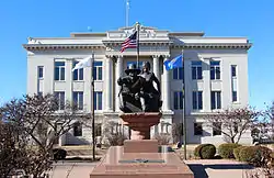 Noble County Courthouse |
August 23, 1984 (#84003361) |
Courthouse Square 36°17′12″N 97°17′11″W |
Perry | |
| 5 | Perry Armory | 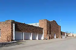 Perry Armory |
September 8, 1988 (#88001362) |
Delaware and 14th Sts. 36°17′13″N 97°17′57″W |
Perry | |
| 6 | Perry Courthouse Square Historic District | Perry Courthouse Square Historic District |
September 2, 2003 (#03000881) |
Roughly bounded by Birch, Elm, 6th and 7th 36°17′13″N 97°17′13″W |
Perry | |
| 7 | Perry Lake Park | 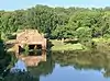 Perry Lake Park |
June 1, 2007 (#07000523) |
1520 S. 4th St. 36°16′01″N 97°16′41″W |
Perry | |
| 8 | Rein School | 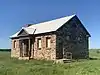 Rein School |
September 8, 1988 (#88001361) |
Off U.S. Route 177 36°33′55″N 97°04′07″W |
Ponca City vicinity | |
| 9 | Renfrow Building | 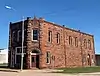 Renfrow Building |
September 28, 1984 (#84003365) |
127 W. Main St. 36°31′42″N 97°26′41″W |
Billings | |
| 10 | Renfrow House |  Renfrow House |
September 28, 1984 (#84003373) |
Graves St. and Broadway 36°31′39″N 97°26′43″W |
Billings | |
| 11 | Schultz-Neal Stone Barn | December 7, 2020 (#100005861) |
250 yds. east of US 177/OK 15, 7 miles (11 km) southeast of Red Rock 36°25′35″N 97°04′04″W |
Red Rock vicinity | ||
| 12 | Sumner School | 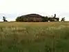 Sumner School |
April 26, 1996 (#96000492) |
County Road N3300, 2 miles north of U.S. Route 64 36°19′06″N 97°07′21″W |
Morrison | |
| 13 | Wolleson-Nicewander Building |  Wolleson-Nicewander Building |
May 16, 1979 (#79002004) |
615 Delaware St. 36°17′15″N 97°17′12″W |
Perry |
See also
| Wikimedia Commons has media related to National Register of Historic Places in Noble County, Oklahoma. |
References
- The latitude and longitude information provided in this table was derived originally from the National Register Information System, which has been found to be fairly accurate for about 99% of listings. Some locations in this table may have been corrected to current GPS standards.
- "National Register of Historic Places: Weekly List Actions". National Park Service, United States Department of the Interior. Retrieved on January 29, 2021.
- Numbers represent an alphabetical ordering by significant words. Various colorings, defined here, differentiate National Historic Landmarks and historic districts from other NRHP buildings, structures, sites or objects.
- "National Register Information System". National Register of Historic Places. National Park Service. March 13, 2009.
- The eight-digit number below each date is the number assigned to each location in the National Register Information System database, which can be viewed by clicking the number.
| Topics | |
|---|---|
| Lists by state |
|
| Lists by insular areas | |
| Lists by associated state | |
| Other areas | |
| Related | |
| |
Municipalities and communities of Noble County, Oklahoma, United States | ||
|---|---|---|
| City | Noble County map | |
| Towns | ||
| CDP | ||
| Unincorporated communities | ||
| ||
This article is issued from Wikipedia. The text is licensed under Creative Commons - Attribution - Sharealike. Additional terms may apply for the media files.