National Register of Historic Places listings in Custer County, Oklahoma
This is a list of the National Register of Historic Places listings in Custer County, Oklahoma.
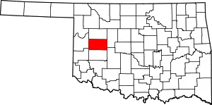
Location of Custer County in Oklahoma
This is intended to be a complete list of the properties and districts on the National Register of Historic Places in Custer County, Oklahoma, United States. The locations of National Register properties and districts for which the latitude and longitude coordinates are included below, may be seen in a map.[1]
There are 14 properties and districts listed on the National Register in the county.
- This National Park Service list is complete through NPS recent listings posted January 29, 2021.[2]
Current listings
| [3] | Name on the Register[4] | Image | Date listed[5] | Location | City or town | Description |
|---|---|---|---|---|---|---|
| 1 | Broadway Hotel | March 6, 1985 (#85000489) |
Off State Highway 33 35°39′56″N 98°53′00″W |
Custer City | ||
| 2 | Clinton Armory |  Clinton Armory |
April 7, 1994 (#94000281) |
723 S. 13th St. 35°30′25″N 98°58′31″W |
Clinton | |
| 3 | Crawford House | _(23055930951).jpg.webp) Crawford House |
March 8, 1984 (#84002998) |
600 N. 13th St. 35°31′10″N 98°58′34″W |
Clinton | |
| 4 | First National Bank of Custer City | October 31, 1985 (#85003426) |
Off State Highway 33 35°39′55″N 98°53′00″W |
Custer City | ||
| 5 | Heerwald Site | March 12, 2012 (#12000112) |
Address Restricted |
Clinton vicinity | ||
| 6 | Hodge Site | December 15, 1978 (#78002232) |
Address Restricted |
Hammon | ||
| 7 | Little Deer Site | November 27, 1978 (#78002233) |
Address Restricted |
Weatherford | ||
| 8 | McLain Rogers Park | 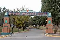 McLain Rogers Park |
September 3, 2004 (#04000944) |
Junction of 10th and Bess Rogers Dr. 35°30′20″N 98°58′25″W |
Clinton | |
| 9 | Owl Blacksmith Shop | July 27, 1983 (#83002084) |
208 W. Rainey 35°31′29″N 98°42′35″W |
Weatherford | ||
| 10 | J.J. Pyeatt's General Store | March 6, 1985 (#85000488) |
Off State Highway 33 35°39′56″N 98°52′58″W |
Custer City | ||
| 11 | Science Building | 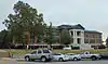 Science Building |
February 23, 1984 (#84003004) |
State St. 35°32′07″N 98°42′22″W |
Weatherford | |
| 12 | Thomas Community Building | June 8, 2011 (#11000335) |
120 E. Broadway 35°44′38″N 98°44′51″W |
Thomas | ||
| 13 | Weatherford Armory | 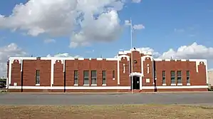 Weatherford Armory |
May 20, 1994 (#94000492) |
123 W. Rainey St. 35°31′30″N 98°42′35″W |
Weatherford | |
| 14 | Y Service Station and Cafe | May 27, 2004 (#04000523) |
1733 Neptune Dr. 35°28′57″N 98°58′47″W |
Clinton |
See also
| Wikimedia Commons has media related to National Register of Historic Places in Custer County, Oklahoma. |
References
- The latitude and longitude information provided in this table was derived originally from the National Register Information System, which has been found to be fairly accurate for about 99% of listings. Some locations in this table may have been corrected to current GPS standards.
- "National Register of Historic Places: Weekly List Actions". National Park Service, United States Department of the Interior. Retrieved on January 29, 2021.
- Numbers represent an alphabetical ordering by significant words. Various colorings, defined here, differentiate National Historic Landmarks and historic districts from other NRHP buildings, structures, sites or objects.
- "National Register Information System". National Register of Historic Places. National Park Service. March 13, 2009.
- The eight-digit number below each date is the number assigned to each location in the National Register Information System database, which can be viewed by clicking the number.
| Topics | |
|---|---|
| Lists by state |
|
| Lists by insular areas | |
| Lists by associated state | |
| Other areas | |
| Related | |
| |
Municipalities and communities of Custer County, Oklahoma, United States | ||
|---|---|---|
| Cities | Custer County map | |
| Towns | ||
| Unincorporated communities | ||
| Ghost town | ||
| Footnotes | ‡This populated place also has portions in an adjacent county or counties | |
| ||
This article is issued from Wikipedia. The text is licensed under Creative Commons - Attribution - Sharealike. Additional terms may apply for the media files.