National Register of Historic Places listings in Pottawatomie County, Oklahoma
This is a list of the National Register of Historic Places listings in Pottawatomie County, Oklahoma.
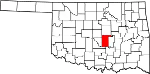
Location of Pottawatomie County in Oklahoma
This is intended to be a complete list of the properties and districts on the National Register of Historic Places in Pottawatomie County, Oklahoma, United States. The locations of National Register properties and districts for which the latitude and longitude coordinates are included below, may be seen in a map.[1]
There are 19 properties and districts listed on the National Register in the county.
- This National Park Service list is complete through NPS recent listings posted January 29, 2021.[2]
Current listings
| [3] | Name on the Register[4] | Image | Date listed[5] | Location | City or town | Description |
|---|---|---|---|---|---|---|
| 1 | Aldridge Hotel | 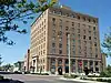 Aldridge Hotel |
June 2, 2000 (#00000622) |
20–24 E. 9th St. 35°19′44″N 96°55′19″W |
Shawnee | |
| 2 | Barnard Elementary School | 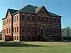 Barnard Elementary School |
June 2, 2000 (#00000624) |
315 E. Locust St. 35°15′15″N 96°56′01″W |
Tecumseh | |
| 3 | Beard Cabin | 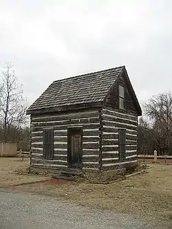 Beard Cabin |
April 8, 1983 (#83002121) |
614 E. Main St. 35°19′43″N 96°54′59″W |
Shawnee | |
| 4 | Bell Street Historic District | 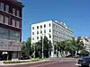 Bell Street Historic District |
December 28, 2000 (#00001579) |
Along N. Bell St. from E. 9th St. to E. Main St. 35°19′40″N 96°55′18″W |
Shawnee | |
| 5 | Billington Building | 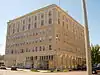 Billington Building |
September 26, 1985 (#85002512) |
23 E. 9th 35°19′43″N 96°56′00″W |
Shawnee | |
| 6 | H. T. Douglas Mansion and Garage | 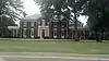 H. T. Douglas Mansion and Garage |
September 26, 1985 (#85002517) |
100 E. Federal St. 35°21′16″N 96°55′17″W |
Shawnee | |
| 7 | Governors Mansion | 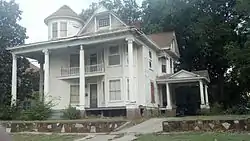 Governors Mansion |
January 21, 1983 (#83002122) |
618 N. Park St. 35°20′09″N 96°55′36″W |
Shawnee | |
| 8 | Kerfoot House | 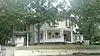 Kerfoot House |
January 21, 1983 (#83002123) |
740 N. Beard St. 35°20′19″N 96°55′27″W |
Shawnee | |
| 9 | Nuckolls House | 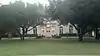 Nuckolls House |
January 21, 1983 (#83002124) |
200 E. Federal St. 35°21′17″N 96°55′13″W |
Shawnee | |
| 10 | Old Santa Fe Railroad Bridge | 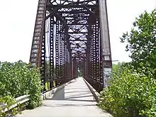 Old Santa Fe Railroad Bridge |
March 10, 2010 (#10000070) |
Drummond Rd. 34°55′09″N 97°03′01″W |
Wanette | Also known as the Wanette-Byers Bridge[6] |
| 11 | Pottawatomie County Courthouse | 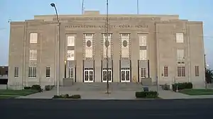 Pottawatomie County Courthouse |
August 24, 1984 (#84003424) |
300 N. Broadway Ave. 35°19′51″N 96°55′21″W |
Shawnee | |
| 12 | Rose-Fast Site (34PT28) |  Rose-Fast Site (34PT28) |
December 24, 1986 (#86003479) |
Address Restricted |
Harjo | |
| 13 | Sacred Heart Mission Site | 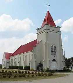 Sacred Heart Mission Site |
September 15, 1983 (#83002125) |
Off State Highway 39 35°00′04″N 96°48′33″W |
Asher | |
| 14 | St. Gregory's Abbey and College | 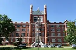 St. Gregory's Abbey and College |
August 15, 1975 (#75001572) |
1900 W. MacArthur Dr. 35°22′03″N 96°57′14″W |
Shawnee | |
| 15 | Santa Fe Depot |  Santa Fe Depot |
June 5, 1974 (#74001667) |
614 E. Main St. 35°19′41″N 96°54′57″W |
Shawnee | |
| 16 | Shawnee Friends Mission | 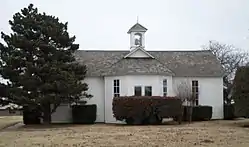 Shawnee Friends Mission |
March 7, 1973 (#73001569) |
2 miles south of Shawnee 35°17′37″N 96°55′28″W |
Shawnee | |
| 17 | Squirrel Creek Bridge | 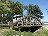 Squirrel Creek Bridge |
September 3, 2010 (#10000625) |
Carries Rangeline Rd. over Squirrel Creek 35°18′01″N 96°55′48″W |
Shawnee vicinity | |
| 18 | State National Bank Building | 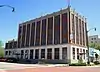 State National Bank Building |
March 13, 2020 (#100005083) |
2 E. Main St. 35°19′39″N 96°55′24″W |
Shawnee | |
| 19 | Walker House | 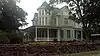 Walker House |
April 8, 1983 (#83002126) |
1801 N. Broadway Ave. 35°21′03″N 96°55′22″W |
Shawnee |
See also
| Wikimedia Commons has media related to National Register of Historic Places in Pottawatomie County, Oklahoma. |
References
- The latitude and longitude information provided in this table was derived originally from the National Register Information System, which has been found to be fairly accurate for about 99% of listings. Some locations in this table may have been corrected to current GPS standards.
- "National Register of Historic Places: Weekly List Actions". National Park Service, United States Department of the Interior. Retrieved on January 29, 2021.
- Numbers represent an alphabetical ordering by significant words. Various colorings, defined here, differentiate National Historic Landmarks and historic districts from other NRHP buildings, structures, sites or objects.
- "National Register Information System". National Register of Historic Places. National Park Service. March 13, 2009.
- The eight-digit number below each date is the number assigned to each location in the National Register Information System database, which can be viewed by clicking the number.
- "Wanette-Byers Bridge". March 21, 2010. Retrieved March 22, 2010.
| Asher | ||
|---|---|---|
| Harjo |
| |
| Shawnee |
| |
| Tecumseh |
| |
| Wanette | ||
| Topics | |
|---|---|
| Lists by state |
|
| Lists by insular areas | |
| Lists by associated state | |
| Other areas | |
| Related | |
| |
Municipalities and communities of Pottawatomie County, Oklahoma, United States | ||
|---|---|---|
| Cities | Pottawatomie County map | |
| Towns | ||
| CDP | ||
| Other unincorporated communities |
| |
| Ghost towns | ||
| Footnotes | ‡This populated place also has portions in an adjacent county or counties | |
| ||
This article is issued from Wikipedia. The text is licensed under Creative Commons - Attribution - Sharealike. Additional terms may apply for the media files.