National Register of Historic Places listings in Woods County, Oklahoma
This is intended to be a complete list of the properties on the National Register of Historic Places in Woods County, Oklahoma, United States. The locations of National Register properties for which the latitude and longitude coordinates are included below, may be seen in a map.[1]
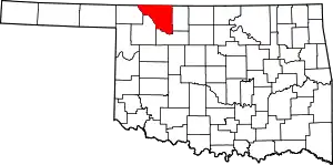
Location of Woods County in Oklahoma
There are 15 properties listed on the National Register in the county.
- This National Park Service list is complete through NPS recent listings posted January 29, 2021.[2]
Current listings
| [3] | Name on the Register[4] | Image | Date listed[5] | Location | City or town | Description |
|---|---|---|---|---|---|---|
| 1 | Alva Armory | September 8, 1988 (#88001360) |
Choctaw and 3rd Sts. 36°48′24″N 98°39′40″W |
Alva | ||
| 2 | Branson Building | January 5, 1984 (#84000700) |
531 Barnes St. 36°48′12″N 98°40′01″W |
Alva | ||
| 3 | Building at 405–407 College Avenue | January 5, 1984 (#84000702) |
405 College Ave. 36°48′15″N 98°40′01″W |
Alva | ||
| 4 | Building at 409 College Avenue | January 5, 1984 (#84000703) |
409 College Ave. 36°48′15″N 98°40′01″W |
Alva | ||
| 5 | Building at 500 Flynn Street | January 5, 1984 (#84000704) |
500 Flynn St. 36°48′18″N 98°39′55″W |
Alva | ||
| 6 | Central National Bank | 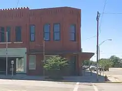 Central National Bank |
January 5, 1984 (#84000705) |
401 College Ave. 36°48′17″N 98°40′02″W |
Alva | |
| 7 | First Congregational Church | December 4, 2017 (#100001871) |
1887 E. Cecil St. 36°35′08″N 98°52′41″W |
Waynoka | ||
| 8 | Hotel Bell | June 14, 2013 (#13000395) |
505 Barnes 36°48′13″N 98°39′56″W |
Alva | ||
| 9 | I.O.O.F. Hall | January 5, 1984 (#84000706) |
527 Barnes St. 36°48′12″N 98°39′59″W |
Alva | ||
| 10 | Kavanaugh and Shea Building | January 5, 1984 (#84000707) |
403 College Ave. 36°48′15″N 98°40′01″W |
Alva | ||
| 11 | Nickel Ensor McClure House | September 3, 2010 (#10000623) |
1301 Locust St. 36°48′00″N 98°40′41″W |
Alva | ||
| 12 | Science Hall | July 14, 1983 (#83002141) |
Northwestern Oklahoma State University campus 36°47′48″N 98°40′06″W |
Alva | ||
| 13 | Stine Building | April 21, 1982 (#82003717) |
601 Barnes St. 36°48′12″N 98°40′00″W |
Alva | ||
| 14 | Waynoka Santa Fe Depot and Harvey House | June 20, 1974 (#74001671) |
Along the former Santa Fe railroad tracks 36°35′00″N 98°52′59″W |
Waynoka | ||
| 15 | Waynoka Telephone Exchange Building | September 10, 2014 (#14000597) |
200 S. Main St. 36°35′01″N 98°52′49″W |
Waynoka |
See also
| Wikimedia Commons has media related to National Register of Historic Places in Woods County, Oklahoma. |
References
- The latitude and longitude information provided in this table was derived originally from the National Register Information System, which has been found to be fairly accurate for about 99% of listings. Some locations in this table may have been corrected to current GPS standards.
- "National Register of Historic Places: Weekly List Actions". National Park Service, United States Department of the Interior. Retrieved on January 29, 2021.
- Numbers represent an alphabetical ordering by significant words. Various colorings, defined here, differentiate National Historic Landmarks and historic districts from other NRHP buildings, structures, sites or objects.
- "National Register Information System". National Register of Historic Places. National Park Service. March 13, 2009.
- The eight-digit number below each date is the number assigned to each location in the National Register Information System database, which can be viewed by clicking the number.
| Alva |
| |
|---|---|---|
| Waynoka |
| |
| Topics | |
|---|---|
| Lists by state |
|
| Lists by insular areas | |
| Lists by associated state | |
| Other areas | |
| Related | |
| |
Municipalities and communities of Woods County, Oklahoma, United States | ||
|---|---|---|
| Cities | Woods County map | |
| Towns | ||
| Unincorporated communities | ||
| ||
This article is issued from Wikipedia. The text is licensed under Creative Commons - Attribution - Sharealike. Additional terms may apply for the media files.