National Register of Historic Places listings in Okmulgee County, Oklahoma
This is a list of the National Register of Historic Places listings in Okmulgee County, Oklahoma.
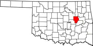
Location of Okmulgee County in Oklahoma
This is intended to be a complete list of the properties and districts on the National Register of Historic Places in Okmulgee County, Oklahoma, United States. The locations of National Register properties and districts for which the latitude and longitude coordinates are included below, may be seen in a map.[1]
There are 20 properties and districts listed on the National Register in the county, including 1 National Historic Landmark.
- This National Park Service list is complete through NPS recent listings posted January 29, 2021.[2]
Current listings
| [3] | Name on the Register[4] | Image | Date listed[5] | Location | City or town | Description |
|---|---|---|---|---|---|---|
| 1 | Creek National Capitol | _Nation_Council_House.jpg.webp) Creek National Capitol |
October 15, 1966 (#66000632) |
6th St. and Grand Ave. 35°37′21″N 95°58′18″W |
Okmulgee | |
| 2 | Eastside Baptist Church | 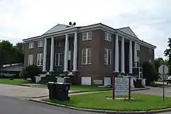 Eastside Baptist Church |
November 23, 1984 (#84000306) |
219 N. Osage Ave. 35°37′33″N 95°57′30″W |
Okmulgee | |
| 3 | First Baptist Central Church | 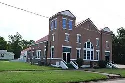 First Baptist Central Church |
November 23, 1984 (#84000307) |
521 N. Central Ave. 35°37′39″N 95°58′11″W |
Okmulgee | |
| 4 | Harmon Athletic Field |  Harmon Athletic Field |
January 25, 1999 (#98001588) |
North of the junction of 12th St. and Creek Ave. 35°37′05″N 95°57′51″W |
Okmulgee | |
| 5 | Hugh Henry House | 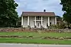 Hugh Henry House |
August 18, 1983 (#83002110) |
N. 3rd St. 35°27′02″N 95°59′00″W |
Henryetta | |
| 6 | Isparhecher House and Grave | July 12, 1976 (#76001573) |
About 4 miles west of Beggs off State Highway 16 35°44′15″N 96°07′50″W |
Beggs | ||
| 7 | Kennedy Mansion | 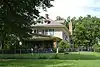 Kennedy Mansion |
December 10, 2014 (#14001032) |
502 S. Okmulgee Ave. 35°37′07″N 95°58′31″W |
Okmulgee | |
| 8 | Lake Okmulgee Dam Spillway Cascade | 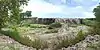 Lake Okmulgee Dam Spillway Cascade |
January 25, 1999 (#98001591) |
State Highway 56, 10 miles west of U.S. Route 62 35°37′19″N 96°03′32″W |
Okmulgee | |
| 9 | Nichols Park | 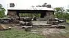 Nichols Park |
December 6, 2006 (#06001115) |
1.9 miles south of the junction of Lake Rd. and Main St. 35°24′23″N 95°58′35″W |
Henryetta | |
| 10 | Nuyaka Mission | April 13, 1972 (#72001075) |
9 miles west of Okmulgee 35°38′59″N 96°09′46″W |
Okmulgee | ||
| 11 | Okmulgee Armory | 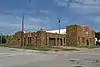 Okmulgee Armory |
January 25, 1999 (#98001589) |
Junction of 2nd and Alabama Sts. 35°37′37″N 95°58′35″W |
Okmulgee | |
| 12 | Okmulgee Colored Hospital | 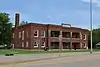 Okmulgee Colored Hospital |
June 22, 1984 (#84003387) |
320 N. Wood Dr. 35°38′03″N 95°57′39″W |
Okmulgee | |
| 13 | Okmulgee Country Club and Golf Course | March 15, 2018 (#100002219) |
1400 S. Mission Ln. 35°36′38″N 95°56′39″W |
Okmulgee | ||
| 14 | Okmulgee County Courthouse | 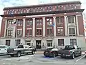 Okmulgee County Courthouse |
August 23, 1984 (#84003390) |
300 W. 7th St. 35°37′20″N 95°58′27″W |
Okmulgee | |
| 15 | Okmulgee Downtown Historic District | 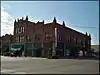 Okmulgee Downtown Historic District |
December 17, 1992 (#92001693) |
Roughly bounded by 4th St., Frisco Ave., 8th St., and Okmulgee Ave. 35°37′22″N 95°58′12″W |
Okmulgee | |
| 16 | Okmulgee Public Library | 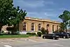 Okmulgee Public Library |
July 28, 1983 (#83002111) |
218 S. Okmulgee Ave. 35°37′17″N 95°58′31″W |
Okmulgee | |
| 17 | Okmulgee Stock Pavilion | 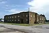 Okmulgee Stock Pavilion |
January 25, 1999 (#98001590) |
Junction of Lagonda and Okmulgee Sts. 35°38′14″N 95°58′29″W |
Okmulgee | |
| 18 | St. Anthony's Catholic Church | 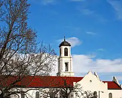 St. Anthony's Catholic Church |
July 14, 1983 (#83002112) |
515 S. Morton St. 35°37′06″N 95°58′20″W |
Okmulgee | |
| 19 | Severs Block | 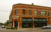 Severs Block |
March 22, 1991 (#91000311) |
101 E. 6th St. 35°37′24″N 95°58′16″W |
Okmulgee | |
| 20 | Wilson School | January 28, 1981 (#81000465) |
Northwest of Henryetta 35°30′28″N 96°02′06″W |
Henryetta | Demolished[6] |
See also
| Wikimedia Commons has media related to National Register of Historic Places in Okmulgee County, Oklahoma. |
References
- The latitude and longitude information provided in this table was derived originally from the National Register Information System, which has been found to be fairly accurate for about 99% of listings. Some locations in this table may have been corrected to current GPS standards.
- "National Register of Historic Places: Weekly List Actions". National Park Service, United States Department of the Interior. Retrieved on January 29, 2021.
- Numbers represent an alphabetical ordering by significant words. Various colorings, defined here, differentiate National Historic Landmarks and historic districts from other NRHP buildings, structures, sites or objects.
- "National Register Information System". National Register of Historic Places. National Park Service. March 13, 2009.
- The eight-digit number below each date is the number assigned to each location in the National Register Information System database, which can be viewed by clicking the number.
- "Wilson School". Oklahoma Historical Society State Historic Preservation Office. Retrieved August 30, 2017.
| Beggs |
| |
|---|---|---|
| Henryetta |
| |
| Okmulgee |
| |
| Topics | |
|---|---|
| Lists by state |
|
| Lists by insular areas | |
| Lists by associated state | |
| Other areas | |
| Related | |
| |
Municipalities and communities of Okmulgee County, Oklahoma, United States | ||
|---|---|---|
| Cities | Okmulgee County map | |
| Towns | ||
| Unincorporated communities | ||
| Indian reservation | ||
| Footnotes | ‡This populated place also has portions in an adjacent county or counties | |
| ||
This article is issued from Wikipedia. The text is licensed under Creative Commons - Attribution - Sharealike. Additional terms may apply for the media files.