National Register of Historic Places listings in Kay County, Oklahoma
This is a list of the National Register of Historic Places listings in Kay County, Oklahoma.
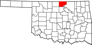
Location of Kay County in Oklahoma
This is intended to be a complete list of the properties and districts on the National Register of Historic Places in Kay County, Oklahoma, United States. The locations of National Register properties and districts for which the latitude and longitude coordinates are included below, may be seen in a map.[1]
There are 58 properties and districts listed on the National Register in the county, including 3 National Historic Landmarks.
- This National Park Service list is complete through NPS recent listings posted January 29, 2021.[2]
Current listings
| [3] | Name on the Register[4] | Image | Date listed[5] | Location | City or town | Description |
|---|---|---|---|---|---|---|
| 1 | One-hundred-and-one Ranch | 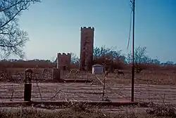 One-hundred-and-one Ranch |
April 11, 1973 (#73001560) |
12 miles southwest of Ponca City on State Highway 156 36°36′47″N 97°08′34″W |
Ponca City | |
| 2 | 101 Rodeo Arena | 101 Rodeo Arena |
December 4, 2017 (#100001865) |
2600 N Ash St. 36°43′11″N 97°05′39″W |
Ponca City | |
| 3 | Alcorn-Pickrel House | December 2, 2020 (#100005564) |
200 North 10th St. 36°42′17″N 97°04′20″W |
Ponca City | ||
| 3 | Attucks Community Center | 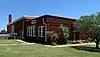 Attucks Community Center |
December 4, 2017 (#100001866) |
1001 S 12th St. 36°41′35″N 97°04′12″W |
Ponca City | |
| 4 | Bennie L. Aupperle Dairy Barn | 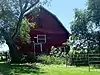 Bennie L. Aupperle Dairy Barn |
December 12, 2012 (#12001038) |
8700 N. La Cann Rd. 36°55′17″N 97°01′49″W |
Newkirk | |
| 5 | Big V Ranch House | 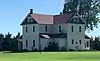 Big V Ranch House |
August 23, 1984 (#84003068) |
Off State Highway 156 36°37′09″N 97°10′31″W |
Ponca City | |
| 6 | Blackwell Armory | Blackwell Armory |
September 8, 1988 (#88001366) |
6th St. and Doolin Avenue 36°48′40″N 97°17′28″W |
Blackwell | |
| 7 | Blaine Stadium and Fieldhouse | Blaine Stadium and Fieldhouse |
September 8, 1988 (#88001364) |
5th and Brookfield Sts. 36°43′06″N 97°04′38″W |
Ponca City | |
| 8 | Bryson Archeological Site | September 20, 1979 (#79001997) |
Address Restricted |
Newkirk | ||
| 9 | Chilocco Indian Agricultural School |  Chilocco Indian Agricultural School |
September 8, 2006 (#06000792) |
U.S. Route 77 and E0018 Rd. 36°59′06″N 97°03′45″W |
Newkirk | |
| 10 | Jack and Helen Cleary House | Jack and Helen Cleary House |
January 30, 2020 (#100004170) |
13 Hillcrest Dr. 36°42′22″N 97°03′44″W |
Ponca City | |
| 11 | Darr School of Aeronautics Hangar No. 3 | Darr School of Aeronautics Hangar No. 3 |
September 8, 2006 (#06000794) |
Southwest of the junction of Darr Park Dr. and Lindsey Rd. 36°44′10″N 97°05′50″W |
Ponca City | |
| 12 | Deer Creek Site | October 15, 1966 (#66000630) |
Address Restricted |
Newkirk | ||
| 13 | Daniel J. Donahoe House | 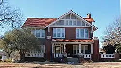 Daniel J. Donahoe House |
March 10, 1982 (#82003686) |
302 S. 7th St. 36°42′04″N 97°04′33″W |
Ponca City | |
| 14 | Downtown Ponca City Historic District | 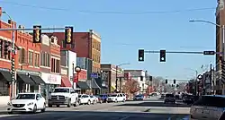 Downtown Ponca City Historic District |
March 21, 2011 (#10001010) |
Roughly bounded by Pine St., Chestnut St., 7th St., and Central Ave. 36°42′15″N 97°04′52″W |
Ponca City | |
| 15 | Electric Park Pavilion | Electric Park Pavilion |
September 29, 1976 (#76001563) |
300 S. Main 36°48′06″N 97°16′54″W |
Blackwell | |
| 16 | First Church of Christ, Scientist | 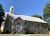 First Church of Christ, Scientist |
March 9, 2015 (#15000063) |
300 N. 3rd St. 36°42′21″N 97°04′52″W |
Ponca City | |
| 17 | First Presbyterian Church |  First Presbyterian Church |
July 15, 2019 (#100004169) |
1505 E. Grand Ave. 36°42′12″N 97°03′57″W |
Ponca City | |
| 18 | First Presbyterian Church of Tonkawa | 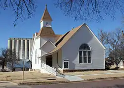 First Presbyterian Church of Tonkawa |
September 22, 1994 (#94001081) |
109 S. 4th St. 36°40′43″N 97°18′18″W |
Tonkawa | |
| 19 | Henry C. Hatashita House | December 13, 2016 (#16000848) |
1408 Pioneer Rd. 36°42′53″N 97°03′58″W |
Ponca City | ||
| 20 | Hayes-Kennedy-Rivoli Theater Building | 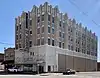 Hayes-Kennedy-Rivoli Theater Building |
June 8, 2015 (#15000327) |
122-124 S. Main 36°48′12″N 97°16′59″W |
Blackwell | |
| 21 | Huston Elementary School | Huston Elementary School |
March 4, 2009 (#09000073) |
304 Vinnedge Ave. 36°47′11″N 97°17′12″W |
Blackwell | |
| 22 | Gov. William W. Jenkins Homestead Site | October 14, 1976 (#76001564) |
Address Restricted |
Newkirk | ||
| 23 | Kaw City Depot | 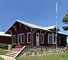 Kaw City Depot |
October 3, 1979 (#79001996) |
West of Kaw City on Washungah Dr. 36°45′53″N 96°51′29″W |
Kaw City | |
| 24 | Kaw Indian Agency | 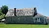 Kaw Indian Agency |
April 11, 1973 (#73001562) |
North of the Arkansas River 36°46′36″N 96°50′00″W |
Washunga | |
| 25 | Kay County Courthouse | 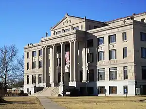 Kay County Courthouse |
August 23, 1984 (#84003070) |
Courthouse Square 36°52′51″N 97°03′14″W |
Newkirk | |
| 26 | Kimbrough Temple C.M.E. Church | September 15, 2020 (#100005555) |
1029 South 12th St. 36°41′33″N 97°04′11″W |
Ponca City | ||
| 27 | Lake Ponca Duck Pond Historic District | Lake Ponca Duck Pond Historic District |
December 8, 2015 (#15000872) |
L.A. Cann Dr. & Edam Rd. 36°43′06″N 97°01′33″W |
Ponca City | |
| 28 | Larkin Hotel | 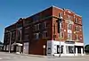 Larkin Hotel |
December 18, 2013 (#13000940) |
201 N. Main St. 36°48′20″N 97°17′00″W |
Blackwell | |
| 29 | Mahoney House and Garage | 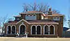 Mahoney House and Garage |
July 3, 1984 (#84003074) |
302 N. Main Ave. 36°40′53″N 97°18′33″W |
Tonkawa | |
| 30 | Marland Estate, Inc. Gatehouse | January 30, 2020 (#100004171) |
747 N. 14th St. 36°42′50″N 97°04′02″W |
Ponca City | ||
| 31 | Charlotte Marland House | July 15, 2019 (#100004168) |
919 E. Grand Ave. 36°42′12″N 97°04′21″W |
Ponca City | ||
| 32 | E. W. Marland Mansion | 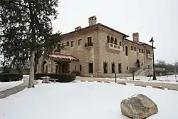 E. W. Marland Mansion |
April 11, 1973 (#73001561) |
Monument Rd. 36°43′00″N 97°03′37″W |
Ponca City | |
| 33 | Marland-Paris House | 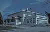 Marland-Paris House |
September 28, 1976 (#76001565) |
1000 E. Grand 36°42′11″N 97°04′17″W |
Ponca City | |
| 34 | James J. McGraw House | 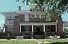 James J. McGraw House |
December 4, 2017 (#100001867) |
400 N. 4th St. 36°42′25″N 97°04′47″W |
Ponca City | |
| 35 | Newkirk Central Business District | 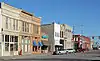 Newkirk Central Business District |
February 23, 1984 (#84003079) |
Main and 7th Sts. 36°54′01″N 97°03′10″W |
Newkirk | |
| 36 | Newkirk Water Purification Plant | 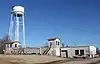 Newkirk Water Purification Plant |
September 8, 1988 (#88001365) |
10th and Elm Sts. 36°52′44″N 97°03′04″W |
Newkirk | |
| 37 | Nez Perce Reservation | February 15, 1974 (#74001663) |
Address Restricted |
Tonkawa | ||
| 38 | Nickles Machine Shop | September 15, 2020 (#100005556) |
600 South 1st St. 36°41′53″N 97°05′03″W |
Ponca City | ||
| 39 | Northside Elementary School | Northside Elementary School |
February 23, 2009 (#09000074) |
720 W. Doolin Ave. 36°48′41″N 97°17′33″W |
Blackwell | |
| 40 | Parkside Elementary School | 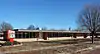 Parkside Elementary School |
February 23, 2009 (#09000075) |
502 E. College Ave. 36°48′05″N 97°16′36″W |
Blackwell | |
| 41 | Pioneer Woman Statue |  Pioneer Woman Statue |
August 31, 1978 (#78002238) |
Monument Circle 36°42′36″N 97°03′55″W |
Ponca City | |
| 42 | Ponca City Milling Company Elevator | 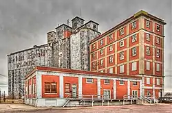 Ponca City Milling Company Elevator |
July 15, 2019 (#100004172) |
114 W. Central Ave. 36°42′10″N 97°05′05″W |
Ponca City | |
| 43 | Ponca City Municipal Airport Hangar | Ponca City Municipal Airport Hangar |
September 30, 2019 (#100004173) |
2231 Waverly St. 36°44′01″N 97°06′12″W |
Ponca City | |
| 44 | Ponca City Power Plant | 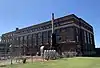 Ponca City Power Plant |
July 15, 2019 (#100004174) |
1420 N. Union St. 36°43′11″N 97°05′07″W |
Ponca City | |
| 45 | Poncan Theatre | 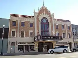 Poncan Theatre |
November 13, 1984 (#84000455) |
104 E. Grand Ave. 36°42′11″N 97°04′58″W |
Ponca City | |
| 46 | Roosevelt Elementary School | 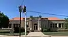 Roosevelt Elementary School |
December 4, 2017 (#100001868) |
815 E. Highland Ave. 36°42′35″N 97°04′25″W |
Ponca City | |
| 47 | St. John Baptist Church and Rectory | 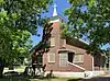 St. John Baptist Church and Rectory |
March 9, 2015 (#15000064) |
1009 S. 11th St. 36°41′35″N 97°04′16″W |
Ponca City | |
| 48 | Santa Fe Depot | Santa Fe Depot |
March 12, 2012 (#12000113) |
Near junction of S. 1st & W. Oklahoma 36°42′06″N 97°05′02″W |
Ponca City | |
| 49 | Sheets House | 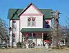 Sheets House |
September 8, 2011 (#11000639) |
1350 Peckham Rd 36°53′01″N 97°04′10″W |
Newkirk | |
| 50 | Soldani Mansion | 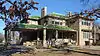 Soldani Mansion |
June 24, 1982 (#82003687) |
819 E. Central Avenue 36°42′09″N 97°04′25″W |
Ponca City | Now the Ponca City Art Center. |
| 51 | Temple Emanuel | 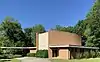 Temple Emanuel |
July 15, 2019 (#100004175) |
1201 E. Highland Ave. 36°42′35″N 97°04′10″W |
Ponca City | |
| 52 | J.P. Tipton Farmstead | J.P. Tipton Farmstead |
February 5, 1998 (#98000073) |
3.1 miles east of Newkirk 36°53′01″N 96°59′08″W |
Newkirk | |
| 53 | Tonkawa Armory | Tonkawa Armory |
September 8, 1988 (#88001363) |
3rd and North Sts. 36°41′25″N 97°18′10″W |
Tonkawa | |
| 54 | Tonkawa Lodge No. 157 A.F. & A.M. | 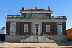 Tonkawa Lodge No. 157 A.F. & A.M. |
September 6, 2007 (#07000910) |
112 N. 7th St. 36°40′45″N 97°18′28″W |
Tonkawa | |
| 55 | Washington Elementary School | 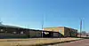 Washington Elementary School |
March 4, 2009 (#09000076) |
723 W. College Ave. 36°48′05″N 97°17′32″W |
Blackwell | |
| 56 | Wentz Camp | September 3, 2010 (#10000620) |
Intersection of L.A. Cann Dr. and E. Prospect Ave. 36°44′18″N 97°01′33″W |
Ponca City | ||
| 57 | White Eagle Park | 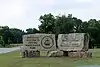 White Eagle Park |
June 8, 2007 (#07000522) |
North of White Eagle 36°36′30″N 97°04′16″W |
White Eagle |
See also
| Wikimedia Commons has media related to National Register of Historic Places in Kay County, Oklahoma. |
References
- The latitude and longitude information provided in this table was derived originally from the National Register Information System, which has been found to be fairly accurate for about 99% of listings. Some locations in this table may have been corrected to current GPS standards.
- "National Register of Historic Places: Weekly List Actions". National Park Service, United States Department of the Interior. Retrieved on January 29, 2021.
- Numbers represent an alphabetical ordering by significant words. Various colorings, defined here, differentiate National Historic Landmarks and historic districts from other NRHP buildings, structures, sites or objects.
- "National Register Information System". National Register of Historic Places. National Park Service. March 13, 2009.
- The eight-digit number below each date is the number assigned to each location in the National Register Information System database, which can be viewed by clicking the number.
| Topics | |
|---|---|
| Lists by state |
|
| Lists by insular areas | |
| Lists by associated state | |
| Other areas | |
| Related | |
| |
Municipalities and communities of Kay County, Oklahoma, United States | ||
|---|---|---|
| Cities | Kay County map | |
| Towns | ||
| CDP | ||
| Unincorporated communities | ||
| Ghost towns | ||
| ||
This article is issued from Wikipedia. The text is licensed under Creative Commons - Attribution - Sharealike. Additional terms may apply for the media files.