National Register of Historic Places listings in Hughes County, Oklahoma
This is a list of the National Register of Historic Places listings in Hughes County, Oklahoma.
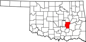
Location of Hughes County in Oklahoma
This is intended to be a complete list of the properties on the National Register of Historic Places in Hughes County, Oklahoma, United States. The locations of National Register properties for which the latitude and longitude coordinates are included below, may be seen in a map.[1]
There are 10 properties listed on the National Register in the county.
- This National Park Service list is complete through NPS recent listings posted January 29, 2021.[2]
Current listings
| [3] | Name on the Register[4] | Image | Date listed[5] | Location | City or town | Description |
|---|---|---|---|---|---|---|
| 1 | Dustin Agricultural Building | September 8, 1988 (#88001385) |
Rutherford and 4th Sts. 35°16′10″N 96°01′45″W |
Dustin | ||
| 2 | Holdenville Armory | 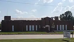 Holdenville Armory |
September 8, 1988 (#88001386) |
U.S. Route 270 and N. Butts St. 35°05′11″N 96°23′01″W |
Holdenville | |
| 3 | Holdenville City Hall | 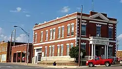 Holdenville City Hall |
September 11, 1981 (#81000463) |
102 Creek St. 35°05′01″N 96°24′07″W |
Holdenville | |
| 4 | Levering Mission | May 16, 1974 (#74001662) |
Northeast of Wetumka 35°14′55″N 96°11′34″W |
Wetumka | ||
| 5 | Moss School Gymnasium | September 8, 1988 (#88001388) |
Off the intersection of U.S. Routes 75 and 270 35°04′18″N 96°13′48″W |
Holdenville | ||
| 6 | Spaulding School Gymnasium-Auditorium | September 8, 1988 (#88001389) |
Section Line Highway and 2nd St. 35°00′42″N 96°26′30″W |
Spaulding | ||
| 7 | Stuart Hotel | October 7, 1982 (#82001496) |
Off U.S. Route 270 34°54′12″N 96°05′55″W |
Stuart | ||
| 8 | John E. Turner House | January 27, 1983 (#83002090) |
401 E. 10th St. 35°04′59″N 96°23′42″W |
Holdenville | ||
| 9 | Wetumka Armory | 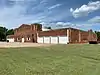 Wetumka Armory |
September 8, 1988 (#88001390) |
St. Louis and Wetumka Sts. 35°14′08″N 96°14′38″W |
Wetumka | |
| 10 | Wetumka Cemetery Pavilion and Fence | 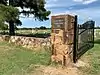 Wetumka Cemetery Pavilion and Fence |
September 8, 1988 (#88001391) |
East of Wetumka 35°14′12″N 96°12′36″W |
Wetumka |
See also
References
- The latitude and longitude information provided in this table was derived originally from the National Register Information System, which has been found to be fairly accurate for about 99% of listings. Some locations in this table may have been corrected to current GPS standards.
- "National Register of Historic Places: Weekly List Actions". National Park Service, United States Department of the Interior. Retrieved on January 29, 2021.
- Numbers represent an alphabetical ordering by significant words. Various colorings, defined here, differentiate National Historic Landmarks and historic districts from other NRHP buildings, structures, sites or objects.
- "National Register Information System". National Register of Historic Places. National Park Service. March 13, 2009.
- The eight-digit number below each date is the number assigned to each location in the National Register Information System database, which can be viewed by clicking the number.
| Topics | |
|---|---|
| Lists by state |
|
| Lists by insular areas | |
| Lists by associated state | |
| Other areas | |
| Related | |
| |
Municipalities and communities of Hughes County, Oklahoma, United States | ||
|---|---|---|
| Cities | Hughes County map | |
| Towns | ||
| Indian reservations | ||
| Footnotes | ‡This populated place also has portions in an adjacent county or counties | |
| ||
This article is issued from Wikipedia. The text is licensed under Creative Commons - Attribution - Sharealike. Additional terms may apply for the media files.