National Register of Historic Places listings in Washita County, Oklahoma
This is a list of the National Register of Historic Places listings in Washita County, Oklahoma.
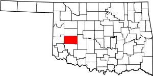
Location of Washita County in Oklahoma
This is intended to be a complete list of the properties and districts on the National Register of Historic Places in Washita County, Oklahoma, United States. The locations of National Register properties and districts for which the latitude and longitude coordinates are included below, may be seen in a map.[1]
There are 6 properties and districts listed on the National Register in the county, including 1 National Historic Landmark.
- This National Park Service list is complete through NPS recent listings posted January 29, 2021.[2]
Current listings
| [3] | Name on the Register[4] | Image | Date listed[5] | Location | City or town | Description |
|---|---|---|---|---|---|---|
| 1 | Canute Service Station | 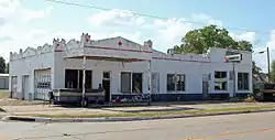 Canute Service Station |
February 9, 1995 (#94001611) |
Southwestern corner of the junction of Main St. and the former U.S. Route 66 35°25′18″N 99°16′49″W |
Canute | |
| 2 | Cedar Creek District | May 29, 1975 (#75001577) |
Address Restricted |
Carnegie | ||
| 3 | Cordell Carnegie Public Library | .jpg.webp) Cordell Carnegie Public Library |
November 13, 1989 (#89001966) |
105 E. 1st St. 35°17′33″N 98°59′22″W |
New Cordell | |
| 4 | McLemore Site | October 15, 1966 (#66000636) |
Address Restricted |
Colony | ||
| 5 | New Cordell Courthouse Square Historic District | 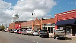 New Cordell Courthouse Square Historic District |
January 7, 1999 (#98001592) |
roughly bounded by Temple, E. 2nd, Glenn English, and E. Clay Sts. 35°17′30″N 98°59′22″W |
New Cordell | |
| 6 | Washita County Courthouse | 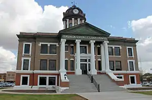 Washita County Courthouse |
August 24, 1984 (#84003452) |
Courthouse Square 35°17′27″N 98°59′22″W |
New Cordell |
Former listing
| [3] | Name on the Register | Image | Date listed | Date removed | Location | City or town | Summary |
|---|---|---|---|---|---|---|---|
| 1 | Seger Indian Training School | August 5, 1971 (#71001080) | 1973 | Eastern edge of Colony 35°20′41″N 98°40′11″W |
Colony | [6] |
See also
| Wikimedia Commons has media related to National Register of Historic Places in Washita County, Oklahoma. |
References
- The latitude and longitude information provided in this table was derived originally from the National Register Information System, which has been found to be fairly accurate for about 99% of listings. Some locations in this table may have been corrected to current GPS standards.
- "National Register of Historic Places: Weekly List Actions". National Park Service, United States Department of the Interior. Retrieved on January 29, 2021.
- Numbers represent an alphabetical ordering by significant words. Various colorings, defined here, differentiate National Historic Landmarks and historic districts from other NRHP buildings, structures, sites or objects.
- "National Register Information System". National Register of Historic Places. National Park Service. March 13, 2009.
- The eight-digit number below each date is the number assigned to each location in the National Register Information System database, which can be viewed by clicking the number.
| Topics | |
|---|---|
| Lists by state |
|
| Lists by insular areas | |
| Lists by associated state | |
| Other areas | |
| Related | |
| |
Municipalities and communities of Washita County, Oklahoma, United States | ||
|---|---|---|
| Cities | Washita County map | |
| Towns | ||
| Unincorporated communities |
| |
| Footnotes | ‡This populated place also has portions in an adjacent county or counties | |
| ||
This article is issued from Wikipedia. The text is licensed under Creative Commons - Attribution - Sharealike. Additional terms may apply for the media files.